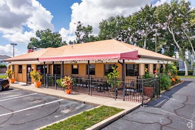
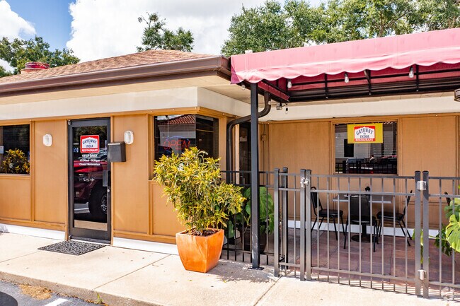
Property Record
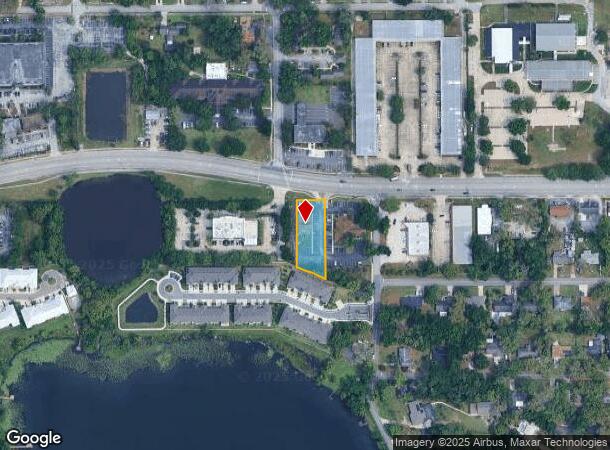
790 E State Road 434, Longwood, FL 32750
NEARBY LISTINGS FOR SALE OR LEASE
Property Detail
790 E State Road 434
Orlando-Kissimmee-Sanford, FL
Wildmere Amended Plat
05-21-30-502-0500-001A
PT OF LOTS 1 & 2 DESC AS BEG NW COR LOT 1 RUN E 126 FT S 284.58 FT N 66 DEG 18 MIN W TO W LI LOT 1 N TO BEG (LESS RD) AMENDED PLAT OF WILDMERE PB 3 PG 60
Restaurantbuilding
Seminole
X
Florida
12117C0155F
1,2
2025
0.56 AC
2025
Altamonte/Douglas
021507
Orlando
2,443 SF
DEMOGRAPHICS near 790 E State Road 434
1 Mile
3 Mile
5 Mile
2024 Total Population
11,691
71,190
210,753
2029 Population
12,171
74,056
219,578
Pop Growth 2024-2029
+ 4.11%
+ 4.03%
+ 4.19%
Average Age
41
42
42
2024 Total Households
4,709
27,768
86,023
HH Growth 2024-2029
+ 4.18%
+ 4.11%
+ 4.37%
Median Household Inc
$54,967
$64,081
$67,398
Avg Household Size
2.40
2.50
2.40
2024 Avg HH Vehicles
2.00
2.00
2.00
Median Home Value
$245,722
$279,735
$308,689
Median Year Built
1980
1981
1983
Nearby Places
Map Layers
Map Styles
 Street
 Aerial
- Restaurants
- Banks
- Shops
- Fitness
- Groceries
PUBLIC TRANSPORTATION
COMMUTER RAIL
DRIVE
WALK
Distance
3 min
20 min
1.0 mi
DRIVE
WALK
Distance
8 min
3.7 mi
AIRPORT
Orlando Sanford International
DRIVE
WALK
Distance
Orlando Sanford International
18 min
9.5 mi
Orlando International
DRIVE
WALK
Distance
Orlando International
35 min
19.9 mi
Daytona Beach International
DRIVE
WALK
Distance
Daytona Beach International
57 min
45.0 mi
SALE & LEASE HISTORY
LISTING DATE
SALE/LEASE

Aug 12, 2022
For Sale
Nearby Properties
Address
Land Use
TOTAL SIZE
Lot Size
Zoning
Address
Land Use
TOTAL SIZE
Lot Size
Zoning
21.25 AC
GC
Address
Land Use
TOTAL SIZE
Lot Size
Zoning
629,182 SF
1.81 AC
R1A
Address
Land Use
TOTAL SIZE
Lot Size
Zoning
1,158 SF
17.22 AC
Address
Land Use
TOTAL SIZE
Lot Size
Zoning
206 SF
1.43 AC
VMU
Address
Land Use
TOTAL SIZE
Lot Size
Zoning
540 SF
7.72 AC
GC
Address
Land Use
TOTAL SIZE
Lot Size
Zoning
350,767 SF
11.12 AC
PUD
Address
Land Use
TOTAL SIZE
Lot Size
Zoning
560,170 SF
32.59 AC
M1A
Address
Land Use
TOTAL SIZE
Lot Size
Zoning
456 SF
9.56 AC
Address
Land Use
TOTAL SIZE
Lot Size
Zoning
97,888 SF
3.72 AC
IND
Address
Land Use
TOTAL SIZE
Lot Size
Zoning
17,728 SF
14.64 AC
GC
Address
Land Use
TOTAL SIZE
Lot Size
Zoning
204 SF
30 AC
R3
Address
Land Use
TOTAL SIZE
Lot Size
Zoning
147,310 SF
14.74 AC
GC
Address
Land Use
TOTAL SIZE
Lot Size
Zoning
390,293 SF
47.33 AC
PI
Address
Land Use
TOTAL SIZE
Lot Size
Zoning
365,430 SF
2.70 AC
RMF13
Address
Land Use
TOTAL SIZE
Lot Size
Zoning
5,935 SF
2.27 AC
RMF13
Address
Land Use
TOTAL SIZE
Lot Size
Zoning
380,268 SF
14.77 AC
A1
Address
Land Use
TOTAL SIZE
Lot Size
Zoning
1,518 SF
12.08 AC
PUD
Address
Land Use
TOTAL SIZE
Lot Size
Zoning
212,638 SF
28.72 AC
M1
Address
Land Use
TOTAL SIZE
Lot Size
Zoning
1,696 SF
0.16 AC
A1
Address
Land Use
TOTAL SIZE
Lot Size
Zoning
195,936 SF
58.50 AC
PUD
Address
Land Use
TOTAL SIZE
Lot Size
Zoning
101,404 SF
8.77 AC
MOR2
Address
Land Use
TOTAL SIZE
Lot Size
Zoning
140,456 SF
8.45 AC
R1
Address
Land Use
TOTAL SIZE
Lot Size
Zoning
183,225 SF
31.62 AC
PS
Address
Land Use
TOTAL SIZE
Lot Size
Zoning
136,532 SF
12.13 AC
GC
Address
Land Use
TOTAL SIZE
Lot Size
Zoning
113,556 SF
74.69 AC
A1
Address
Land Use
TOTAL SIZE
Lot Size
Zoning
121,520 SF
5.82 AC
IND
Address
Land Use
TOTAL SIZE
Lot Size
Zoning
155,159 SF
11.15 AC
C2
Address
Land Use
TOTAL SIZE
Lot Size
Zoning
155,639 SF
18.55 AC
A1
Address
Land Use
TOTAL SIZE
Lot Size
Zoning
111,921 SF
5.22 AC
M1
Address
Land Use
TOTAL SIZE
Lot Size
Zoning
98,202 SF
9.03 AC
CG
The World's #1 Commercial Real Estate Marketplace
Connect with us
© 2026 CoStar Group
The information above has been obtained from sources believed reliable. While we do not doubt its accuracy we have not verified it and make no guarantee, warranty or representation about it. It is your responsibility to independently confirm its accuracy and completeness. Any projections, opinions, assumptions, or estimates used are for example only and do not represent the current or future performance of the property. The value of this transaction to you depends on tax and other factors which should be evaluated by your tax, financial, and legal advisors. You and your advisors should conduct a careful, independent investigation of the property to determine to your satisfaction the suitability of the property for your needs.