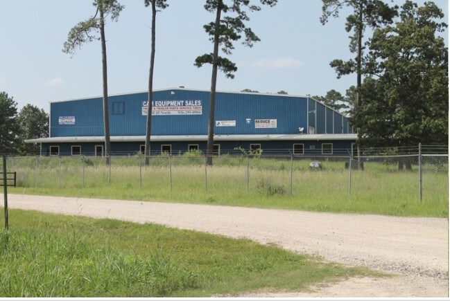
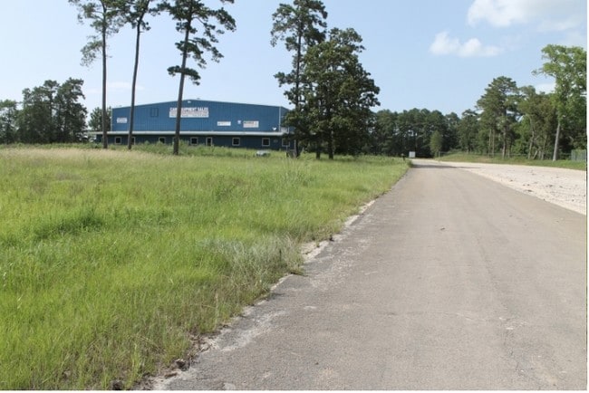
Property Record
790 Interstate 45 S, Huntsville, TX 77340

Property Detail
790 Interstate 45 S
11686
CRABB H M (A-15), TRACT 27.2, ACRES 10.78
Commercialnec
WALKER
B and X Area of moderate flood hazard, usually the area between the limits of the 100-year and 500-year floods.
Texas
2024
10.78 AC
2025
Texas East Area
790700
Other Market Areas
92,920 SF
Huntsville, TX
NEARBY LISTINGS FOR SALE OR LEASE
-
-
View all Huntsville listings for sale on LoopNet.com
DEMOGRAPHICS near 790 Interstate 45 S
1 mile
3 mile
5 mile
2025 Total Population
906
4,224
31,269
2030 Population
975
4,447
32,912
Pop Growth 2025-2030
+ 7.62%
+ 5.28%
+ 5.25%
Average Age
41
39
34
2025 Total Households
363
1,823
11,277
HH Growth 2025-2030
+ 8.82%
+ 6.14%
+ 6.35%
Median Household Inc
$72,655
$51,487
$40,526
Avg Household Size
2.50
2.30
2.20
2025 Avg HH Vehicles
2.00
2.00
2.00
Median Home Value
$230,701
$244,466
$222,761
Median Year Built
2005
1989
1989
Nearby Places
Map Layers
Map Styles
 Street
 Aerial
Layers
 Traffic
 Biking
Places
Listings with unknown addresses are not visible on the map
- Restaurants
- Banks
- Shops
- Fitness
- Groceries
SALE & LEASE HISTORY
LISTING DATE
SALE/LEASE

Jul 26, 2018
For Sale
Nearby Properties
Address
Land Use
TOTAL SIZE
Lot Size
Zoning
Address
Land Use
TOTAL SIZE
Lot Size
Zoning
316,247 SF
320.50 AC
Address
Land Use
TOTAL SIZE
Lot Size
Zoning
178,134 SF
12.60 AC
Address
Land Use
TOTAL SIZE
Lot Size
Zoning
720 SF
14.68 AC
Address
Land Use
TOTAL SIZE
Lot Size
Zoning
40,142 SF
7.05 AC
Address
Land Use
TOTAL SIZE
Lot Size
Zoning
346,645 SF
72.55 AC
Address
Land Use
TOTAL SIZE
Lot Size
Zoning
152,146 SF
6.51 AC
Address
Land Use
TOTAL SIZE
Lot Size
Zoning
1,834 SF
9.19 AC
Address
Land Use
TOTAL SIZE
Lot Size
Zoning
118,327 SF
5 AC
Address
Land Use
TOTAL SIZE
Lot Size
Zoning
495,743 SF
11.96 AC
Address
Land Use
TOTAL SIZE
Lot Size
Zoning
172,785 SF
15.72 AC
Address
Land Use
TOTAL SIZE
Lot Size
Zoning
221,122 SF
14.47 AC
Address
Land Use
TOTAL SIZE
Lot Size
Zoning
92,672 SF
4.91 AC
Address
Land Use
TOTAL SIZE
Lot Size
Zoning
188,700 SF
103.89 AC
Address
Land Use
TOTAL SIZE
Lot Size
Zoning
34,321 SF
7.82 AC
Address
Land Use
TOTAL SIZE
Lot Size
Zoning
Address
Land Use
TOTAL SIZE
Lot Size
Zoning
2,631 SF
210.01 AC
Address
Land Use
TOTAL SIZE
Lot Size
Zoning
99,978 SF
9.97 AC
Address
Land Use
TOTAL SIZE
Lot Size
Zoning
771,540 SF
52.56 AC
Address
Land Use
TOTAL SIZE
Lot Size
Zoning
206,442 SF
7.50 AC
Address
Land Use
TOTAL SIZE
Lot Size
Zoning
Address
Land Use
TOTAL SIZE
Lot Size
Zoning
80,728 SF
Address
Land Use
TOTAL SIZE
Lot Size
Zoning
Address
Land Use
TOTAL SIZE
Lot Size
Zoning
268,624 SF
10.24 AC
Address
Land Use
TOTAL SIZE
Lot Size
Zoning
81,291 SF
9 AC
Address
Land Use
TOTAL SIZE
Lot Size
Zoning
19,560 SF
10.62 AC
Address
Land Use
TOTAL SIZE
Lot Size
Zoning
111,751 SF
6 AC
Address
Land Use
TOTAL SIZE
Lot Size
Zoning
Address
Land Use
TOTAL SIZE
Lot Size
Zoning
5,400 SF
1.90 AC
Address
Land Use
TOTAL SIZE
Lot Size
Zoning
9,393 SF
124.25 AC
Address
Land Use
TOTAL SIZE
Lot Size
Zoning
186 SF
3.92 AC
The World's #1 Commercial Real Estate Marketplace
Connect with us
© 2026 CoStar Group
The information above has been obtained from sources believed reliable. While we do not doubt its accuracy we have not verified it and make no guarantee, warranty or representation about it. It is your responsibility to independently confirm its accuracy and completeness. Any projections, opinions, assumptions, or estimates used are for example only and do not represent the current or future performance of the property. The value of this transaction to you depends on tax and other factors which should be evaluated by your tax, financial, and legal advisors. You and your advisors should conduct a careful, independent investigation of the property to determine to your satisfaction the suitability of the property for your needs.