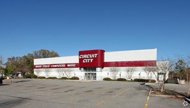
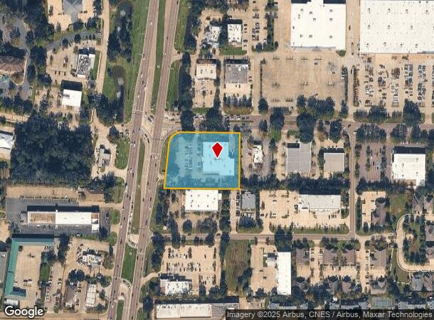
Property Record
790 N Highway 190, Covington, LA 70433

NEARBY LISTINGS FOR SALE OR LEASE
Property Detail
790 N Highway 190
Slidell-Mandeville-Covington, LA
Commercial N Hwy 190
28799
LOT 7A BEING A RESUB OF LOTS 7 8 CONT 2.0825 ACS ST TAMMANY OAKS SUB CB 288 567 CB 253 112 INST NO 943891 INST NO 1045860 INS
Commercialnec
St Tammany
ARE
Louisiana
2025
7
2024
2.08 AC
040609
Mandeville/Covington
21,956 SF
New Orleans/Metairie/Kenner
DEMOGRAPHICS near 790 N Highway 190
1 mile
3 mile
5 mile
2024 Total Population
6,128
34,845
88,101
2029 Population
6,589
37,599
94,688
Pop Growth 2024-2029
+ 7.52%
+ 7.90%
+ 7.48%
Average Age
41
42
41
2024 Total Households
2,649
14,156
34,834
HH Growth 2024-2029
+ 7.25%
+ 7.88%
+ 7.48%
Median Household Inc
$73,248
$75,507
$74,958
Avg Household Size
2.30
2.40
2.50
2024 Avg HH Vehicles
2.00
2.00
2.00
Median Home Value
$293,187
$293,886
$308,760
Median Year Built
2001
1996
1995
Nearby Places
Map Layers
Map Styles
 Street
 Aerial
Transit
 Traffic
 Biking
Places
Listings with unknown addresses are not visible on the map
- Restaurants
- Banks
- Shops
- Fitness
- Groceries
PUBLIC TRANSPORTATION
AIRPORT
Louis Armstrong New Orleans International
Drive
Walk
Distance
Louis Armstrong New Orleans International
53 min
39.4 mi
Freight Ports
Port of New Orleans
Drive
Walk
Distance
Port of New Orleans
57 min
40.4 mi
Nearby Properties
Address
Land Use
TOTAL SIZE
Lot Size
Zoning
Address
Land Use
TOTAL SIZE
Lot Size
Zoning
515,547 SF
20.54 AC
Address
Land Use
TOTAL SIZE
Lot Size
Zoning
13.36 AC
Address
Land Use
TOTAL SIZE
Lot Size
Zoning
285,406 SF
Address
Land Use
TOTAL SIZE
Lot Size
Zoning
178,608 SF
34.02 AC
Address
Land Use
TOTAL SIZE
Lot Size
Zoning
200,000 SF
0.28 AC
Address
Land Use
TOTAL SIZE
Lot Size
Zoning
5.10 AC
Address
Land Use
TOTAL SIZE
Lot Size
Zoning
262,080 SF
12.29 AC
Address
Land Use
TOTAL SIZE
Lot Size
Zoning
218,240 SF
23.82 AC
Address
Land Use
TOTAL SIZE
Lot Size
Zoning
24.12 AC
Address
Land Use
TOTAL SIZE
Lot Size
Zoning
168,000 SF
10 AC
Address
Land Use
TOTAL SIZE
Lot Size
Zoning
86,167 SF
0.71 AC
Address
Land Use
TOTAL SIZE
Lot Size
Zoning
68,478 SF
6.64 AC
Address
Land Use
TOTAL SIZE
Lot Size
Zoning
66,500 SF
4.35 AC
Address
Land Use
TOTAL SIZE
Lot Size
Zoning
102,470 SF
10.50 AC
Address
Land Use
TOTAL SIZE
Lot Size
Zoning
57,360 SF
2.77 AC
Address
Land Use
TOTAL SIZE
Lot Size
Zoning
205,612 SF
23.60 AC
Address
Land Use
TOTAL SIZE
Lot Size
Zoning
147,611 SF
22 AC
Address
Land Use
TOTAL SIZE
Lot Size
Zoning
131,925 SF
2.02 AC
Address
Land Use
TOTAL SIZE
Lot Size
Zoning
38,976 SF
6.80 AC
Address
Land Use
TOTAL SIZE
Lot Size
Zoning
154,208 SF
21.28 AC
Address
Land Use
TOTAL SIZE
Lot Size
Zoning
92,535 SF
2.80 AC
Address
Land Use
TOTAL SIZE
Lot Size
Zoning
114,823 SF
4.57 AC
Address
Land Use
TOTAL SIZE
Lot Size
Zoning
124,002 SF
20.55 AC
Address
Land Use
TOTAL SIZE
Lot Size
Zoning
145,663 SF
16.70 AC
Address
Land Use
TOTAL SIZE
Lot Size
Zoning
86,688 SF
3.75 AC
Address
Land Use
TOTAL SIZE
Lot Size
Zoning
114,727 SF
4.46 AC
Address
Land Use
TOTAL SIZE
Lot Size
Zoning
Address
Land Use
TOTAL SIZE
Lot Size
Zoning
48,866 SF
2.21 AC
Address
Land Use
TOTAL SIZE
Lot Size
Zoning
126 SF
2.55 AC
Address
Land Use
TOTAL SIZE
Lot Size
Zoning
70,689 SF
2.90 AC
The World's #1 Commercial Real Estate Marketplace
Connect with us
© 2026 CoStar Group
The information above has been obtained from sources believed reliable. While we do not doubt its accuracy we have not verified it and make no guarantee, warranty or representation about it. It is your responsibility to independently confirm its accuracy and completeness. Any projections, opinions, assumptions, or estimates used are for example only and do not represent the current or future performance of the property. The value of this transaction to you depends on tax and other factors which should be evaluated by your tax, financial, and legal advisors. You and your advisors should conduct a careful, independent investigation of the property to determine to your satisfaction the suitability of the property for your needs.