Property Record
7900 Brevard Rd, Etowah, NC 28729
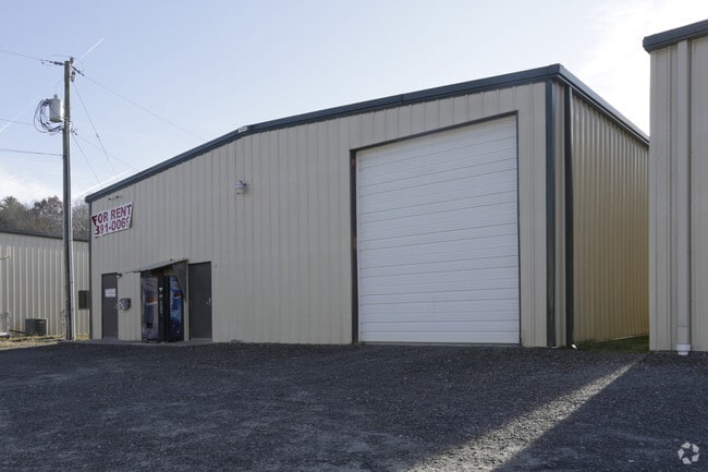

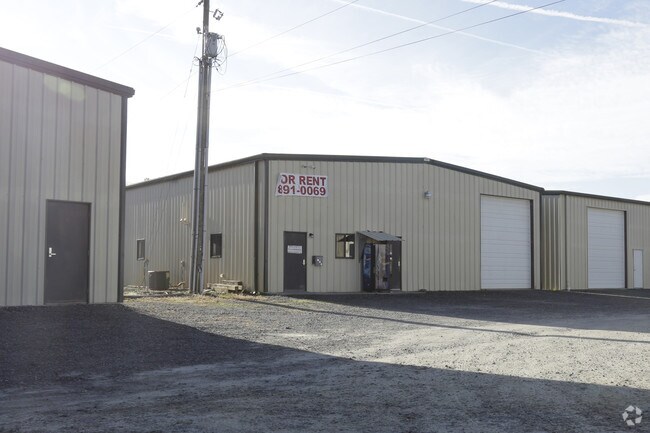
Property Detail
7900 Brevard Rd
9964986
US64 ON
Autorepair
Henderson
9964986~CC
North Carolina
AE The base floodplain where base flood elevations are provided. AE Zones are now used on new format FIRMs instead of A1-A30 Zones.
5751
2025
7.78 AC
2025
Henderson County
930703
Asheville
7,422 SF
Asheville, NC
NEARBY LISTINGS FOR SALE OR LEASE
-
-
View all Etowah listings for sale on LoopNet.com
DEMOGRAPHICS near 7900 Brevard Rd
1 mile
3 mile
5 mile
2025 Total Population
1,655
8,656
18,531
2030 Population
1,693
8,811
18,966
Pop Growth 2025-2030
+ 2.30%
+ 1.79%
+ 2.35%
Average Age
48
46
47
2025 Total Households
723
3,674
7,823
HH Growth 2025-2030
+ 2.49%
+ 1.93%
+ 2.52%
Median Household Inc
$57,559
$63,154
$67,985
Avg Household Size
2.30
2.30
2.30
2025 Avg HH Vehicles
2.00
2.00
2.00
Median Home Value
$341,338
$340,528
$376,175
Median Year Built
1995
1991
1990
Nearby Places
Map Layers
Map Styles
 Street
 Aerial
Layers
 Traffic
 Biking
Places
Listings with unknown addresses are not visible on the map
- Restaurants
- Banks
- Shops
- Fitness
- Groceries
PUBLIC TRANSPORTATION
AIRPORT
Asheville Regional
Drive
Walk
Distance
Asheville Regional
22 min
13.9 mi
Freight Ports
North Charleston Terminal
Drive
Walk
Distance
North Charleston Terminal
284 min
247.3 mi
Nearby Properties
Address
Land Use
TOTAL SIZE
Lot Size
Zoning
Address
Land Use
TOTAL SIZE
Lot Size
Zoning
35.90 AC
10005135~R
Address
Land Use
TOTAL SIZE
Lot Size
Zoning
43,839 SF
10.87 AC
9933934~R1
Address
Land Use
TOTAL SIZE
Lot Size
Zoning
6,955 SF
173.84 AC
9963128~R1
Address
Land Use
TOTAL SIZE
Lot Size
Zoning
13,600 SF
4.43 AC
10012116~C
Address
Land Use
TOTAL SIZE
Lot Size
Zoning
40,940 SF
7.39 AC
9928960~CC
Address
Land Use
TOTAL SIZE
Lot Size
Zoning
4,626 SF
2.14 AC
Address
Land Use
TOTAL SIZE
Lot Size
Zoning
21,395 SF
10.09 AC
Address
Land Use
TOTAL SIZE
Lot Size
Zoning
4,250 SF
3.67 AC
10007980~C
Address
Land Use
TOTAL SIZE
Lot Size
Zoning
23,112 SF
9.55 AC
9902435~I
Address
Land Use
TOTAL SIZE
Lot Size
Zoning
44,884 SF
4.55 AC
1018998~CC
Address
Land Use
TOTAL SIZE
Lot Size
Zoning
6,553 SF
3.06 AC
Address
Land Use
TOTAL SIZE
Lot Size
Zoning
4,281 SF
88.88 AC
1008348~R2
Address
Land Use
TOTAL SIZE
Lot Size
Zoning
16,620 SF
2.76 AC
9933590~R1
Address
Land Use
TOTAL SIZE
Lot Size
Zoning
8,048 SF
2.30 AC
1003374~CC
Address
Land Use
TOTAL SIZE
Lot Size
Zoning
56,440 SF
5.16 AC
401929~R2R
Address
Land Use
TOTAL SIZE
Lot Size
Zoning
10,126 SF
3.07 AC
9974230~CC
Address
Land Use
TOTAL SIZE
Lot Size
Zoning
18,212 SF
0.87 AC
9933816~LC
Address
Land Use
TOTAL SIZE
Lot Size
Zoning
1,920 SF
1.96 AC
Address
Land Use
TOTAL SIZE
Lot Size
Zoning
2,876 SF
20.46 AC
Address
Land Use
TOTAL SIZE
Lot Size
Zoning
12,000 SF
8.30 AC
Address
Land Use
TOTAL SIZE
Lot Size
Zoning
2,334 SF
5.11 AC
9933856~R1
Address
Land Use
TOTAL SIZE
Lot Size
Zoning
1,200 SF
10.36 AC
9933823~I
Address
Land Use
TOTAL SIZE
Lot Size
Zoning
8,466 SF
11.03 AC
Address
Land Use
TOTAL SIZE
Lot Size
Zoning
3,936 SF
2.46 AC
1008415~CC
Address
Land Use
TOTAL SIZE
Lot Size
Zoning
8,100 SF
6.72 AC
Address
Land Use
TOTAL SIZE
Lot Size
Zoning
12,808 SF
2.71 AC
Address
Land Use
TOTAL SIZE
Lot Size
Zoning
19,880 SF
1.21 AC
10007979~C
Address
Land Use
TOTAL SIZE
Lot Size
Zoning
3,900 SF
5.93 AC
9905114~MR
Address
Land Use
TOTAL SIZE
Lot Size
Zoning
7,304 SF
1.90 AC
10007087~C
The World's #1 Commercial Real Estate Marketplace
Connect with us
© 2026 CoStar Group
The information above has been obtained from sources believed reliable. While we do not doubt its accuracy we have not verified it and make no guarantee, warranty or representation about it. It is your responsibility to independently confirm its accuracy and completeness. Any projections, opinions, assumptions, or estimates used are for example only and do not represent the current or future performance of the property. The value of this transaction to you depends on tax and other factors which should be evaluated by your tax, financial, and legal advisors. You and your advisors should conduct a careful, independent investigation of the property to determine to your satisfaction the suitability of the property for your needs.