Property Record
7900 Knights Dr, El Paso, TX 79915


NEARBY LISTINGS FOR SALE OR LEASE
-
-
View all El Paso listings for sale on LoopNet.com
Property Detail
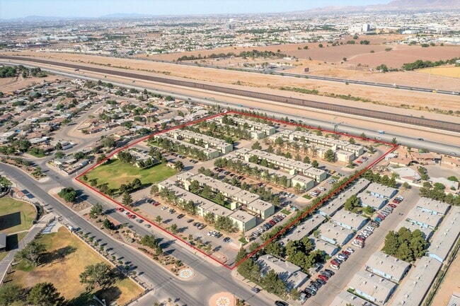
7900 Knights Dr
El Paso, TX
A Thomas Manor
T240-999-000H-3300
H THOMAS MANOR #7 LOT 22 (516489 SQ FT)
Apartment
El Paso
AH
Texas
4802140044C
22
0
11.86 AC
2025
Thomas Manor
003801
El Paso
174,320 SF
DEMOGRAPHICS near 7900 Knights Dr
1 Mile
3 Mile
5 Mile
2024 Total Population
7,104
63,672
170,753
2029 Population
7,144
64,258
172,172
Pop Growth 2024-2029
+ 0.56%
+ 0.92%
+ 0.83%
Average Age
42
40
40
2024 Total Households
2,556
23,336
63,682
HH Growth 2024-2029
+ 0.59%
+ 0.91%
+ 0.82%
Median Household Inc
$35,448
$35,907
$40,164
Avg Household Size
2.70
2.70
2.60
2024 Avg HH Vehicles
2.00
2.00
2.00
Median Home Value
$116,835
$110,957
$134,157
Median Year Built
1968
1969
1973
Nearby Places
Map Layers
Map Styles
 Street
 Aerial
- Restaurants
- Banks
- Shops
- Fitness
- Groceries
PUBLIC TRANSPORTATION
AIRPORT
El Paso International
DRIVE
WALK
Distance
El Paso International
25 min
11.4 mi
Freight Ports
Port of Corpus Christi
DRIVE
WALK
Distance
Port of Corpus Christi
676 min
689.3 mi
SALE & LEASE HISTORY
LISTING DATE
SALE/LEASE

Jul 26, 2021
For Sale
Nearby Properties
Address
Land Use
TOTAL SIZE
Lot Size
Zoning
Address
Land Use
TOTAL SIZE
Lot Size
Zoning
600,211 SF
114.73 AC
RF
Address
Land Use
TOTAL SIZE
Lot Size
Zoning
1 SF
M1
Address
Land Use
TOTAL SIZE
Lot Size
Zoning
1 SF
214 AC
M3
Address
Land Use
TOTAL SIZE
Lot Size
Zoning
1 SF
Address
Land Use
TOTAL SIZE
Lot Size
Zoning
377,168 SF
8.40 AC
C1
Address
Land Use
TOTAL SIZE
Lot Size
Zoning
125,896 SF
8.67 AC
R3
Address
Land Use
TOTAL SIZE
Lot Size
Zoning
206,726 SF
24.42 AC
M1S
Address
Land Use
TOTAL SIZE
Lot Size
Zoning
269,974 SF
15.87 AC
A2S
Address
Land Use
TOTAL SIZE
Lot Size
Zoning
109,578 SF
17.84 AC
RF
Address
Land Use
TOTAL SIZE
Lot Size
Zoning
341,541 SF
22.51 AC
A2
Address
Land Use
TOTAL SIZE
Lot Size
Zoning
307,575 SF
37.26 AC
Address
Land Use
TOTAL SIZE
Lot Size
Zoning
139,470 SF
11.33 AC
C3
Address
Land Use
TOTAL SIZE
Lot Size
Zoning
153,159 SF
11.86 AC
C1
Address
Land Use
TOTAL SIZE
Lot Size
Zoning
136,526 SF
10.97 AC
C3
Address
Land Use
TOTAL SIZE
Lot Size
Zoning
132,336 SF
12.12 AC
A2
Address
Land Use
TOTAL SIZE
Lot Size
Zoning
103,116 SF
7.44 AC
C3
Address
Land Use
TOTAL SIZE
Lot Size
Zoning
198,136 SF
12.03 AC
C4S
Address
Land Use
TOTAL SIZE
Lot Size
Zoning
153,050 SF
9.89 AC
A2
Address
Land Use
TOTAL SIZE
Lot Size
Zoning
83,785 SF
11.19 AC
R3
Address
Land Use
TOTAL SIZE
Lot Size
Zoning
60,505 SF
3.78 AC
C1
Address
Land Use
TOTAL SIZE
Lot Size
Zoning
35,732 SF
345.97 AC
R4
Address
Land Use
TOTAL SIZE
Lot Size
Zoning
157,162 SF
5.57 AC
A2S
Address
Land Use
TOTAL SIZE
Lot Size
Zoning
93,981 SF
47.24 AC
R4
Address
Land Use
TOTAL SIZE
Lot Size
Zoning
276,025 SF
15.01 AC
M1
Address
Land Use
TOTAL SIZE
Lot Size
Zoning
100,100 SF
5.74 AC
M1S
Address
Land Use
TOTAL SIZE
Lot Size
Zoning
76,966 SF
6.66 AC
C3
Address
Land Use
TOTAL SIZE
Lot Size
Zoning
128,555 SF
15.92 AC
C4
Address
Land Use
TOTAL SIZE
Lot Size
Zoning
32,180 SF
5.78 AC
C4
Address
Land Use
TOTAL SIZE
Lot Size
Zoning
118,400 SF
10.88 AC
M1
The World's #1 Commercial Real Estate Marketplace
Connect with us
© 2025 CoStar Group
The information above has been obtained from sources believed reliable. While we do not doubt its accuracy we have not verified it and make no guarantee, warranty or representation about it. It is your responsibility to independently confirm its accuracy and completeness. Any projections, opinions, assumptions, or estimates used are for example only and do not represent the current or future performance of the property. The value of this transaction to you depends on tax and other factors which should be evaluated by your tax, financial, and legal advisors. You and your advisors should conduct a careful, independent investigation of the property to determine to your satisfaction the suitability of the property for your needs.