Property Record
7900 Old York Rd, Elkins Park, PA 19027
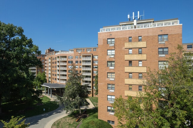
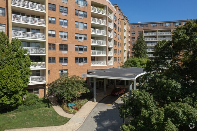
This Property Is For Sale
NEARBY LISTINGS FOR SALE OR LEASE
Property Detail
7900 Old York Rd
Philadelphia-Camden-Wilmington, PA-NJ-DE-MD
Elkins Park House Condo
31-00-30005-771
C-1
Condominium
Montgomery
X
Pennsylvania
42091C0384G
235
2024
0.03 AC
2025
Elkins Park
202302
Philadelphia
1,472 SF
DEMOGRAPHICS near 7900 Old York Rd
1 Mile
3 Mile
5 Mile
2024 Total Population
16,793
234,033
617,764
2029 Population
17,212
228,922
600,206
Pop Growth 2024-2029
+ 2.50%
(2.18%)
(2.84%)
Average Age
42
41
40
2024 Total Households
7,293
92,793
235,445
HH Growth 2024-2029
+ 2.87%
(2.28%)
(2.93%)
Median Household Inc
$81,534
$59,436
$56,627
Avg Household Size
2.20
2.40
2.50
2024 Avg HH Vehicles
1.00
1.00
1.00
Median Home Value
$336,697
$220,711
$227,362
Median Year Built
1952
1951
1951
Nearby Places
- Restaurants
- Banks
- Shops
- Fitness
- Groceries
PUBLIC TRANSPORTATION
COMMUTER RAIL
Elkins Park (R1 - Southeastern Pennsylvania Transportation Authority Regional Rail (SEPTA Regional Rail), R2 - Southeastern Pennsylvania Transportation Authority Regional Rail (SEPTA Regional Rail), R3 - Southeastern Pennsylvania Transportation Authority Regional Rail (SEPTA Regional Rail), R5 - Southeastern Pennsylvania Transportation Authority Regional Rail (SEPTA Regional Rail))
DRIVE
WALK
Distance
Elkins Park (R1 - Southeastern Pennsylvania Transportation Authority Regional Rail (SEPTA Regional Rail), R2 - Southeastern Pennsylvania Transportation Authority Regional Rail (SEPTA Regional Rail), R3 - Southeastern Pennsylvania Transportation Authority Regional Rail (SEPTA Regional Rail), R5 - Southeastern Pennsylvania Transportation Authority Regional Rail (SEPTA Regional Rail))
2 min
8 min
0.4 mi
Melrose Park (R1 - Southeastern Pennsylvania Transportation Authority Regional Rail (SEPTA Regional Rail), R2 - Southeastern Pennsylvania Transportation Authority Regional Rail (SEPTA Regional Rail), R3 - Southeastern Pennsylvania Transportation Authority Regional Rail (SEPTA Regional Rail), R5 - Southeastern Pennsylvania Transportation Authority Regional Rail (SEPTA Regional Rail))
DRIVE
WALK
Distance
Melrose Park (R1 - Southeastern Pennsylvania Transportation Authority Regional Rail (SEPTA Regional Rail), R2 - Southeastern Pennsylvania Transportation Authority Regional Rail (SEPTA Regional Rail), R3 - Southeastern Pennsylvania Transportation Authority Regional Rail (SEPTA Regional Rail), R5 - Southeastern Pennsylvania Transportation Authority Regional Rail (SEPTA Regional Rail))
4 min
1.4 mi
AIRPORT
Philadelphia International
DRIVE
WALK
Distance
Philadelphia International
38 min
22.5 mi
Trenton Mercer
DRIVE
WALK
Distance
Trenton Mercer
47 min
28.1 mi
Nearby Properties
Address
Land Use
TOTAL SIZE
Lot Size
Zoning
Address
Land Use
TOTAL SIZE
Lot Size
Zoning
2,146,150 SF
119.95 AC
M1
Address
Land Use
TOTAL SIZE
Lot Size
Zoning
287,286 SF
1.26 AC
CMX5
Address
Land Use
TOTAL SIZE
Lot Size
Zoning
290,454 SF
58.56 AC
RSA1
Address
Land Use
TOTAL SIZE
Lot Size
Zoning
107,391 SF
13.68 AC
SPINS
Address
Land Use
TOTAL SIZE
Lot Size
Zoning
649,400 SF
55.03 AC
R1
Address
Land Use
TOTAL SIZE
Lot Size
Zoning
504,972 SF
16.30 AC
RM2
Address
Land Use
TOTAL SIZE
Lot Size
Zoning
238,378 SF
18 AC
CA1
Address
Land Use
TOTAL SIZE
Lot Size
Zoning
2,500,000 SF
134.14 AC
I2
Address
Land Use
TOTAL SIZE
Lot Size
Zoning
487,936 SF
58.50 AC
T
Address
Land Use
TOTAL SIZE
Lot Size
Zoning
526,165 SF
12.68 AC
RSA3
Address
Land Use
TOTAL SIZE
Lot Size
Zoning
28,239 SF
1.48 AC
SPINS
Address
Land Use
TOTAL SIZE
Lot Size
Zoning
16,832 SF
65.87 AC
SPPOA
Address
Land Use
TOTAL SIZE
Lot Size
Zoning
363,136 SF
16.47 AC
RSA3
Address
Land Use
TOTAL SIZE
Lot Size
Zoning
233,143 SF
24.24 AC
SPINS
Address
Land Use
TOTAL SIZE
Lot Size
Zoning
281,012 SF
32.58 AC
RSA5
Address
Land Use
TOTAL SIZE
Lot Size
Zoning
705,687 SF
19.89 AC
C1
Address
Land Use
TOTAL SIZE
Lot Size
Zoning
635,387 SF
10.12 AC
C1
Address
Land Use
TOTAL SIZE
Lot Size
Zoning
3,104 SF
0.09 AC
RSA2
Address
Land Use
TOTAL SIZE
Lot Size
Zoning
316,163 SF
45.32 AC
T
Address
Land Use
TOTAL SIZE
Lot Size
Zoning
557,091 SF
21.87 AC
AO
Address
Land Use
TOTAL SIZE
Lot Size
Zoning
171,000 SF
23 AC
RM1
Address
Land Use
TOTAL SIZE
Lot Size
Zoning
582,294 SF
9.07 AC
C1
Address
Land Use
TOTAL SIZE
Lot Size
Zoning
103,131 SF
0.19 AC
CMX3
Address
Land Use
TOTAL SIZE
Lot Size
Zoning
615,217 SF
33.52 AC
C2
Address
Land Use
TOTAL SIZE
Lot Size
Zoning
182,130 SF
6.45 AC
RSA3
Address
Land Use
TOTAL SIZE
Lot Size
Zoning
243,889 SF
20.89 AC
CA2
Address
Land Use
TOTAL SIZE
Lot Size
Zoning
180,066 SF
59.77 AC
RSA3
Address
Land Use
TOTAL SIZE
Lot Size
Zoning
88,400 SF
1.79 AC
CMX2
Address
Land Use
TOTAL SIZE
Lot Size
Zoning
336,650 SF
61.74 AC
R3
Address
Land Use
TOTAL SIZE
Lot Size
Zoning
168,357 SF
5.37 AC
RM1
The World's #1 Commercial Real Estate Marketplace
Connect with us
© 2025 CoStar Group
The information above has been obtained from sources believed reliable. While we do not doubt its accuracy we have not verified it and make no guarantee, warranty or representation about it. It is your responsibility to independently confirm its accuracy and completeness. Any projections, opinions, assumptions, or estimates used are for example only and do not represent the current or future performance of the property. The value of this transaction to you depends on tax and other factors which should be evaluated by your tax, financial, and legal advisors. You and your advisors should conduct a careful, independent investigation of the property to determine to your satisfaction the suitability of the property for your needs.