Property Record
7900 Stonewall Shops Sq, Gainesville, VA 20155


Save to a Folder
{{folder.Name}}
{{folder.ListingIds.length}} Properties
{{folder.ListingIds.length}} Property
Create a New Folder
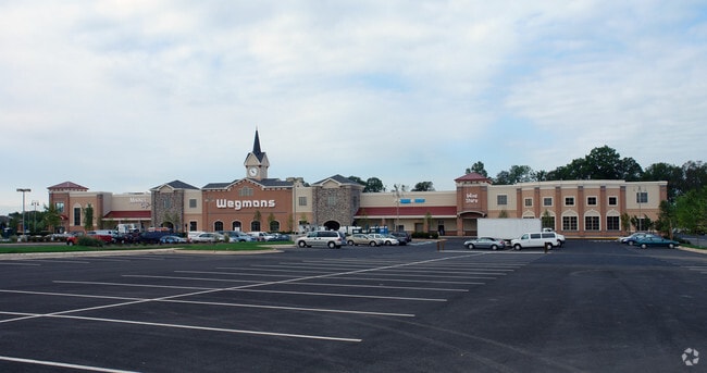
Property Detail
7900 Stonewall Shops Sq
7296-49-9598
THE SHOPS AT STONEWALL PCL A1
Regionalshoppingcenterormallwithanchorstore
PRINCE WILLIAM
RPC
Virginia
B and X Area of moderate flood hazard, usually the area between the limits of the 100-year and 500-year floods.
9598
2024
37.06 AC
2025
Route 29/I-66 Corridor
901507
Washington, DC
333,737 SF
Washington-Arlington-Alexandria, DC-VA-MD-WV
NEARBY LISTINGS FOR SALE OR LEASE
DEMOGRAPHICS near 7900 Stonewall Shops Sq
1 mile
3 mile
5 mile
2025 Total Population
4,081
39,532
85,775
2030 Population
4,278
40,830
88,262
Pop Growth 2025-2030
+ 4.83%
+ 3.28%
+ 2.90%
Average Age
41
37
40
2025 Total Households
1,251
12,181
27,381
HH Growth 2025-2030
+ 4.80%
+ 3.23%
+ 2.85%
Median Household Inc
$194,530
$171,502
$176,038
Avg Household Size
3.10
3.20
3.10
2025 Avg HH Vehicles
3.00
2.00
2.00
Median Home Value
$818,704
$694,153
$709,279
Median Year Built
2007
2005
2004
Nearby Places
Map Layers
Map Styles
 Street
 Aerial
Layers
 Traffic
 Biking
Places
Listings with unknown addresses are not visible on the map
- Restaurants
- Banks
- Shops
- Fitness
- Groceries
PUBLIC TRANSPORTATION
AIRPORT
Washington Dulles International
Drive
Walk
Distance
Washington Dulles International
39 min
24.6 mi
Freight Ports
Port of Baltimore
Drive
Walk
Distance
Port of Baltimore
98 min
75.0 mi
Nearby Properties
Address
Land Use
TOTAL SIZE
Lot Size
Zoning
Address
Land Use
TOTAL SIZE
Lot Size
Zoning
453,174 SF
38.50 AC
PBD
Address
Land Use
TOTAL SIZE
Lot Size
Zoning
560,942 SF
90.90 AC
B1
Address
Land Use
TOTAL SIZE
Lot Size
Zoning
252,966 SF
10.54 AC
PMD
Address
Land Use
TOTAL SIZE
Lot Size
Zoning
220,552 SF
30.95 AC
PMD
Address
Land Use
TOTAL SIZE
Lot Size
Zoning
236,082 SF
28.27 AC
M2
Address
Land Use
TOTAL SIZE
Lot Size
Zoning
75,317 SF
13.68 AC
R16
Address
Land Use
TOTAL SIZE
Lot Size
Zoning
241,328 SF
8.66 AC
B1
Address
Land Use
TOTAL SIZE
Lot Size
Zoning
84,199 SF
8.57 AC
PLANNED CO
Address
Land Use
TOTAL SIZE
Lot Size
Zoning
92,182 SF
19.90 AC
B1
Address
Land Use
TOTAL SIZE
Lot Size
Zoning
18.22 AC
A1
Address
Land Use
TOTAL SIZE
Lot Size
Zoning
Address
Land Use
TOTAL SIZE
Lot Size
Zoning
285,889 SF
19.61 AC
M1
Address
Land Use
TOTAL SIZE
Lot Size
Zoning
125,653 SF
19.78 AC
MIXED
Address
Land Use
TOTAL SIZE
Lot Size
Zoning
80,141 SF
8.67 AC
B1
Address
Land Use
TOTAL SIZE
Lot Size
Zoning
107,175 SF
6.96 AC
RPC
Address
Land Use
TOTAL SIZE
Lot Size
Zoning
99,391 SF
24.31 AC
SR1
Address
Land Use
TOTAL SIZE
Lot Size
Zoning
158,198 SF
7.13 AC
M1
Address
Land Use
TOTAL SIZE
Lot Size
Zoning
89,949 SF
15 AC
R4
Address
Land Use
TOTAL SIZE
Lot Size
Zoning
128,240 SF
10.06 AC
PMD
Address
Land Use
TOTAL SIZE
Lot Size
Zoning
97,037 SF
11.69 AC
B1
Address
Land Use
TOTAL SIZE
Lot Size
Zoning
104,161 SF
38.96 AC
A1
Address
Land Use
TOTAL SIZE
Lot Size
Zoning
136,530 SF
1.98 AC
M1
Address
Land Use
TOTAL SIZE
Lot Size
Zoning
133,296 SF
6.24 AC
M2
Address
Land Use
TOTAL SIZE
Lot Size
Zoning
81,462 SF
PMD
Address
Land Use
TOTAL SIZE
Lot Size
Zoning
65,405 SF
7.37 AC
RPC
Address
Land Use
TOTAL SIZE
Lot Size
Zoning
39,927 SF
9.32 AC
PMD
Address
Land Use
TOTAL SIZE
Lot Size
Zoning
160,480 SF
12.75 AC
PMD
Address
Land Use
TOTAL SIZE
Lot Size
Zoning
38,896 SF
20.35 AC
OM
Address
Land Use
TOTAL SIZE
Lot Size
Zoning
71,888 SF
27.74 AC
RES, 1 DWE
The World's #1 Commercial Real Estate Marketplace
Connect with us
© 2026 CoStar Group
The information above has been obtained from sources believed reliable. While we do not doubt its accuracy we have not verified it and make no guarantee, warranty or representation about it. It is your responsibility to independently confirm its accuracy and completeness. Any projections, opinions, assumptions, or estimates used are for example only and do not represent the current or future performance of the property. The value of this transaction to you depends on tax and other factors which should be evaluated by your tax, financial, and legal advisors. You and your advisors should conduct a careful, independent investigation of the property to determine to your satisfaction the suitability of the property for your needs.