Property Record
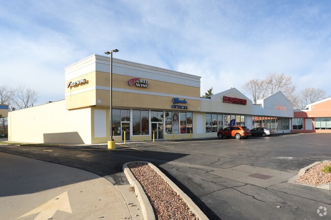
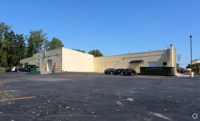
7901-7915 Brewerton Rd, Cicero, NY 13039

NEARBY LISTINGS FOR SALE OR LEASE
Property Detail
7901-7915 Brewerton Rd
312289-037-000-0001-018-001-0000
FL 66 1149135
Stripcommercialcenter
Onondaga
X
New York
36067C0094F
18.001
2025
3.16 AC
2024
NE Outer Onondaga County
010301
Syracuse
32,370 SF
Syracuse, NY
DEMOGRAPHICS near 7901-7915 Brewerton Rd
1 Mile
3 Mile
5 Mile
2024 Total Population
4,919
40,716
82,795
2029 Population
4,760
39,503
80,506
Pop Growth 2024-2029
(3.23%)
(2.98%)
(2.76%)
Average Age
41
43
42
2024 Total Households
2,015
16,902
34,970
HH Growth 2024-2029
(3.42%)
(3.15%)
(2.95%)
Median Household Inc
$74,670
$83,283
$74,676
Avg Household Size
2.40
2.40
2.30
2024 Avg HH Vehicles
2.00
2.00
2.00
Median Home Value
$151,774
$167,619
$164,881
Median Year Built
1969
1971
1970
Nearby Places
Map Layers
Map Styles
 Street
 Aerial
- Restaurants
- Banks
- Shops
- Fitness
- Groceries
PUBLIC TRANSPORTATION
COMMUTER RAIL
DRIVE
WALK
Distance
13 min
8.1 mi
DRIVE
WALK
Distance
13 min
8.1 mi
AIRPORT
Syracuse Hancock International
DRIVE
WALK
Distance
Syracuse Hancock International
11 min
5.3 mi
SALE & LEASE HISTORY
LISTING DATE
SALE/LEASE

Nov 15, 2017
For Lease
Nov 11, 2016
For Lease
Nearby Properties
Address
Land Use
TOTAL SIZE
Lot Size
Zoning
Address
Land Use
TOTAL SIZE
Lot Size
Zoning
256,727 SF
70.21 AC
Address
Land Use
TOTAL SIZE
Lot Size
Zoning
439,670 SF
74.73 AC
C-G
Address
Land Use
TOTAL SIZE
Lot Size
Zoning
157,010 SF
36.98 AC
Address
Land Use
TOTAL SIZE
Lot Size
Zoning
218,439 SF
18.85 AC
Address
Land Use
TOTAL SIZE
Lot Size
Zoning
246,172 SF
16.65 AC
Address
Land Use
TOTAL SIZE
Lot Size
Zoning
203,345 SF
18.17 AC
Address
Land Use
TOTAL SIZE
Lot Size
Zoning
84,048 SF
19.42 AC
Address
Land Use
TOTAL SIZE
Lot Size
Zoning
125,400 SF
18.11 AC
GC
Address
Land Use
TOTAL SIZE
Lot Size
Zoning
120,068 SF
9.26 AC
GCPLUS
Address
Land Use
TOTAL SIZE
Lot Size
Zoning
141,472 SF
12.38 AC
C-G
Address
Land Use
TOTAL SIZE
Lot Size
Zoning
92,844 SF
14.26 AC
C-G
Address
Land Use
TOTAL SIZE
Lot Size
Zoning
103,005 SF
12.58 AC
Address
Land Use
TOTAL SIZE
Lot Size
Zoning
27,044 SF
25.20 AC
C-G
Address
Land Use
TOTAL SIZE
Lot Size
Zoning
66,538 SF
18.24 AC
Address
Land Use
TOTAL SIZE
Lot Size
Zoning
63,140 SF
25.52 AC
Address
Land Use
TOTAL SIZE
Lot Size
Zoning
33,180 SF
23.85 AC
GCPLUS
Address
Land Use
TOTAL SIZE
Lot Size
Zoning
81,439 SF
15.48 AC
Address
Land Use
TOTAL SIZE
Lot Size
Zoning
57,052 SF
16.82 AC
Address
Land Use
TOTAL SIZE
Lot Size
Zoning
92,936 SF
9.23 AC
GCPLUS
Address
Land Use
TOTAL SIZE
Lot Size
Zoning
90,292 SF
9.17 AC
GCPLUS
Address
Land Use
TOTAL SIZE
Lot Size
Zoning
1.66 AC
06 - INDUS
Address
Land Use
TOTAL SIZE
Lot Size
Zoning
67,143 SF
3.91 AC
Address
Land Use
TOTAL SIZE
Lot Size
Zoning
82,661 SF
15 AC
Address
Land Use
TOTAL SIZE
Lot Size
Zoning
41,292 SF
8.50 AC
05 - COMME
Address
Land Use
TOTAL SIZE
Lot Size
Zoning
2,404 SF
9.73 AC
Address
Land Use
TOTAL SIZE
Lot Size
Zoning
44,560 SF
2 AC
06 - INDUS
Address
Land Use
TOTAL SIZE
Lot Size
Zoning
78,203 SF
0.01 AC
06 - INDUS
Address
Land Use
TOTAL SIZE
Lot Size
Zoning
57,953 SF
0.01 AC
06 - INDUS
Address
Land Use
TOTAL SIZE
Lot Size
Zoning
29,745 SF
31.63 AC
The World's #1 Commercial Real Estate Marketplace
Connect with us
© 2026 CoStar Group
The information above has been obtained from sources believed reliable. While we do not doubt its accuracy we have not verified it and make no guarantee, warranty or representation about it. It is your responsibility to independently confirm its accuracy and completeness. Any projections, opinions, assumptions, or estimates used are for example only and do not represent the current or future performance of the property. The value of this transaction to you depends on tax and other factors which should be evaluated by your tax, financial, and legal advisors. You and your advisors should conduct a careful, independent investigation of the property to determine to your satisfaction the suitability of the property for your needs.