Property Record
7902 E Country Dr, Laredo, TX 78045
Property Detail
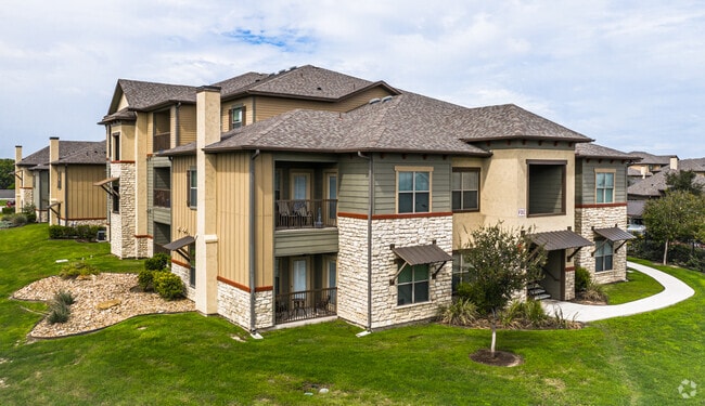
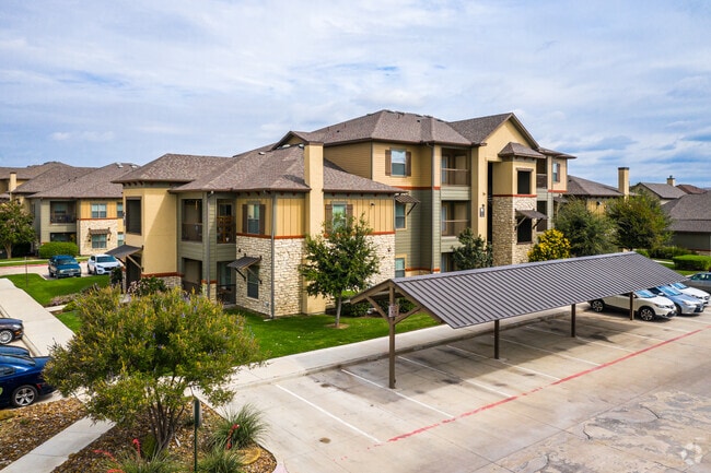
7902 E Country Dr
Laredo, TX
EAST COUNTRY, BLOCK 1, LOT 2, PHASE I, UNINHABITABLE
530050
Webb
Multifamilydwelling
Texas
A Areas with a 1% annual chance of flooding and a 26% chance of flooding over the life of a 30-year mortgage.
2
2024
11.84 AC
2025
Texas South Area
001723
Other Market Areas
254,594 SF
NEARBY LISTINGS FOR SALE OR LEASE
-
-
View all Laredo listings for sale on LoopNet.com
DEMOGRAPHICS near 7902 E Country Dr
1 mile
3 mile
5 mile
2025 Total Population
9,090
58,715
122,014
2030 Population
9,419
60,235
124,753
Pop Growth 2025-2030
+ 3.62%
+ 2.59%
+ 2.24%
Average Age
35
35
36
2025 Total Households
2,775
18,264
38,220
HH Growth 2025-2030
+ 3.82%
+ 2.82%
+ 2.45%
Median Household Inc
$106,098
$90,368
$72,659
Avg Household Size
3.20
3.20
3.10
2025 Avg HH Vehicles
2.00
2.00
2.00
Median Home Value
$362,119
$297,575
$247,243
Median Year Built
2009
2004
1997
Nearby Places
Map Layers
Map Styles
 Street
 Aerial
Transit
 Traffic
 Biking
Places
Listings with unknown addresses are not visible on the map
- Restaurants
- Banks
- Shops
- Fitness
- Groceries
PUBLIC TRANSPORTATION
AIRPORT
Laredo International
Drive
Walk
Distance
Laredo International
7 min
4.1 mi
Freight Ports
Port of Corpus Christi
Drive
Walk
Distance
Port of Corpus Christi
162 min
143.0 mi
Nearby Properties
Address
Land Use
TOTAL SIZE
Lot Size
Zoning
Address
Land Use
TOTAL SIZE
Lot Size
Zoning
1,443,608 SF
116.27 AC
Address
Land Use
TOTAL SIZE
Lot Size
Zoning
430,587 SF
30 AC
R1
Address
Land Use
TOTAL SIZE
Lot Size
Zoning
178,000 SF
23.50 AC
B4
Address
Land Use
TOTAL SIZE
Lot Size
Zoning
251,512 SF
57.32 AC
B4
Address
Land Use
TOTAL SIZE
Lot Size
Zoning
337,607 SF
45.06 AC
R1
Address
Land Use
TOTAL SIZE
Lot Size
Zoning
255,819 SF
50 AC
R1
Address
Land Use
TOTAL SIZE
Lot Size
Zoning
649,220 SF
38.29 AC
M1
Address
Land Use
TOTAL SIZE
Lot Size
Zoning
164,276 SF
43.92 AC
Address
Land Use
TOTAL SIZE
Lot Size
Zoning
109,695 SF
3.73 AC
M1
Address
Land Use
TOTAL SIZE
Lot Size
Zoning
194,520 SF
11.18 AC
B3
Address
Land Use
TOTAL SIZE
Lot Size
Zoning
192,203 SF
22.01 AC
B4
Address
Land Use
TOTAL SIZE
Lot Size
Zoning
136,981 SF
10.01 AC
Address
Land Use
TOTAL SIZE
Lot Size
Zoning
203,922 SF
11 AC
R2
Address
Land Use
TOTAL SIZE
Lot Size
Zoning
170,632 SF
8.03 AC
B3
Address
Land Use
TOTAL SIZE
Lot Size
Zoning
158,728 SF
7.89 AC
Address
Land Use
TOTAL SIZE
Lot Size
Zoning
101,034 SF
19.79 AC
Address
Land Use
TOTAL SIZE
Lot Size
Zoning
50,765 SF
39.73 AC
Address
Land Use
TOTAL SIZE
Lot Size
Zoning
100,598 SF
26.22 AC
Address
Land Use
TOTAL SIZE
Lot Size
Zoning
95,769 SF
11.81 AC
Address
Land Use
TOTAL SIZE
Lot Size
Zoning
176,926 SF
8.70 AC
R2
Address
Land Use
TOTAL SIZE
Lot Size
Zoning
172,485 SF
9.24 AC
R2
Address
Land Use
TOTAL SIZE
Lot Size
Zoning
93,707 SF
12.29 AC
Address
Land Use
TOTAL SIZE
Lot Size
Zoning
95,769 SF
10 AC
AG
Address
Land Use
TOTAL SIZE
Lot Size
Zoning
120,103 SF
12.36 AC
B4
Address
Land Use
TOTAL SIZE
Lot Size
Zoning
95,769 SF
8.30 AC
R1
Address
Land Use
TOTAL SIZE
Lot Size
Zoning
70,453 SF
21.12 AC
AG
Address
Land Use
TOTAL SIZE
Lot Size
Zoning
92,700 SF
8.49 AC
R1
Address
Land Use
TOTAL SIZE
Lot Size
Zoning
121,400 SF
12.92 AC
B4
Address
Land Use
TOTAL SIZE
Lot Size
Zoning
139,605 SF
6.98 AC
The World's #1 Commercial Real Estate Marketplace
Connect with us
© 2026 CoStar Group
The information above has been obtained from sources believed reliable. While we do not doubt its accuracy we have not verified it and make no guarantee, warranty or representation about it. It is your responsibility to independently confirm its accuracy and completeness. Any projections, opinions, assumptions, or estimates used are for example only and do not represent the current or future performance of the property. The value of this transaction to you depends on tax and other factors which should be evaluated by your tax, financial, and legal advisors. You and your advisors should conduct a careful, independent investigation of the property to determine to your satisfaction the suitability of the property for your needs.