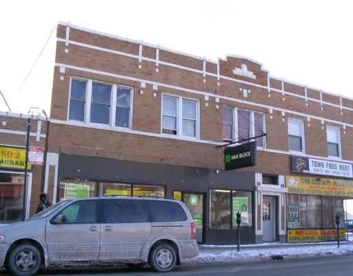
Property Record
431 E 79Th St S, Chicago, IL 60619


NEARBY LISTINGS FOR SALE OR LEASE
Property Detail
431 E 79Th St S
Chicago-Naperville-Elgin, IL-IN-WI
Chatham Fields
20-34-201-001-0000
(CHATHAM)(FIELDS) SUB OF PT NE SEC 34-38-14
Apartment
Cook
X
Illinois
17031C0538K
10,9
2023
0.16 AC
2025
South Chicago
440101
Chicago
13,205 SF
DEMOGRAPHICS near 431 E 79Th St S
1 Mile
3 Mile
5 Mile
2024 Total Population
37,085
283,257
594,986
2029 Population
35,672
274,472
573,683
Pop Growth 2024-2029
(3.81%)
(3.10%)
(3.58%)
Average Age
42
40
39
2024 Total Households
17,055
118,631
239,211
HH Growth 2024-2029
(4.25%)
(3.46%)
(3.77%)
Median Household Inc
$34,376
$36,767
$40,929
Avg Household Size
2.10
2.30
2.40
2024 Avg HH Vehicles
1.00
1.00
1.00
Median Home Value
$196,715
$174,477
$184,428
Median Year Built
1947
1948
1948
Nearby Places
Map Layers
Map Styles
 Street
 Aerial
- Restaurants
- Banks
- Shops
- Fitness
- Groceries
PUBLIC TRANSPORTATION
TRANSIT/SUBWAY
79th Street Station (Red Line - Chicago Transit Authority "L" Trains (The "L"))
DRIVE
WALK
Distance
79th Street Station (Red Line - Chicago Transit Authority "L" Trains (The "L"))
5 min
12 min
0.6 mi
79th Street Station (Metra Electric Line - Northeast Illinois Regional Commuter Railroad (Metra))
DRIVE
WALK
Distance
79th Street Station (Metra Electric Line - Northeast Illinois Regional Commuter Railroad (Metra))
3 min
17 min
0.9 mi
COMMUTER RAIL
Gresham Station (Rock Island District Line - Northeast Illinois Regional Commuter Railroad (Metra))
DRIVE
WALK
Distance
Gresham Station (Rock Island District Line - Northeast Illinois Regional Commuter Railroad (Metra))
9 min
2.7 mi
Brainerd Station (Rock Island District Line - Northeast Illinois Regional Commuter Railroad (Metra))
DRIVE
WALK
Distance
Brainerd Station (Rock Island District Line - Northeast Illinois Regional Commuter Railroad (Metra))
12 min
3.2 mi
AIRPORT
Chicago Midway International
DRIVE
WALK
Distance
Chicago Midway International
26 min
15.7 mi
Chicago O'Hare International
DRIVE
WALK
Distance
Chicago O'Hare International
36 min
27.2 mi
SALE & LEASE HISTORY
LISTING DATE
SALE/LEASE

Sep 29, 2017
For Sale
Nearby Properties
Address
Land Use
TOTAL SIZE
Lot Size
Zoning
Address
Land Use
TOTAL SIZE
Lot Size
Zoning
0.49 AC
SLI
Address
Land Use
TOTAL SIZE
Lot Size
Zoning
10.73 AC
PD 1243
Address
Land Use
TOTAL SIZE
Lot Size
Zoning
109,145 SF
0.46 AC
RM-5
Address
Land Use
TOTAL SIZE
Lot Size
Zoning
159,300 SF
13.36 AC
PD 425
Address
Land Use
TOTAL SIZE
Lot Size
Zoning
115,000 SF
1.97 AC
C1-2
Address
Land Use
TOTAL SIZE
Lot Size
Zoning
Address
Land Use
TOTAL SIZE
Lot Size
Zoning
0.91 AC
PD 1177
Address
Land Use
TOTAL SIZE
Lot Size
Zoning
62,216 SF
0.65 AC
RM-5
Address
Land Use
TOTAL SIZE
Lot Size
Zoning
115,000 SF
1.12 AC
C1-2
Address
Land Use
TOTAL SIZE
Lot Size
Zoning
7,200 SF
0.22 AC
B3-3
Address
Land Use
TOTAL SIZE
Lot Size
Zoning
PD 43
Address
Land Use
TOTAL SIZE
Lot Size
Zoning
Address
Land Use
TOTAL SIZE
Lot Size
Zoning
PD 43
Address
Land Use
TOTAL SIZE
Lot Size
Zoning
78,000 SF
0.62 AC
RM-5
Address
Land Use
TOTAL SIZE
Lot Size
Zoning
36,365 SF
Address
Land Use
TOTAL SIZE
Lot Size
Zoning
23,799 SF
0.91 AC
PD 571
Address
Land Use
TOTAL SIZE
Lot Size
Zoning
7.47 AC
RT-4
Address
Land Use
TOTAL SIZE
Lot Size
Zoning
0.84 AC
RM-5
Address
Land Use
TOTAL SIZE
Lot Size
Zoning
13,700 SF
0.33 AC
B3-2
Address
Land Use
TOTAL SIZE
Lot Size
Zoning
141,165 SF
7.82 AC
PD 966
Address
Land Use
TOTAL SIZE
Lot Size
Zoning
0.18 AC
PD 43
Address
Land Use
TOTAL SIZE
Lot Size
Zoning
15,052 SF
1.03 AC
PQ
Address
Land Use
TOTAL SIZE
Lot Size
Zoning
Address
Land Use
TOTAL SIZE
Lot Size
Zoning
65,186 SF
10.47 AC
PD 566
Address
Land Use
TOTAL SIZE
Lot Size
Zoning
101,294 SF
8.10 AC
B3-1
Address
Land Use
TOTAL SIZE
Lot Size
Zoning
145,291 SF
7.85 AC
B3-2
Address
Land Use
TOTAL SIZE
Lot Size
Zoning
184,487 SF
0.66 AC
RM-5,RS-3
Address
Land Use
TOTAL SIZE
Lot Size
Zoning
111,198 SF
10.60 AC
PD 566
Address
Land Use
TOTAL SIZE
Lot Size
Zoning
743,663 SF
7.14 AC
RT-4
Address
Land Use
TOTAL SIZE
Lot Size
Zoning
15,600 SF
0.18 AC
C2-1
The World's #1 Commercial Real Estate Marketplace
Connect with us
© 2026 CoStar Group
The information above has been obtained from sources believed reliable. While we do not doubt its accuracy we have not verified it and make no guarantee, warranty or representation about it. It is your responsibility to independently confirm its accuracy and completeness. Any projections, opinions, assumptions, or estimates used are for example only and do not represent the current or future performance of the property. The value of this transaction to you depends on tax and other factors which should be evaluated by your tax, financial, and legal advisors. You and your advisors should conduct a careful, independent investigation of the property to determine to your satisfaction the suitability of the property for your needs.