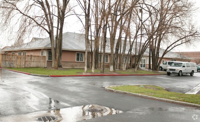
Property Record
7908 S Old Bingham Hwy, West Jordan, UT 84088
NEARBY LISTINGS FOR SALE OR LEASE
Property Detail
7908 S Old Bingham Hwy
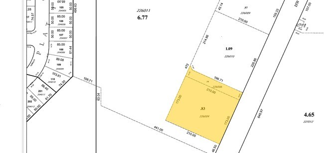
21-32-226-004-0000
BEG S 89^5709 W 807.88 FT & S 620.92 FT FR NE COR SEC 32, T 2S, R 1W, SLM; N 66^0451 W 210 FT; N 23^5509 E 41 FT; S 24^ E 17.91 FT; S 66^0451 E 196.71 FT; S 23^5509 W 29 FT TO BEG. 0.14 AC M OR L. 6357-1348,1351 7094-1784 08334-0001
Daycare
Salt Lake
X
Utah
49035C0430G
0.83 AC
2024
Southwest Valley
2025
Salt Lake City
112916
Salt Lake City, UT
10,021 SF
DEMOGRAPHICS near 7908 S Old Bingham Hwy
1 Mile
3 Mile
5 Mile
2024 Total Population
15,131
135,210
356,983
2029 Population
15,174
136,891
362,957
Pop Growth 2024-2029
+ 0.28%
+ 1.24%
+ 1.67%
Average Age
36
37
36
2024 Total Households
4,607
41,690
111,498
HH Growth 2024-2029
+ 0.20%
+ 1.17%
+ 1.62%
Median Household Inc
$90,430
$90,105
$87,117
Avg Household Size
3.20
3.20
3.10
2024 Avg HH Vehicles
2.00
2.00
2.00
Median Home Value
$394,065
$410,817
$415,521
Median Year Built
1986
1992
1993
Nearby Places
Map Layers
Map Styles
 Street
 Aerial
- Restaurants
- Banks
- Shops
- Fitness
- Groceries
PUBLIC TRANSPORTATION
COMMUTER RAIL
DRIVE
WALK
Distance
14 min
6.8 mi
AIRPORT
Salt Lake City International
DRIVE
WALK
Distance
Salt Lake City International
21 min
12.8 mi
Provo Municipal
DRIVE
WALK
Distance
Provo Municipal
53 min
38.4 mi
Nearby Properties
Address
Land Use
TOTAL SIZE
Lot Size
Zoning
Address
Land Use
TOTAL SIZE
Lot Size
Zoning
733,215 SF
58.65 AC
M-1
Address
Land Use
TOTAL SIZE
Lot Size
Zoning
338,177 SF
21.91 AC
M-1
Address
Land Use
TOTAL SIZE
Lot Size
Zoning
895,175 SF
28.95 AC
SSD-X
Address
Land Use
TOTAL SIZE
Lot Size
Zoning
233,853 SF
6.05 AC
HFR
Address
Land Use
TOTAL SIZE
Lot Size
Zoning
198,801 SF
8.36 AC
R-3-20
Address
Land Use
TOTAL SIZE
Lot Size
Zoning
308,722 SF
21.29 AC
M-1
Address
Land Use
TOTAL SIZE
Lot Size
Zoning
427,884 SF
18.22 AC
JB-4
Address
Land Use
TOTAL SIZE
Lot Size
Zoning
187.81 AC
P-F
Address
Land Use
TOTAL SIZE
Lot Size
Zoning
362,000 SF
51.81 AC
P-F
Address
Land Use
TOTAL SIZE
Lot Size
Zoning
497,522 SF
16.43 AC
MH
Address
Land Use
TOTAL SIZE
Lot Size
Zoning
679,800 SF
18.14 AC
BJ-1-3
Address
Land Use
TOTAL SIZE
Lot Size
Zoning
308,722 SF
20.45 AC
M-1
Address
Land Use
TOTAL SIZE
Lot Size
Zoning
448,232 SF
9.08 AC
PC
Address
Land Use
TOTAL SIZE
Lot Size
Zoning
74,120 SF
12.61 AC
BJ
Address
Land Use
TOTAL SIZE
Lot Size
Zoning
256,167 SF
13.56 AC
P-C
Address
Land Use
TOTAL SIZE
Lot Size
Zoning
321,397 SF
11.16 AC
BJ
Address
Land Use
TOTAL SIZE
Lot Size
Zoning
410,435 SF
2.43 AC
P-C
Address
Land Use
TOTAL SIZE
Lot Size
Zoning
77,525 SF
2.35 AC
P-C
Address
Land Use
TOTAL SIZE
Lot Size
Zoning
45,924 SF
18.15 AC
R-3-20
Address
Land Use
TOTAL SIZE
Lot Size
Zoning
114.79 AC
PF
Address
Land Use
TOTAL SIZE
Lot Size
Zoning
143,314 SF
2.30 AC
P-C
Address
Land Use
TOTAL SIZE
Lot Size
Zoning
289,838 SF
24.11 AC
BJ-3
Address
Land Use
TOTAL SIZE
Lot Size
Zoning
117,521 SF
57.92 AC
PF
Address
Land Use
TOTAL SIZE
Lot Size
Zoning
28,515 SF
6.77 AC
PC
Address
Land Use
TOTAL SIZE
Lot Size
Zoning
40,042 SF
15.43 AC
R-3-16
Address
Land Use
TOTAL SIZE
Lot Size
Zoning
203,064 SF
5.91 AC
PC
Address
Land Use
TOTAL SIZE
Lot Size
Zoning
120,929 SF
7.23 AC
PC
Address
Land Use
TOTAL SIZE
Lot Size
Zoning
76,837 SF
50.54 AC
P-F
Address
Land Use
TOTAL SIZE
Lot Size
Zoning
268,200 SF
44.38 AC
PF
Address
Land Use
TOTAL SIZE
Lot Size
Zoning
36,708 SF
12.83 AC
R-3-16
The World's #1 Commercial Real Estate Marketplace
Connect with us
© 2025 CoStar Group
The information above has been obtained from sources believed reliable. While we do not doubt its accuracy we have not verified it and make no guarantee, warranty or representation about it. It is your responsibility to independently confirm its accuracy and completeness. Any projections, opinions, assumptions, or estimates used are for example only and do not represent the current or future performance of the property. The value of this transaction to you depends on tax and other factors which should be evaluated by your tax, financial, and legal advisors. You and your advisors should conduct a careful, independent investigation of the property to determine to your satisfaction the suitability of the property for your needs.