Property Record
7909 Edmund Hwy, Pelion, SC 29123

NEARBY LISTINGS FOR SALE OR LEASE
Property Detail
7909 Edmund Hwy
011700-02-026
BRANDI COMMERICAL SUB PARCEL 3-A
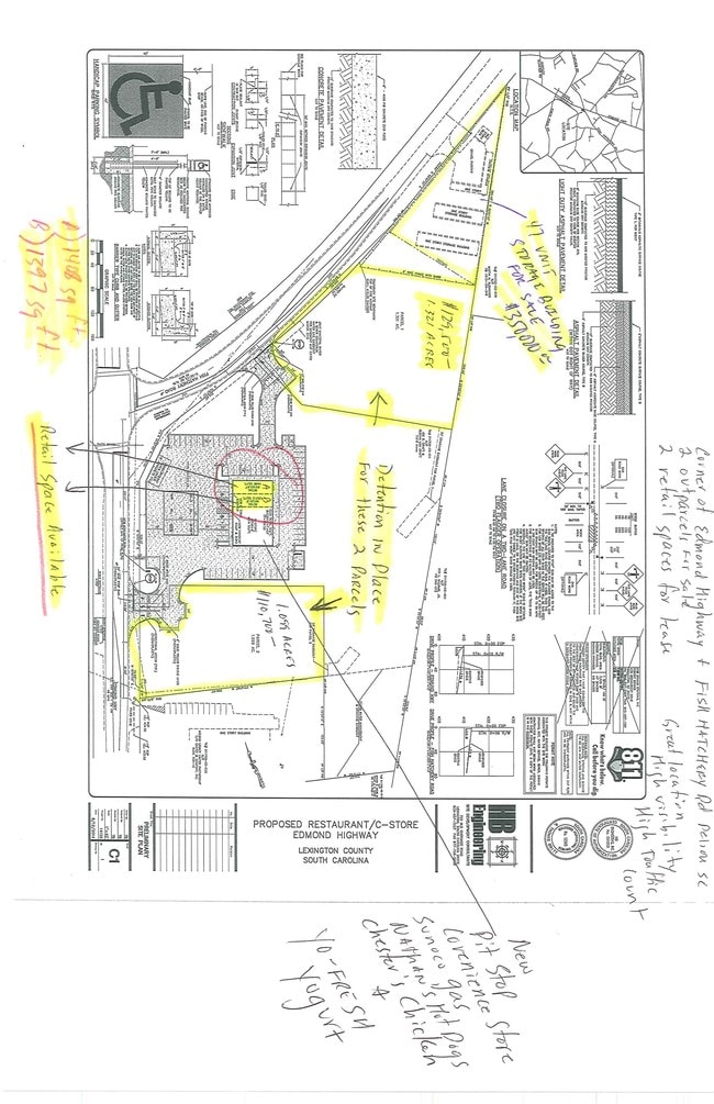
Conveniencestore
Lexington
X
South Carolina
45063C0390J
4.31 AC
2025
Outlying Lexington County
2024
Columbia
020910
Columbia, SC
7,128 SF
DEMOGRAPHICS near 7909 Edmund Hwy
1 Mile
3 Mile
5 Mile
2024 Total Population
624
4,597
12,672
2029 Population
684
5,066
13,968
Pop Growth 2024-2029
+ 9.62%
+ 10.20%
+ 10.23%
Average Age
40
40
39
2024 Total Households
242
1,739
4,765
HH Growth 2024-2029
+ 9.92%
+ 10.35%
+ 10.39%
Median Household Inc
$54,230
$50,120
$49,173
Avg Household Size
2.50
2.50
2.60
2024 Avg HH Vehicles
2.00
2.00
2.00
Median Home Value
$95,959
$109,633
$113,249
Median Year Built
1989
1992
1993
Nearby Places
Map Layers
Map Styles
 Street
 Aerial
- Restaurants
- Banks
- Shops
- Fitness
- Groceries
PUBLIC TRANSPORTATION
AIRPORT
Columbia Metro
DRIVE
WALK
Distance
Columbia Metro
28 min
14.2 mi
SALE & LEASE HISTORY
LISTING DATE
SALE/LEASE

Jan 12, 2017
For Lease
Nearby Properties
Address
Land Use
TOTAL SIZE
Lot Size
Zoning
Address
Land Use
TOTAL SIZE
Lot Size
Zoning
10,650 SF
2.80 AC
LR
Address
Land Use
TOTAL SIZE
Lot Size
Zoning
6,250 SF
10.15 AC
LR
Address
Land Use
TOTAL SIZE
Lot Size
Zoning
34,860 SF
44.88 AC
RD
Address
Land Use
TOTAL SIZE
Lot Size
Zoning
27,840 SF
3.74 AC
LR
Address
Land Use
TOTAL SIZE
Lot Size
Zoning
54.75 AC
Address
Land Use
TOTAL SIZE
Lot Size
Zoning
5,076 SF
6.05 AC
LR
Address
Land Use
TOTAL SIZE
Lot Size
Zoning
9,191 SF
1.50 AC
LR
Address
Land Use
TOTAL SIZE
Lot Size
Zoning
988 SF
87 AC
LR
Address
Land Use
TOTAL SIZE
Lot Size
Zoning
3,750 SF
1.41 AC
RL
Address
Land Use
TOTAL SIZE
Lot Size
Zoning
70.79 AC
RD
Address
Land Use
TOTAL SIZE
Lot Size
Zoning
9,000 SF
1.16 AC
Address
Land Use
TOTAL SIZE
Lot Size
Zoning
3,660 SF
2.04 AC
C
Address
Land Use
TOTAL SIZE
Lot Size
Zoning
147.66 AC
LR
Address
Land Use
TOTAL SIZE
Lot Size
Zoning
3,222 SF
21.75 AC
LR
Address
Land Use
TOTAL SIZE
Lot Size
Zoning
1,200 SF
0.90 AC
ID
Address
Land Use
TOTAL SIZE
Lot Size
Zoning
129.57 AC
LR
Address
Land Use
TOTAL SIZE
Lot Size
Zoning
3,550 SF
0.57 AC
LR
Address
Land Use
TOTAL SIZE
Lot Size
Zoning
4,648 SF
2 AC
A
Address
Land Use
TOTAL SIZE
Lot Size
Zoning
114.42 AC
RD
Address
Land Use
TOTAL SIZE
Lot Size
Zoning
91.91 AC
Address
Land Use
TOTAL SIZE
Lot Size
Zoning
4,500 SF
1.02 AC
ID
Address
Land Use
TOTAL SIZE
Lot Size
Zoning
2,033 SF
0.29 AC
LR
Address
Land Use
TOTAL SIZE
Lot Size
Zoning
4,000 SF
20 AC
LR
Address
Land Use
TOTAL SIZE
Lot Size
Zoning
85.71 AC
Address
Land Use
TOTAL SIZE
Lot Size
Zoning
4,058 SF
2.63 AC
Address
Land Use
TOTAL SIZE
Lot Size
Zoning
2,730 SF
2.55 AC
C
Address
Land Use
TOTAL SIZE
Lot Size
Zoning
16,212 SF
2.07 AC
ID
Address
Land Use
TOTAL SIZE
Lot Size
Zoning
1,762 SF
2.16 AC
LR
Address
Land Use
TOTAL SIZE
Lot Size
Zoning
2,460 SF
0.60 AC
LR
The World's #1 Commercial Real Estate Marketplace
Connect with us
© 2026 CoStar Group
The information above has been obtained from sources believed reliable. While we do not doubt its accuracy we have not verified it and make no guarantee, warranty or representation about it. It is your responsibility to independently confirm its accuracy and completeness. Any projections, opinions, assumptions, or estimates used are for example only and do not represent the current or future performance of the property. The value of this transaction to you depends on tax and other factors which should be evaluated by your tax, financial, and legal advisors. You and your advisors should conduct a careful, independent investigation of the property to determine to your satisfaction the suitability of the property for your needs.