Property Record
7910 Ne Day Rd W, Bainbridge Island, WA 98110
NEARBY LISTINGS FOR SALE OR LEASE
-
-
View all Bainbridge Island listings for lease on LoopNet.com
Property Detail
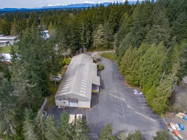
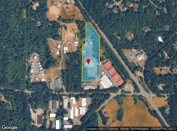
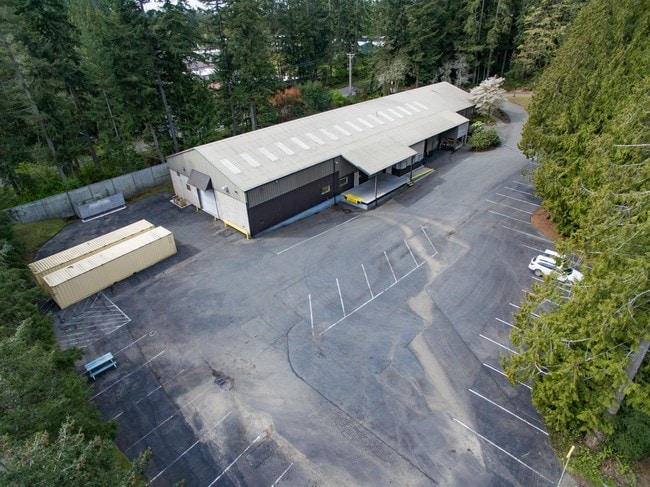
7910 Ne Day Rd W
042502-4-038-2009
RESULTANT PARCEL F OF BOUNDARY LINE ADJUSTMENT RECORDED UNDER AUDITORS FILE NO. 201407250037, AND AS DEPICTED ON SURVEY RECORDED UNDER AUDITORS FILE NO. 201407250036, IN VOLUME 79 OF SURVEYS, PAGES 153 - 154, RECORDS OF KITSAP COUNTY, WASHINGTON, BEI
Warehouse
Kitsap
X
Washington
53035C0245F
a
2025
6.52 AC
2026
Bainbridge Island
090800
Bremerton/Silverdale
21,400 SF
Bremerton-Silverdale, WA
DEMOGRAPHICS near 7910 Ne Day Rd W
1 Mile
3 Mile
5 Mile
2024 Total Population
1,581
11,295
37,201
2029 Population
1,586
11,330
37,286
Pop Growth 2024-2029
+ 0.32%
+ 0.31%
+ 0.23%
Average Age
46
47
46
2024 Total Households
605
4,401
14,861
HH Growth 2024-2029
+ 0.50%
+ 0.34%
+ 0.26%
Median Household Inc
$179,807
$173,956
$127,042
Avg Household Size
2.60
2.50
2.40
2024 Avg HH Vehicles
2.00
2.00
2.00
Median Home Value
$896,915
$930,459
$767,129
Median Year Built
1979
1983
1986
Nearby Places
Map Layers
Map Styles
 Street
 Aerial
- Restaurants
- Banks
- Shops
- Fitness
- Groceries
PUBLIC TRANSPORTATION
AIRPORT
Seattle Paine Field International
DRIVE
WALK
Distance
Seattle Paine Field International
73 min
29.1 mi
Seattle-Tacoma International
DRIVE
WALK
Distance
Seattle-Tacoma International
97 min
49.0 mi
Freight Ports
Port of Seattle
DRIVE
WALK
Distance
Port of Seattle
85 min
39.5 mi
SALE & LEASE HISTORY
LISTING DATE
SALE/LEASE

May 12, 2017
For Sale
Mar 31, 2017
For Lease
Aug 25, 2024
For Lease
Nearby Properties
Address
Land Use
TOTAL SIZE
Lot Size
Zoning
Address
Land Use
TOTAL SIZE
Lot Size
Zoning
7.01 AC
CITY
Address
Land Use
TOTAL SIZE
Lot Size
Zoning
74,440 SF
4.36 AC
B/I
Address
Land Use
TOTAL SIZE
Lot Size
Zoning
73,500 SF
4.84 AC
R-2
Address
Land Use
TOTAL SIZE
Lot Size
Zoning
46,266 SF
2.22 AC
R-8
Address
Land Use
TOTAL SIZE
Lot Size
Zoning
29,280 SF
5 AC
B/I
Address
Land Use
TOTAL SIZE
Lot Size
Zoning
25,695 SF
2.02 AC
B/I
Address
Land Use
TOTAL SIZE
Lot Size
Zoning
17,960 SF
0.51 AC
B/I
Address
Land Use
TOTAL SIZE
Lot Size
Zoning
1,782 SF
47.41 AC
R-2
Address
Land Use
TOTAL SIZE
Lot Size
Zoning
17,548 SF
2.95 AC
R-8
Address
Land Use
TOTAL SIZE
Lot Size
Zoning
16,255 SF
1.25 AC
B/I
Address
Land Use
TOTAL SIZE
Lot Size
Zoning
2,720 SF
4.55 AC
B/I
Address
Land Use
TOTAL SIZE
Lot Size
Zoning
22,007 SF
1.15 AC
NC
Address
Land Use
TOTAL SIZE
Lot Size
Zoning
52,528 SF
5.61 AC
R-0.4
Address
Land Use
TOTAL SIZE
Lot Size
Zoning
13,504 SF
0.27 AC
B/I
Address
Land Use
TOTAL SIZE
Lot Size
Zoning
9,177 SF
2 AC
B/I
Address
Land Use
TOTAL SIZE
Lot Size
Zoning
14,663 SF
4.63 AC
R-2
Address
Land Use
TOTAL SIZE
Lot Size
Zoning
9,177 SF
0.86 AC
B/I
Address
Land Use
TOTAL SIZE
Lot Size
Zoning
19,954 SF
5 AC
B/I
Address
Land Use
TOTAL SIZE
Lot Size
Zoning
29,760 SF
2.95 AC
B/I
Address
Land Use
TOTAL SIZE
Lot Size
Zoning
6,669 SF
5.56 AC
R-2
Address
Land Use
TOTAL SIZE
Lot Size
Zoning
12,544 SF
1.19 AC
B/I
Address
Land Use
TOTAL SIZE
Lot Size
Zoning
17,600 SF
2.79 AC
NC
Address
Land Use
TOTAL SIZE
Lot Size
Zoning
8,585 SF
14.25 AC
F1
Address
Land Use
TOTAL SIZE
Lot Size
Zoning
13,504 SF
4.57 AC
R-0.4
Address
Land Use
TOTAL SIZE
Lot Size
Zoning
11,296 SF
3.64 AC
R-2.9
Address
Land Use
TOTAL SIZE
Lot Size
Zoning
15,727 SF
2.41 AC
R-2
Address
Land Use
TOTAL SIZE
Lot Size
Zoning
8,880 SF
0.96 AC
B/I
Address
Land Use
TOTAL SIZE
Lot Size
Zoning
3,968 SF
2.53 AC
B/I
Address
Land Use
TOTAL SIZE
Lot Size
Zoning
2,016 SF
3.88 AC
R-2
The World's #1 Commercial Real Estate Marketplace
Connect with us
© 2025 CoStar Group
The information above has been obtained from sources believed reliable. While we do not doubt its accuracy we have not verified it and make no guarantee, warranty or representation about it. It is your responsibility to independently confirm its accuracy and completeness. Any projections, opinions, assumptions, or estimates used are for example only and do not represent the current or future performance of the property. The value of this transaction to you depends on tax and other factors which should be evaluated by your tax, financial, and legal advisors. You and your advisors should conduct a careful, independent investigation of the property to determine to your satisfaction the suitability of the property for your needs.