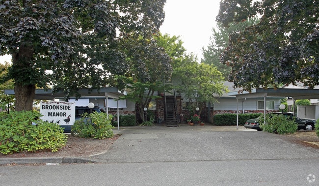
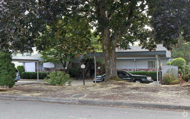
Property Record
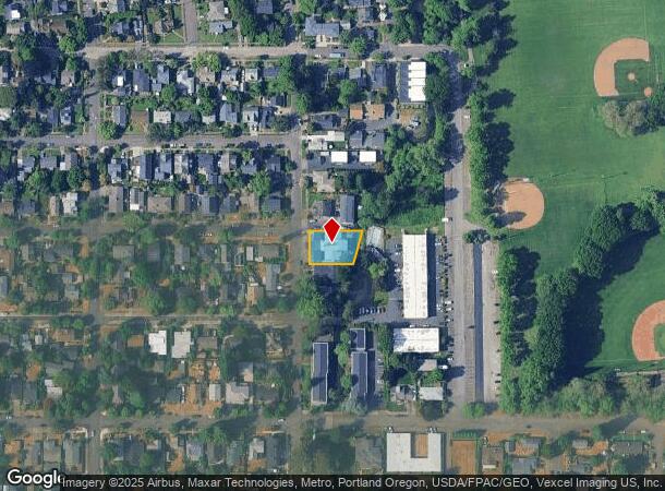
7910 Se 21St Ave, Portland, OR 97202

NEARBY LISTINGS FOR SALE OR LEASE
Property Detail
7910 Se 21St Ave
Portland-Vancouver-Hillsboro, OR-WA
Moseley Add
R221203
MOSELEY ADD, BLOCK 8, LOT 1
Quadruplex
Multnomah
ARE
Oregon
41067C0575E
1
2025
0.23 AC
2025
Sellwood-Moreland
000201
Portland
3,621 SF
DEMOGRAPHICS near 7910 Se 21St Ave
1 Mile
3 Mile
5 Mile
2024 Total Population
17,667
138,528
426,838
2029 Population
17,458
137,298
424,488
Pop Growth 2024-2029
(1.18%)
(0.89%)
(0.55%)
Average Age
42
41
41
2024 Total Households
7,695
59,766
194,384
HH Growth 2024-2029
(1.48%)
(1.04%)
(0.63%)
Median Household Inc
$98,860
$91,103
$84,514
Avg Household Size
2.20
2.20
2.10
2024 Avg HH Vehicles
2.00
2.00
1.00
Median Home Value
$706,124
$561,177
$598,275
Median Year Built
1950
1961
1970
Nearby Places
Map Layers
Map Styles
 Street
 Aerial
- Restaurants
- Banks
- Shops
- Fitness
- Groceries
PUBLIC TRANSPORTATION
COMMUTER RAIL
DRIVE
WALK
Distance
15 min
6.0 mi
DRIVE
WALK
Distance
18 min
8.5 mi
AIRPORT
Portland International
DRIVE
WALK
Distance
Portland International
29 min
15.4 mi
Freight Ports
Port of Portland
DRIVE
WALK
Distance
Port of Portland
18 min
8.6 mi
Nearby Properties
Address
Land Use
TOTAL SIZE
Lot Size
Zoning
Address
Land Use
TOTAL SIZE
Lot Size
Zoning
931,749 SF
85.50 AC
CI1
Address
Land Use
TOTAL SIZE
Lot Size
Zoning
822,867 SF
103.39 AC
CI1
Address
Land Use
TOTAL SIZE
Lot Size
Zoning
1.09 AC
EX
Address
Land Use
TOTAL SIZE
Lot Size
Zoning
2.24 AC
CX
Address
Land Use
TOTAL SIZE
Lot Size
Zoning
251,293 SF
14.15 AC
IR
Address
Land Use
TOTAL SIZE
Lot Size
Zoning
138,295 SF
29.79 AC
CI1
Address
Land Use
TOTAL SIZE
Lot Size
Zoning
473,746 SF
1.68 AC
Address
Land Use
TOTAL SIZE
Lot Size
Zoning
Address
Land Use
TOTAL SIZE
Lot Size
Zoning
147,334 SF
10.92 AC
IG1
Address
Land Use
TOTAL SIZE
Lot Size
Zoning
198,107 SF
4.03 AC
R2.5
Address
Land Use
TOTAL SIZE
Lot Size
Zoning
453,461 SF
1.16 AC
CX
Address
Land Use
TOTAL SIZE
Lot Size
Zoning
44,644 SF
2.18 AC
R2
Address
Land Use
TOTAL SIZE
Lot Size
Zoning
6.48 AC
R-3
Address
Land Use
TOTAL SIZE
Lot Size
Zoning
282,840 SF
1.46 AC
CX
Address
Land Use
TOTAL SIZE
Lot Size
Zoning
404,000 SF
0.92 AC
CXD
Address
Land Use
TOTAL SIZE
Lot Size
Zoning
362,725 SF
16.52 AC
IG1
Address
Land Use
TOTAL SIZE
Lot Size
Zoning
279,607 SF
1.67 AC
CX
Address
Land Use
TOTAL SIZE
Lot Size
Zoning
3,550 SF
3.99 AC
DMU
Address
Land Use
TOTAL SIZE
Lot Size
Zoning
2,108 SF
12.08 AC
HDR
Address
Land Use
TOTAL SIZE
Lot Size
Zoning
198,988 SF
1.02 AC
CXD
Address
Land Use
TOTAL SIZE
Lot Size
Zoning
222,120 SF
6.87 AC
RM2
Address
Land Use
TOTAL SIZE
Lot Size
Zoning
57,300 SF
4.38 AC
R5
Address
Land Use
TOTAL SIZE
Lot Size
Zoning
220,655 SF
1.16 AC
CXDG
Address
Land Use
TOTAL SIZE
Lot Size
Zoning
137,908 SF
1.83 AC
R2.5
Address
Land Use
TOTAL SIZE
Lot Size
Zoning
0.26 AC
C3
Address
Land Use
TOTAL SIZE
Lot Size
Zoning
2.12 AC
OS
Address
Land Use
TOTAL SIZE
Lot Size
Zoning
184,285 SF
0.91 AC
CX
Address
Land Use
TOTAL SIZE
Lot Size
Zoning
176,428 SF
1.31 AC
CM2
Address
Land Use
TOTAL SIZE
Lot Size
Zoning
62,048 SF
8.58 AC
R20
Address
Land Use
TOTAL SIZE
Lot Size
Zoning
143,116 SF
0.92 AC
CM2
The World's #1 Commercial Real Estate Marketplace
Connect with us
© 2026 CoStar Group
The information above has been obtained from sources believed reliable. While we do not doubt its accuracy we have not verified it and make no guarantee, warranty or representation about it. It is your responsibility to independently confirm its accuracy and completeness. Any projections, opinions, assumptions, or estimates used are for example only and do not represent the current or future performance of the property. The value of this transaction to you depends on tax and other factors which should be evaluated by your tax, financial, and legal advisors. You and your advisors should conduct a careful, independent investigation of the property to determine to your satisfaction the suitability of the property for your needs.