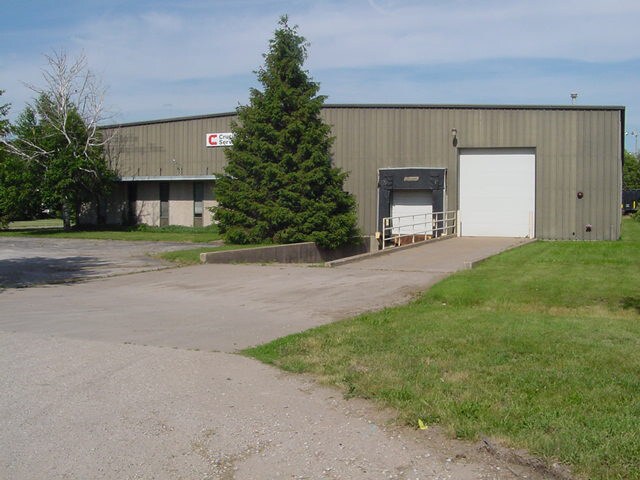
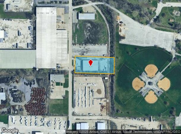
Property Record
7911 29Th St W, Rock Island, IL 61201
NEARBY LISTINGS FOR SALE OR LEASE
Property Detail
7911 29Th St W
Davenport-Moline-Rock Island, IA-IL
Turkey Hollow
16-28-205-004
LOT 3 TURKEY HOLLOW INDUSTRIAL PARK 3RD ADD
Industrialgeneral
Rock Island
AE
Illinois
19163C0500F
3
2024
1.42 AC
2024
Outlying Rock Island Cnty
024200
Davenport/Moline/Rock Island
15,000 SF
DEMOGRAPHICS near 7911 29Th St W
1 Mile
3 Mile
5 Mile
2024 Total Population
872
12,242
47,861
2029 Population
854
11,953
46,915
Pop Growth 2024-2029
(2.06%)
(2.36%)
(1.98%)
Average Age
45
42
41
2024 Total Households
357
5,500
20,271
HH Growth 2024-2029
(1.96%)
(2.40%)
(2.09%)
Median Household Inc
$62,727
$50,742
$55,465
Avg Household Size
2.30
2.20
2.20
2024 Avg HH Vehicles
2.00
2.00
2.00
Median Home Value
$153,826
$140,190
$121,847
Median Year Built
1984
1965
1955
Nearby Places
Map Layers
Map Styles
 Street
 Aerial
- Restaurants
- Banks
- Shops
- Fitness
- Groceries
PUBLIC TRANSPORTATION
AIRPORT
Quad Cities International
DRIVE
WALK
Distance
Quad Cities International
16 min
7.7 mi
SALE & LEASE HISTORY
LISTING DATE
SALE/LEASE

Apr 18, 2017
For Lease
Nearby Properties
Address
Land Use
TOTAL SIZE
Lot Size
Zoning
Address
Land Use
TOTAL SIZE
Lot Size
Zoning
227,249 SF
38.78 AC
RI
Address
Land Use
TOTAL SIZE
Lot Size
Zoning
45,395 SF
10.19 AC
RI
Address
Land Use
TOTAL SIZE
Lot Size
Zoning
204,268 SF
29.49 AC
RI
Address
Land Use
TOTAL SIZE
Lot Size
Zoning
248,000 SF
54.61 AC
RI
Address
Land Use
TOTAL SIZE
Lot Size
Zoning
171,322 SF
19.89 AC
RI
Address
Land Use
TOTAL SIZE
Lot Size
Zoning
20.35 AC
MIL
Address
Land Use
TOTAL SIZE
Lot Size
Zoning
935,332 SF
41.69 AC
MIL
Address
Land Use
TOTAL SIZE
Lot Size
Zoning
242,500 SF
18.66 AC
RI
Address
Land Use
TOTAL SIZE
Lot Size
Zoning
1,800 SF
10 AC
RI
Address
Land Use
TOTAL SIZE
Lot Size
Zoning
14.01 AC
Address
Land Use
TOTAL SIZE
Lot Size
Zoning
79,785 SF
5.61 AC
MIL
Address
Land Use
TOTAL SIZE
Lot Size
Zoning
231,974 SF
7.64 AC
RI
Address
Land Use
TOTAL SIZE
Lot Size
Zoning
248,417 SF
10.63 AC
RI
Address
Land Use
TOTAL SIZE
Lot Size
Zoning
126,580 SF
10.71 AC
RI
Address
Land Use
TOTAL SIZE
Lot Size
Zoning
110,400 SF
2.35 AC
RI
Address
Land Use
TOTAL SIZE
Lot Size
Zoning
198,300 SF
12.45 AC
RI
Address
Land Use
TOTAL SIZE
Lot Size
Zoning
170,666 SF
4.79 AC
MIL
Address
Land Use
TOTAL SIZE
Lot Size
Zoning
62,229 SF
6.94 AC
MIL
Address
Land Use
TOTAL SIZE
Lot Size
Zoning
81,396 SF
30.77 AC
RI
Address
Land Use
TOTAL SIZE
Lot Size
Zoning
9.76 AC
RI
Address
Land Use
TOTAL SIZE
Lot Size
Zoning
90,528 SF
5.42 AC
MIL
Address
Land Use
TOTAL SIZE
Lot Size
Zoning
70,656 SF
11 AC
RI
Address
Land Use
TOTAL SIZE
Lot Size
Zoning
39,858 SF
9.55 AC
RI
Address
Land Use
TOTAL SIZE
Lot Size
Zoning
12.97 AC
Address
Land Use
TOTAL SIZE
Lot Size
Zoning
120,000 SF
5.42 AC
RI
Address
Land Use
TOTAL SIZE
Lot Size
Zoning
6,656 SF
30.95 AC
MIL
Address
Land Use
TOTAL SIZE
Lot Size
Zoning
111,280 SF
10.59 AC
RI
Address
Land Use
TOTAL SIZE
Lot Size
Zoning
7.62 AC
Address
Land Use
TOTAL SIZE
Lot Size
Zoning
5.56 AC
MIL
Address
Land Use
TOTAL SIZE
Lot Size
Zoning
3.88 AC
MIL
The World's #1 Commercial Real Estate Marketplace
Connect with us
© 2025 CoStar Group
The information above has been obtained from sources believed reliable. While we do not doubt its accuracy we have not verified it and make no guarantee, warranty or representation about it. It is your responsibility to independently confirm its accuracy and completeness. Any projections, opinions, assumptions, or estimates used are for example only and do not represent the current or future performance of the property. The value of this transaction to you depends on tax and other factors which should be evaluated by your tax, financial, and legal advisors. You and your advisors should conduct a careful, independent investigation of the property to determine to your satisfaction the suitability of the property for your needs.