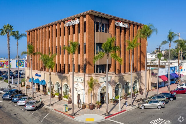
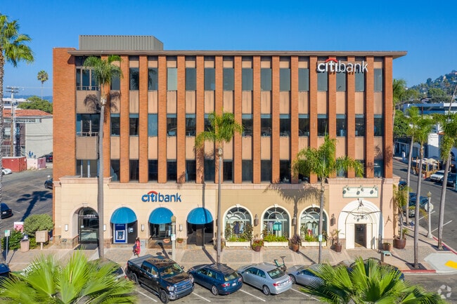
Property Record
1100 Wall St, La Jolla, CA 92037

Current Lease Availabilities
NEARBY LISTINGS FOR SALE OR LEASE
Property Detail
1100 Wall St
San Diego-Carlsbad, CA
La Jolla Park Resub
350-092-19
BLK 53 LOTS 16 & 17 LOTS 14 & 15 & W 69 FT IN TR 000352
Officebuilding
San Diego
X
California
06073C1582H
14-17
2024
0.24 AC
2025
La Jolla
008201
San Diego
41,930 SF
DEMOGRAPHICS near 1100 Wall St
1 Mile
3 Mile
5 Mile
2024 Total Population
8,941
62,496
178,882
2029 Population
9,245
63,018
180,031
Pop Growth 2024-2029
+ 3.40%
+ 0.84%
+ 0.64%
Average Age
53
41
39
2024 Total Households
4,297
23,292
75,264
HH Growth 2024-2029
+ 3.72%
+ 1.14%
+ 0.80%
Median Household Inc
$133,064
$130,286
$104,492
Avg Household Size
1.90
2.20
2.10
2024 Avg HH Vehicles
2.00
2.00
2.00
Median Home Value
$1,133,173
$1,101,674
$1,025,035
Median Year Built
1974
1974
1975
Nearby Places
Map Layers
Map Styles
 Street
 Aerial
- Restaurants
- Banks
- Shops
- Fitness
- Groceries
PUBLIC TRANSPORTATION
COMMUTER RAIL
Sorrento Valley (Coaster - San Diego North County Transit District (Coaster/Sprinter/Breeze))
DRIVE
WALK
Distance
Sorrento Valley (Coaster - San Diego North County Transit District (Coaster/Sprinter/Breeze))
13 min
7.3 mi
Old Town Transit Center (Coaster - San Diego North County Transit District (Coaster/Sprinter/Breeze))
DRIVE
WALK
Distance
Old Town Transit Center (Coaster - San Diego North County Transit District (Coaster/Sprinter/Breeze))
14 min
9.7 mi
AIRPORT
San Diego International
DRIVE
WALK
Distance
San Diego International
17 min
11.3 mi
Freight Ports
Port of San Diego
DRIVE
WALK
Distance
Port of San Diego
22 min
15.6 mi
Nearby Properties
Address
Land Use
TOTAL SIZE
Lot Size
Zoning
Address
Land Use
TOTAL SIZE
Lot Size
Zoning
11.60 AC
RM-2-5
Address
Land Use
TOTAL SIZE
Lot Size
Zoning
14.94 AC
CC-1-3
Address
Land Use
TOTAL SIZE
Lot Size
Zoning
18.54 AC
CC-1-3
Address
Land Use
TOTAL SIZE
Lot Size
Zoning
5.90 AC
CO-1-2
Address
Land Use
TOTAL SIZE
Lot Size
Zoning
10.85 AC
RM-3-7
Address
Land Use
TOTAL SIZE
Lot Size
Zoning
8.50 AC
CO-1-2
Address
Land Use
TOTAL SIZE
Lot Size
Zoning
Address
Land Use
TOTAL SIZE
Lot Size
Zoning
49,209 SF
0.73 AC
LJPD-3
Address
Land Use
TOTAL SIZE
Lot Size
Zoning
2.38 AC
R-3
Address
Land Use
TOTAL SIZE
Lot Size
Zoning
7.21 AC
RM-2-5
Address
Land Use
TOTAL SIZE
Lot Size
Zoning
5.23 AC
LJPD-5
Address
Land Use
TOTAL SIZE
Lot Size
Zoning
3.82 AC
LJPD-5
Address
Land Use
TOTAL SIZE
Lot Size
Zoning
14.02 AC
IP-2-1
Address
Land Use
TOTAL SIZE
Lot Size
Zoning
11.31 AC
LJPD-6
Address
Land Use
TOTAL SIZE
Lot Size
Zoning
7.09 AC
IP-2-1
Address
Land Use
TOTAL SIZE
Lot Size
Zoning
8.43 AC
RM-2-5
Address
Land Use
TOTAL SIZE
Lot Size
Zoning
63,420 SF
0.65 AC
LJPD-5A
Address
Land Use
TOTAL SIZE
Lot Size
Zoning
65,663 SF
1.58 AC
LJSPD-V
Address
Land Use
TOTAL SIZE
Lot Size
Zoning
0.48 AC
LJPD-3
Address
Land Use
TOTAL SIZE
Lot Size
Zoning
4.22 AC
CO-1-2
Address
Land Use
TOTAL SIZE
Lot Size
Zoning
66,366 SF
0.48 AC
LJPD-3
Address
Land Use
TOTAL SIZE
Lot Size
Zoning
1.11 AC
LJPD-5
Address
Land Use
TOTAL SIZE
Lot Size
Zoning
60,921 SF
0.74 AC
LJPD-1A
Address
Land Use
TOTAL SIZE
Lot Size
Zoning
68,159 SF
7.89 AC
CV-1-1
Address
Land Use
TOTAL SIZE
Lot Size
Zoning
72,900 SF
0.63 AC
LJPD-1A
Address
Land Use
TOTAL SIZE
Lot Size
Zoning
68,000 SF
18.18 AC
LJSPD-PRF
Address
Land Use
TOTAL SIZE
Lot Size
Zoning
40,896 SF
0.56 AC
LJPD-1A
Address
Land Use
TOTAL SIZE
Lot Size
Zoning
46,480 SF
0.55 AC
LJPD-1A
Address
Land Use
TOTAL SIZE
Lot Size
Zoning
0.63 AC
RS-1-14
Address
Land Use
TOTAL SIZE
Lot Size
Zoning
77,422 SF
1.75 AC
LJPD-6
The World's #1 Commercial Real Estate Marketplace
Connect with us
© 2025 CoStar Group
The information above has been obtained from sources believed reliable. While we do not doubt its accuracy we have not verified it and make no guarantee, warranty or representation about it. It is your responsibility to independently confirm its accuracy and completeness. Any projections, opinions, assumptions, or estimates used are for example only and do not represent the current or future performance of the property. The value of this transaction to you depends on tax and other factors which should be evaluated by your tax, financial, and legal advisors. You and your advisors should conduct a careful, independent investigation of the property to determine to your satisfaction the suitability of the property for your needs.