Property Record
7915 Us Highway 301 N, Ellenton, FL 34222

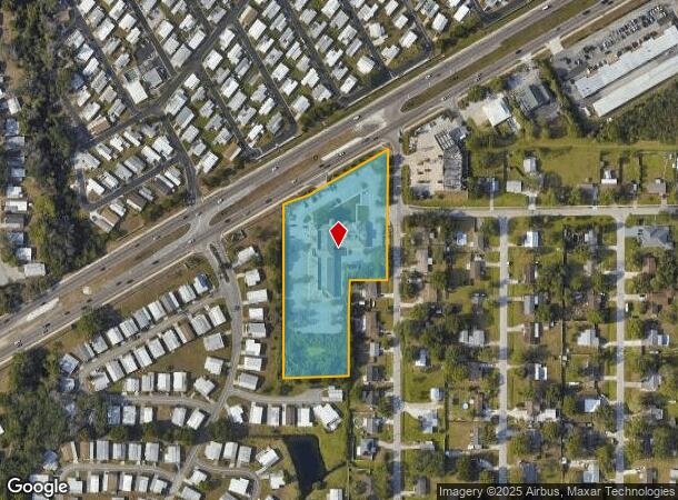
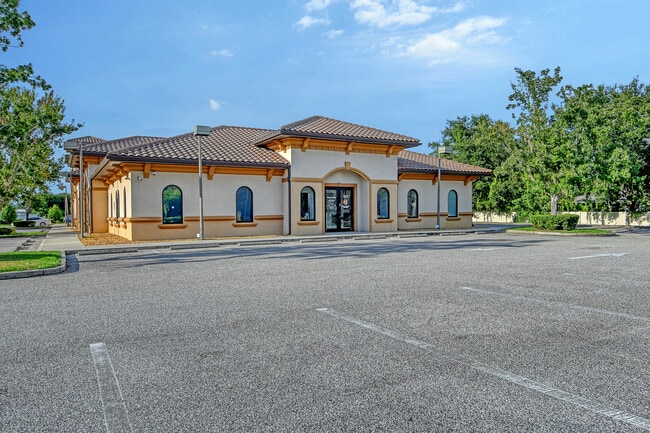
This Property Is For Sale
NEARBY LISTINGS FOR SALE OR LEASE
-
-
View all Ellenton listings for sale on LoopNet.com
Property Detail
7915 Us Highway 301 N
North Port-Sarasota-Bradenton, FL
Wellons Ranch Estates
8263-0005-9
PARCEL 1: BEG AT THE NWLY COR OF LOT 35, OF WELLONS RANCH ESTATES, UNIT ONE, AS REC IN PB 11 PGS 40-41 OF THE PRMCF; TH N ALG THE EXT OF THE W LN OF SD LOT 35, A DIST OF 250.65
Medicalbuilding
Manatee
X
Florida
12081C0186F
35
2023
4.05 AC
2025
Manatee
001907
Tampa/St Petersburg
32,860 SF
DEMOGRAPHICS near 7915 Us Highway 301 N
1 Mile
3 Mile
5 Mile
2024 Total Population
7,441
47,003
109,073
2029 Population
8,763
55,155
127,918
Pop Growth 2024-2029
+ 17.77%
+ 17.34%
+ 17.28%
Average Age
62
48
45
2024 Total Households
3,999
19,786
43,514
HH Growth 2024-2029
+ 17.03%
+ 16.52%
+ 16.44%
Median Household Inc
$47,434
$75,269
$72,325
Avg Household Size
1.80
2.30
2.40
2024 Avg HH Vehicles
1.00
2.00
2.00
Median Home Value
$93,958
$286,492
$294,205
Median Year Built
1986
2005
2002
Nearby Places
Map Layers
Map Styles
 Street
 Aerial
- Restaurants
- Banks
- Shops
- Fitness
- Groceries
PUBLIC TRANSPORTATION
AIRPORT
Sarasota/Bradenton International
DRIVE
WALK
Distance
Sarasota/Bradenton International
30 min
15.7 mi
St Pete-Clearwater International
DRIVE
WALK
Distance
St Pete-Clearwater International
50 min
38.1 mi
Tampa International
DRIVE
WALK
Distance
Tampa International
61 min
47.4 mi
Freight Ports
Port Manatee
DRIVE
WALK
Distance
Port Manatee
20 min
11.3 mi
Nearby Properties
Address
Land Use
TOTAL SIZE
Lot Size
Zoning
Address
Land Use
TOTAL SIZE
Lot Size
Zoning
622,266 SF
68.76 AC
PD-MU
Address
Land Use
TOTAL SIZE
Lot Size
Zoning
513,465 SF
78.39 AC
PD-MU
Address
Land Use
TOTAL SIZE
Lot Size
Zoning
707,409 SF
27.98 AC
PD-MU
Address
Land Use
TOTAL SIZE
Lot Size
Zoning
359,241 SF
27.68 AC
PD-MU
Address
Land Use
TOTAL SIZE
Lot Size
Zoning
294,300 SF
10.33 AC
PD-MU
Address
Land Use
TOTAL SIZE
Lot Size
Zoning
319,679 SF
31.78 AC
BR_R-1
Address
Land Use
TOTAL SIZE
Lot Size
Zoning
225,768 SF
18.47 AC
BR_R-1
Address
Land Use
TOTAL SIZE
Lot Size
Zoning
313,422 SF
47.93 AC
PD-C
Address
Land Use
TOTAL SIZE
Lot Size
Zoning
456,375 SF
112.07 AC
PD-MU
Address
Land Use
TOTAL SIZE
Lot Size
Zoning
270,900 SF
44.35 AC
PD-MU
Address
Land Use
TOTAL SIZE
Lot Size
Zoning
456,317 SF
46.75 AC
PD-R
Address
Land Use
TOTAL SIZE
Lot Size
Zoning
312,546 SF
39.60 AC
A-1 SUBURB
Address
Land Use
TOTAL SIZE
Lot Size
Zoning
191,100 SF
30.35 AC
PD-C
Address
Land Use
TOTAL SIZE
Lot Size
Zoning
220,706 SF
24.13 AC
PD-C, A-1
Address
Land Use
TOTAL SIZE
Lot Size
Zoning
64,800 SF
8.19 AC
Address
Land Use
TOTAL SIZE
Lot Size
Zoning
185,272 SF
18.11 AC
PD-R
Address
Land Use
TOTAL SIZE
Lot Size
Zoning
13,621 SF
61.72 AC
PD-RV,RSF-
Address
Land Use
TOTAL SIZE
Lot Size
Zoning
61,770 SF
79.85 AC
A,A-1
Address
Land Use
TOTAL SIZE
Lot Size
Zoning
66,063 SF
9.24 AC
PD-C
Address
Land Use
TOTAL SIZE
Lot Size
Zoning
59,222 SF
4.49 AC
PD-C
Address
Land Use
TOTAL SIZE
Lot Size
Zoning
65,761 SF
11.91 AC
BR_SCC
Address
Land Use
TOTAL SIZE
Lot Size
Zoning
33.49 AC
Address
Land Use
TOTAL SIZE
Lot Size
Zoning
56,442 SF
6.18 AC
GC GENERA
Address
Land Use
TOTAL SIZE
Lot Size
Zoning
138,258 SF
9.59 AC
PD-MU
Address
Land Use
TOTAL SIZE
Lot Size
Zoning
61,721 SF
5.50 AC
PD-C
Address
Land Use
TOTAL SIZE
Lot Size
Zoning
128,400 SF
24.27 AC
A-1 SUBURB
Address
Land Use
TOTAL SIZE
Lot Size
Zoning
36,002 SF
4.41 AC
PD-C
Address
Land Use
TOTAL SIZE
Lot Size
Zoning
5,744 SF
12.60 AC
RSMH-6
Address
Land Use
TOTAL SIZE
Lot Size
Zoning
7.86 AC
PD-MU
The World's #1 Commercial Real Estate Marketplace
Connect with us
© 2026 CoStar Group
The information above has been obtained from sources believed reliable. While we do not doubt its accuracy we have not verified it and make no guarantee, warranty or representation about it. It is your responsibility to independently confirm its accuracy and completeness. Any projections, opinions, assumptions, or estimates used are for example only and do not represent the current or future performance of the property. The value of this transaction to you depends on tax and other factors which should be evaluated by your tax, financial, and legal advisors. You and your advisors should conduct a careful, independent investigation of the property to determine to your satisfaction the suitability of the property for your needs.