Property Record
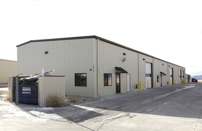
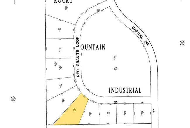
7917 Red Granite Loop, Colorado Springs, CO 80939

NEARBY LISTINGS FOR SALE OR LEASE
Property Detail
7917 Red Granite Loop
Colorado Springs, CO
Rocky Mountain Industrial Park Fil No 1
53333-01-007
LOT 6 BLK 2 ROCKY MOUNTAIN INDUSTRIAL PARK FIL NO 1
Warehouse
El Paso
X
Colorado
08041C0756G
6
2024
1.61 AC
2025
Northeast
005122
Colorado Springs
13,200 SF
DEMOGRAPHICS near 7917 Red Granite Loop
1 Mile
3 Mile
5 Mile
2024 Total Population
7,731
55,253
160,720
2029 Population
8,076
57,519
167,879
Pop Growth 2024-2029
+ 4.46%
+ 4.10%
+ 4.45%
Average Age
33
37
37
2024 Total Households
2,567
20,219
60,629
HH Growth 2024-2029
+ 4.60%
+ 4.35%
+ 4.64%
Median Household Inc
$98,476
$84,073
$79,055
Avg Household Size
3.00
2.70
2.60
2024 Avg HH Vehicles
2.00
2.00
2.00
Median Home Value
$363,288
$349,812
$359,191
Median Year Built
2005
1996
1992
Nearby Places
Map Layers
Map Styles
 Street
 Aerial
- Restaurants
- Banks
- Shops
- Fitness
- Groceries
PUBLIC TRANSPORTATION
AIRPORT
City of Colorado Springs Municipal
DRIVE
WALK
Distance
City of Colorado Springs Municipal
14 min
5.7 mi
Freight Ports
Tulsa Port Of Catoosa
DRIVE
WALK
Distance
Tulsa Port Of Catoosa
731 min
686.2 mi
Nearby Properties
Address
Land Use
TOTAL SIZE
Lot Size
Zoning
Address
Land Use
TOTAL SIZE
Lot Size
Zoning
8,806 SF
124.24 AC
PZ
Address
Land Use
TOTAL SIZE
Lot Size
Zoning
126,860 SF
23.92 AC
MX-N/CR AO
Address
Land Use
TOTAL SIZE
Lot Size
Zoning
126,756 SF
12.67 AC
PUD CAD-O
Address
Land Use
TOTAL SIZE
Lot Size
Zoning
87,577 SF
14.24 AC
CS CAD-O
Address
Land Use
TOTAL SIZE
Lot Size
Zoning
8,096 SF
123.01 AC
PF APZ2 AO
Address
Land Use
TOTAL SIZE
Lot Size
Zoning
86,290 SF
8.01 AC
I-2 CAD-O
Address
Land Use
TOTAL SIZE
Lot Size
Zoning
75,169 SF
122.93 AC
I-3 CAD-O
Address
Land Use
TOTAL SIZE
Lot Size
Zoning
35,806 SF
4.41 AC
MX-M CU AO
Address
Land Use
TOTAL SIZE
Lot Size
Zoning
45,328 SF
3.87 AC
R-4 CAD-O
Address
Land Use
TOTAL SIZE
Lot Size
Zoning
45,579 SF
4.50 AC
MX-M AO
Address
Land Use
TOTAL SIZE
Lot Size
Zoning
43,800 SF
7 AC
R-1 6 CU A
Address
Land Use
TOTAL SIZE
Lot Size
Zoning
18,277 SF
5.80 AC
MX-M AO
Address
Land Use
TOTAL SIZE
Lot Size
Zoning
109,042 SF
15.56 AC
UNK
Address
Land Use
TOTAL SIZE
Lot Size
Zoning
31,201 SF
5.08 AC
PF AO
Address
Land Use
TOTAL SIZE
Lot Size
Zoning
327,692 SF
16.30 AC
MX-N APZ2
Address
Land Use
TOTAL SIZE
Lot Size
Zoning
47,943 SF
6.15 AC
I-2 CAD-O
Address
Land Use
TOTAL SIZE
Lot Size
Zoning
353,072 SF
14.98 AC
CS CAD-O
Address
Land Use
TOTAL SIZE
Lot Size
Zoning
52,568 SF
15 AC
RS-6000 CA
Address
Land Use
TOTAL SIZE
Lot Size
Zoning
359,481 SF
12.70 AC
CR RS-5000
Address
Land Use
TOTAL SIZE
Lot Size
Zoning
179,897 SF
19.51 AC
MX-M AO
Address
Land Use
TOTAL SIZE
Lot Size
Zoning
34,250 SF
8.74 AC
PUD CAD-O
Address
Land Use
TOTAL SIZE
Lot Size
Zoning
210,753 SF
20.68 AC
MX-M CU AP
Address
Land Use
TOTAL SIZE
Lot Size
Zoning
119,962 SF
14.06 AC
CR CAD-O
Address
Land Use
TOTAL SIZE
Lot Size
Zoning
97,258 SF
5 AC
PDZ APZ1 A
Address
Land Use
TOTAL SIZE
Lot Size
Zoning
15,598 SF
4.06 AC
RS-6000 CA
Address
Land Use
TOTAL SIZE
Lot Size
Zoning
157,253 SF
17.33 AC
MX-M AO
Address
Land Use
TOTAL SIZE
Lot Size
Zoning
234,628 SF
9.41 AC
R-5 AO
Address
Land Use
TOTAL SIZE
Lot Size
Zoning
20,000 SF
5.96 AC
I-2 CAD-O
Address
Land Use
TOTAL SIZE
Lot Size
Zoning
9,060 SF
13.75 AC
RM-12 CAD-
Address
Land Use
TOTAL SIZE
Lot Size
Zoning
4,819 SF
53.38 AC
RR-5 CAD-O
The World's #1 Commercial Real Estate Marketplace
Connect with us
© 2025 CoStar Group
The information above has been obtained from sources believed reliable. While we do not doubt its accuracy we have not verified it and make no guarantee, warranty or representation about it. It is your responsibility to independently confirm its accuracy and completeness. Any projections, opinions, assumptions, or estimates used are for example only and do not represent the current or future performance of the property. The value of this transaction to you depends on tax and other factors which should be evaluated by your tax, financial, and legal advisors. You and your advisors should conduct a careful, independent investigation of the property to determine to your satisfaction the suitability of the property for your needs.