Property Record
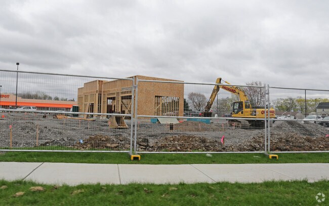
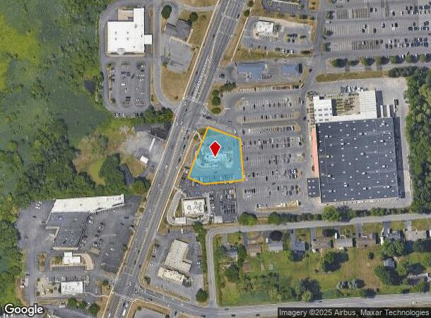
7918 Brewerton Rd, Cicero, NY 13039
NEARBY LISTINGS FOR SALE OR LEASE
Property Detail
7918 Brewerton Rd
312289-043-000-0001-010-003-0000
Onondaga
Restaurantdrivein
New York
X
10.003
36067C0113F
1.15 AC
2025
NE Outer Onondaga County
2024
Syracuse
010301
Syracuse, NY
2,000 SF
DEMOGRAPHICS near 7918 Brewerton Rd
1 Mile
3 Mile
5 Mile
2024 Total Population
4,999
40,075
79,400
2029 Population
4,837
38,882
77,222
Pop Growth 2024-2029
(3.24%)
(2.98%)
(2.74%)
Average Age
42
42
42
2024 Total Households
2,035
16,613
33,523
HH Growth 2024-2029
(3.44%)
(3.15%)
(2.93%)
Median Household Inc
$76,498
$83,739
$75,570
Avg Household Size
2.40
2.40
2.30
2024 Avg HH Vehicles
2.00
2.00
2.00
Median Home Value
$154,179
$168,043
$166,161
Median Year Built
1970
1972
1970
Nearby Places
- Restaurants
- Banks
- Shops
- Fitness
- Groceries
PUBLIC TRANSPORTATION
COMMUTER RAIL
DRIVE
WALK
Distance
14 min
8.3 mi
DRIVE
WALK
Distance
14 min
8.3 mi
AIRPORT
Syracuse Hancock International
DRIVE
WALK
Distance
Syracuse Hancock International
12 min
5.4 mi
SALE & LEASE HISTORY
LISTING DATE
SALE/LEASE

Feb 16, 2021
For Sale
Aug 18, 2020
For Sale
Nearby Properties
Address
Land Use
TOTAL SIZE
Lot Size
Zoning
Address
Land Use
TOTAL SIZE
Lot Size
Zoning
256,727 SF
70.21 AC
Address
Land Use
TOTAL SIZE
Lot Size
Zoning
439,670 SF
74.73 AC
C-G
Address
Land Use
TOTAL SIZE
Lot Size
Zoning
157,010 SF
36.98 AC
Address
Land Use
TOTAL SIZE
Lot Size
Zoning
218,439 SF
18.85 AC
Address
Land Use
TOTAL SIZE
Lot Size
Zoning
246,172 SF
16.65 AC
Address
Land Use
TOTAL SIZE
Lot Size
Zoning
203,345 SF
18.17 AC
Address
Land Use
TOTAL SIZE
Lot Size
Zoning
8,417 SF
13.95 AC
Address
Land Use
TOTAL SIZE
Lot Size
Zoning
84,048 SF
19.42 AC
Address
Land Use
TOTAL SIZE
Lot Size
Zoning
125,400 SF
18.11 AC
GC
Address
Land Use
TOTAL SIZE
Lot Size
Zoning
120,068 SF
9.26 AC
GCPLUS
Address
Land Use
TOTAL SIZE
Lot Size
Zoning
141,472 SF
12.38 AC
C-G
Address
Land Use
TOTAL SIZE
Lot Size
Zoning
92,844 SF
14.26 AC
C-G
Address
Land Use
TOTAL SIZE
Lot Size
Zoning
103,005 SF
12.58 AC
Address
Land Use
TOTAL SIZE
Lot Size
Zoning
27,044 SF
25.20 AC
C-G
Address
Land Use
TOTAL SIZE
Lot Size
Zoning
66,538 SF
18.24 AC
Address
Land Use
TOTAL SIZE
Lot Size
Zoning
63,140 SF
25.52 AC
Address
Land Use
TOTAL SIZE
Lot Size
Zoning
33,180 SF
23.85 AC
GCPLUS
Address
Land Use
TOTAL SIZE
Lot Size
Zoning
81,439 SF
15.48 AC
Address
Land Use
TOTAL SIZE
Lot Size
Zoning
57,052 SF
16.82 AC
Address
Land Use
TOTAL SIZE
Lot Size
Zoning
92,936 SF
9.23 AC
GCPLUS
Address
Land Use
TOTAL SIZE
Lot Size
Zoning
90,292 SF
9.17 AC
GCPLUS
Address
Land Use
TOTAL SIZE
Lot Size
Zoning
1.66 AC
06 - INDUS
Address
Land Use
TOTAL SIZE
Lot Size
Zoning
67,143 SF
3.91 AC
Address
Land Use
TOTAL SIZE
Lot Size
Zoning
82,661 SF
15 AC
Address
Land Use
TOTAL SIZE
Lot Size
Zoning
41,292 SF
8.50 AC
05 - COMME
Address
Land Use
TOTAL SIZE
Lot Size
Zoning
2,404 SF
9.73 AC
Address
Land Use
TOTAL SIZE
Lot Size
Zoning
44,560 SF
2 AC
06 - INDUS
Address
Land Use
TOTAL SIZE
Lot Size
Zoning
78,203 SF
0.01 AC
06 - INDUS
Address
Land Use
TOTAL SIZE
Lot Size
Zoning
57,953 SF
0.01 AC
06 - INDUS
The World's #1 Commercial Real Estate Marketplace
Connect with us
© 2025 CoStar Group
The information above has been obtained from sources believed reliable. While we do not doubt its accuracy we have not verified it and make no guarantee, warranty or representation about it. It is your responsibility to independently confirm its accuracy and completeness. Any projections, opinions, assumptions, or estimates used are for example only and do not represent the current or future performance of the property. The value of this transaction to you depends on tax and other factors which should be evaluated by your tax, financial, and legal advisors. You and your advisors should conduct a careful, independent investigation of the property to determine to your satisfaction the suitability of the property for your needs.