Property Record
7918 Highway 70, North Little Rock, AR 72117
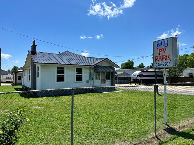
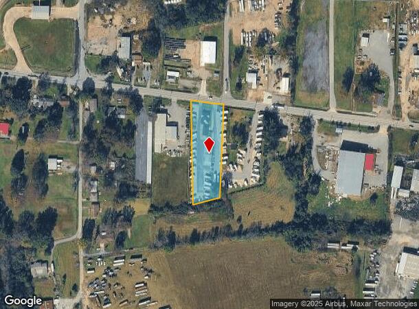
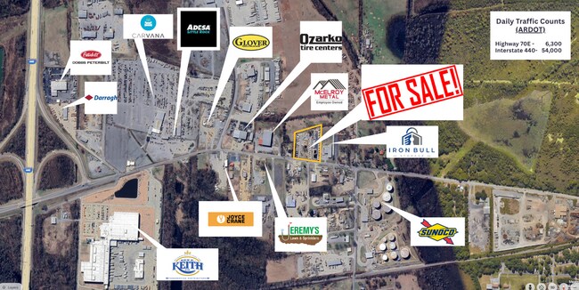
This Property Is For Sale
NEARBY LISTINGS FOR SALE OR LEASE
-
-
View all North Little Rock listings for sale on LoopNet.com
Property Detail
7918 Highway 70
Little Rock-North Little Rock-Conway, AR
Braddocks J S Sub Div
23R-014-06-068-00
ALL THAT PT BLK 31 S OF LR GALLOWAY PIKE & N OF CLN EXC COM INTERS ELY LN BLK 31 & SLY R/W LN HWY 70 TH N84*W AL SLY LN HWY 140 TO POB TH S00*W472.03 S75*W180 TO WLN BLK 31 TH N00*E AL WLN 534 TO SLY R/W LN SD HWY TH S84*E AL R/W 180 TO POB
Warehouse
Pulaski
X
Arkansas
05119C0368G
31
2025
1.49 AC
2025
North Little Rock
003900
Little Rock/N Little Rock
3,619 SF
DEMOGRAPHICS near 7918 Highway 70
1 Mile
3 Mile
5 Mile
2024 Total Population
668
10,524
43,165
2029 Population
678
10,729
43,485
Pop Growth 2024-2029
+ 1.50%
+ 1.95%
+ 0.74%
Average Age
39
38
41
2024 Total Households
275
4,299
18,731
HH Growth 2024-2029
+ 1.82%
+ 1.91%
+ 0.81%
Median Household Inc
$8,477
$29,774
$49,886
Avg Household Size
2.40
2.30
2.20
2024 Avg HH Vehicles
2.00
2.00
2.00
Median Home Value
$60,074
$82,784
$157,797
Median Year Built
1967
1973
1975
Nearby Places
Map Layers
Map Styles
 Street
 Aerial
- Restaurants
- Banks
- Shops
- Fitness
- Groceries
PUBLIC TRANSPORTATION
COMMUTER RAIL
Little Rock Union Station (Texas Eagle - Amtrak)
DRIVE
WALK
Distance
Little Rock Union Station (Texas Eagle - Amtrak)
12 min
7.2 mi
AIRPORT
Bill and Hillary Clinton Ntl/Adams Field
DRIVE
WALK
Distance
Bill and Hillary Clinton Ntl/Adams Field
10 min
8.0 mi
Freight Ports
Port of Shreveport
DRIVE
WALK
Distance
Port of Shreveport
258 min
241.0 mi
Nearby Properties
Address
Land Use
TOTAL SIZE
Lot Size
Zoning
Address
Land Use
TOTAL SIZE
Lot Size
Zoning
18,133 SF
71.16 AC
Address
Land Use
TOTAL SIZE
Lot Size
Zoning
379,202 SF
118.65 AC
Address
Land Use
TOTAL SIZE
Lot Size
Zoning
725,800 SF
128.27 AC
Address
Land Use
TOTAL SIZE
Lot Size
Zoning
82,978 SF
12.54 AC
Address
Land Use
TOTAL SIZE
Lot Size
Zoning
36,711 SF
28.35 AC
Address
Land Use
TOTAL SIZE
Lot Size
Zoning
157,477 SF
9.35 AC
Address
Land Use
TOTAL SIZE
Lot Size
Zoning
4,112 SF
15.95 AC
Address
Land Use
TOTAL SIZE
Lot Size
Zoning
157,784 SF
66.14 AC
Address
Land Use
TOTAL SIZE
Lot Size
Zoning
6,460 SF
24.35 AC
Address
Land Use
TOTAL SIZE
Lot Size
Zoning
207,760 SF
13.31 AC
Address
Land Use
TOTAL SIZE
Lot Size
Zoning
70,344 SF
19.22 AC
Address
Land Use
TOTAL SIZE
Lot Size
Zoning
102,858 SF
10.19 AC
Address
Land Use
TOTAL SIZE
Lot Size
Zoning
85,948 SF
3.29 AC
Address
Land Use
TOTAL SIZE
Lot Size
Zoning
38,160 SF
14 AC
Address
Land Use
TOTAL SIZE
Lot Size
Zoning
51,758 SF
17.08 AC
Address
Land Use
TOTAL SIZE
Lot Size
Zoning
33,952 SF
6.46 AC
Address
Land Use
TOTAL SIZE
Lot Size
Zoning
40,286 SF
4.52 AC
Address
Land Use
TOTAL SIZE
Lot Size
Zoning
4,153 SF
3.06 AC
Address
Land Use
TOTAL SIZE
Lot Size
Zoning
141,026 SF
12.49 AC
Address
Land Use
TOTAL SIZE
Lot Size
Zoning
870 SF
18.01 AC
Address
Land Use
TOTAL SIZE
Lot Size
Zoning
Address
Land Use
TOTAL SIZE
Lot Size
Zoning
35,343 SF
37.27 AC
Address
Land Use
TOTAL SIZE
Lot Size
Zoning
2,999 SF
28.40 AC
Address
Land Use
TOTAL SIZE
Lot Size
Zoning
25,608 SF
2.42 AC
Address
Land Use
TOTAL SIZE
Lot Size
Zoning
178,750 SF
10.75 AC
Address
Land Use
TOTAL SIZE
Lot Size
Zoning
19,200 SF
23.38 AC
Address
Land Use
TOTAL SIZE
Lot Size
Zoning
41,384 SF
27.12 AC
Address
Land Use
TOTAL SIZE
Lot Size
Zoning
Address
Land Use
TOTAL SIZE
Lot Size
Zoning
55,160 SF
16.50 AC
Address
Land Use
TOTAL SIZE
Lot Size
Zoning
35,485 SF
16 AC
The World's #1 Commercial Real Estate Marketplace
Connect with us
© 2025 CoStar Group
The information above has been obtained from sources believed reliable. While we do not doubt its accuracy we have not verified it and make no guarantee, warranty or representation about it. It is your responsibility to independently confirm its accuracy and completeness. Any projections, opinions, assumptions, or estimates used are for example only and do not represent the current or future performance of the property. The value of this transaction to you depends on tax and other factors which should be evaluated by your tax, financial, and legal advisors. You and your advisors should conduct a careful, independent investigation of the property to determine to your satisfaction the suitability of the property for your needs.