Property Record
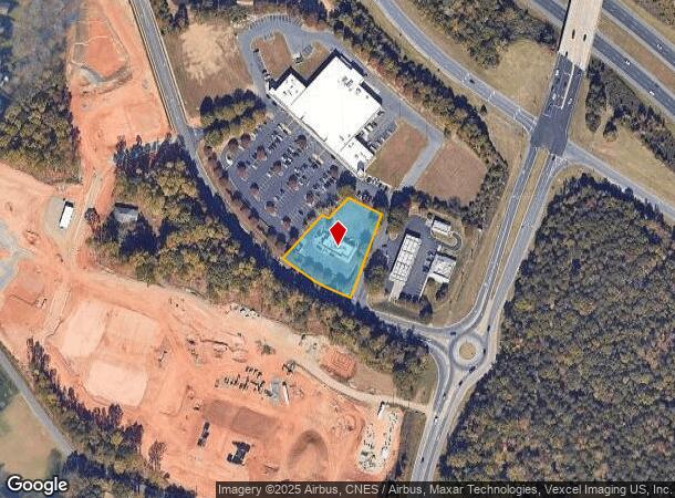
7920 Cambridge Commons Dr, Charlotte, NC 28215
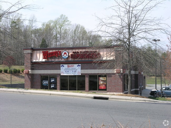

This Property Is For Sale
NEARBY LISTINGS FOR SALE OR LEASE
Property Detail
7920 Cambridge Commons Dr
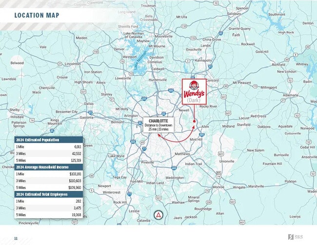
Charlotte-Concord-Gastonia, NC-SC
Cambridge Commons Shopping Cen
111-074-27
L2 M37-903
Restaurantdrivein
Mecklenburg
X
North Carolina
3710550500M
2
2024
1.02 AC
2025
East
005619
Charlotte
3,183 SF
DEMOGRAPHICS near 7920 Cambridge Commons Dr
1 Mile
3 Mile
5 Mile
2024 Total Population
6,663
36,572
117,220
2029 Population
7,122
39,614
125,472
Pop Growth 2024-2029
+ 6.89%
+ 8.32%
+ 7.04%
Average Age
38
37
37
2024 Total Households
2,400
12,462
40,800
HH Growth 2024-2029
+ 6.88%
+ 7.98%
+ 6.68%
Median Household Inc
$79,100
$74,174
$74,451
Avg Household Size
2.70
2.80
2.80
2024 Avg HH Vehicles
2.00
2.00
2.00
Median Home Value
$260,501
$281,158
$286,706
Median Year Built
1996
2003
1997
Nearby Places
Map Layers
Map Styles
 Street
 Aerial
- Restaurants
- Banks
- Shops
- Fitness
- Groceries
PUBLIC TRANSPORTATION
AIRPORT
Concord-Padgett Regional
DRIVE
WALK
Distance
Concord-Padgett Regional
19 min
12.8 mi
Charlotte/Douglas International
DRIVE
WALK
Distance
Charlotte/Douglas International
39 min
25.1 mi
Nearby Properties
Address
Land Use
TOTAL SIZE
Lot Size
Zoning
Address
Land Use
TOTAL SIZE
Lot Size
Zoning
261,708 SF
34.03 AC
Address
Land Use
TOTAL SIZE
Lot Size
Zoning
315,436 SF
23.89 AC
R3
Address
Land Use
TOTAL SIZE
Lot Size
Zoning
290,268 SF
19.96 AC
R17MFCD
Address
Land Use
TOTAL SIZE
Lot Size
Zoning
187,371 SF
7.31 AC
Address
Land Use
TOTAL SIZE
Lot Size
Zoning
333,774 SF
64.04 AC
I
Address
Land Use
TOTAL SIZE
Lot Size
Zoning
184,955 SF
5.78 AC
Address
Land Use
TOTAL SIZE
Lot Size
Zoning
169,115 SF
4.86 AC
Address
Land Use
TOTAL SIZE
Lot Size
Zoning
127,078 SF
10.66 AC
O-I
Address
Land Use
TOTAL SIZE
Lot Size
Zoning
96,071 SF
7.44 AC
Address
Land Use
TOTAL SIZE
Lot Size
Zoning
239,983 SF
21.41 AC
I-G(CD)
Address
Land Use
TOTAL SIZE
Lot Size
Zoning
32,237 SF
29.32 AC
GC
Address
Land Use
TOTAL SIZE
Lot Size
Zoning
58,134 SF
5.08 AC
IGCUD
Address
Land Use
TOTAL SIZE
Lot Size
Zoning
104,386 SF
13 AC
R4
Address
Land Use
TOTAL SIZE
Lot Size
Zoning
80,528 SF
10.01 AC
PUD
Address
Land Use
TOTAL SIZE
Lot Size
Zoning
104,214 SF
1.69 AC
MUDD-O
Address
Land Use
TOTAL SIZE
Lot Size
Zoning
62,619 SF
11.93 AC
I-G(CD)
Address
Land Use
TOTAL SIZE
Lot Size
Zoning
84,164 SF
26 AC
R3
Address
Land Use
TOTAL SIZE
Lot Size
Zoning
49,878 SF
6.11 AC
Address
Land Use
TOTAL SIZE
Lot Size
Zoning
105,138 SF
4.09 AC
R-8MF
Address
Land Use
TOTAL SIZE
Lot Size
Zoning
68,653 SF
17.30 AC
R3
Address
Land Use
TOTAL SIZE
Lot Size
Zoning
69,108 SF
14.95 AC
I-G(CD)
Address
Land Use
TOTAL SIZE
Lot Size
Zoning
3,614 SF
7.57 AC
NS
Address
Land Use
TOTAL SIZE
Lot Size
Zoning
46,438 SF
7.90 AC
B1SCD
Address
Land Use
TOTAL SIZE
Lot Size
Zoning
54,051 SF
25.06 AC
CR
Address
Land Use
TOTAL SIZE
Lot Size
Zoning
720 SF
35.60 AC
O-2(CD)
Address
Land Use
TOTAL SIZE
Lot Size
Zoning
75,631 SF
4.30 AC
R4
Address
Land Use
TOTAL SIZE
Lot Size
Zoning
188.38 AC
R-3
Address
Land Use
TOTAL SIZE
Lot Size
Zoning
5,528 SF
174.55 AC
O-1
Address
Land Use
TOTAL SIZE
Lot Size
Zoning
14,388 SF
309.37 AC
R3
Address
Land Use
TOTAL SIZE
Lot Size
Zoning
15,316 SF
2.48 AC
PUD
The World's #1 Commercial Real Estate Marketplace
Connect with us
© 2025 CoStar Group
The information above has been obtained from sources believed reliable. While we do not doubt its accuracy we have not verified it and make no guarantee, warranty or representation about it. It is your responsibility to independently confirm its accuracy and completeness. Any projections, opinions, assumptions, or estimates used are for example only and do not represent the current or future performance of the property. The value of this transaction to you depends on tax and other factors which should be evaluated by your tax, financial, and legal advisors. You and your advisors should conduct a careful, independent investigation of the property to determine to your satisfaction the suitability of the property for your needs.