Property Record
7920 Chapel Hill Rd, Cary, NC 27513
This Property Is For Sale
NEARBY LISTINGS FOR SALE OR LEASE
Property Detail
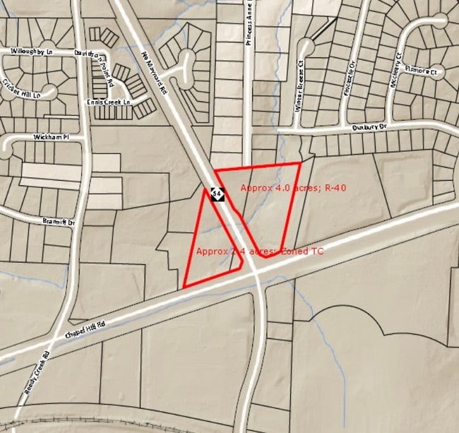
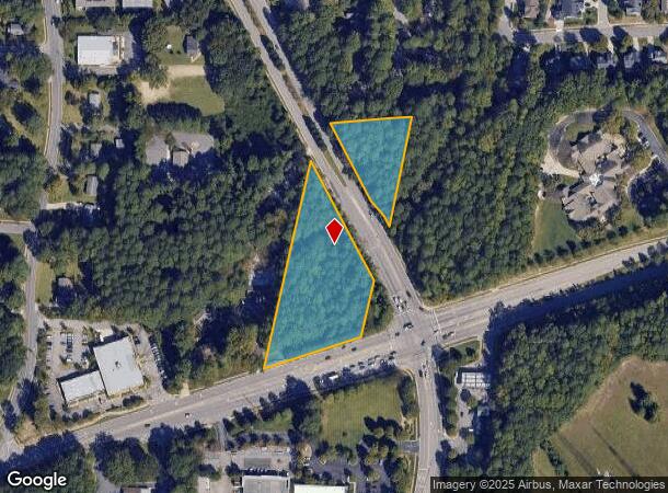
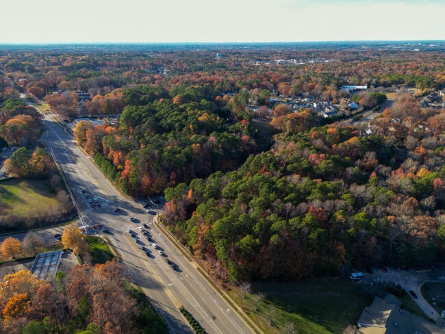
7920 Chapel Hill Rd
Raleigh, NC
MAYNARD LD
0764.16-94-8683-000
Wake
Vacantlandnec
North Carolina
X
2
3720076400K
2.99 AC
0
Cary
2025
Raleigh/Durham
053520
DEMOGRAPHICS near 7920 Chapel Hill Rd
1 Mile
3 Mile
5 Mile
2024 Total Population
10,347
75,554
188,933
2029 Population
11,234
81,991
205,242
Pop Growth 2024-2029
+ 8.57%
+ 8.52%
+ 8.63%
Average Age
37
38
38
2024 Total Households
3,920
32,806
80,564
HH Growth 2024-2029
+ 8.57%
+ 8.56%
+ 8.73%
Median Household Inc
$82,997
$79,112
$85,349
Avg Household Size
2.50
2.20
2.20
2024 Avg HH Vehicles
2.00
2.00
2.00
Median Home Value
$341,854
$371,821
$416,584
Median Year Built
1986
1990
1992
Nearby Places
Map Layers
Map Styles
 Street
 Aerial
- Restaurants
- Banks
- Shops
- Fitness
- Groceries
PUBLIC TRANSPORTATION
COMMUTER RAIL
Cary Station (Piedmont - North Carolina by Train (NC Train))
DRIVE
WALK
Distance
Cary Station (Piedmont - North Carolina by Train (NC Train))
3 min
1.5 mi
Raleigh Union Station (Piedmont - North Carolina by Train (NC Train))
DRIVE
WALK
Distance
Raleigh Union Station (Piedmont - North Carolina by Train (NC Train))
13 min
7.4 mi
AIRPORT
Raleigh-Durham International
DRIVE
WALK
Distance
Raleigh-Durham International
15 min
9.7 mi
Freight Ports
Port of Wilmington
DRIVE
WALK
Distance
Port of Wilmington
160 min
140.4 mi
Nearby Properties
Address
Land Use
TOTAL SIZE
Lot Size
Zoning
Address
Land Use
TOTAL SIZE
Lot Size
Zoning
770,311 SF
80.70 AC
PD
Address
Land Use
TOTAL SIZE
Lot Size
Zoning
693,180 SF
17.61 AC
GCM
Address
Land Use
TOTAL SIZE
Lot Size
Zoning
12,850 SF
96.80 AC
OX-12
Address
Land Use
TOTAL SIZE
Lot Size
Zoning
1,039,527 SF
22.85 AC
OX-7
Address
Land Use
TOTAL SIZE
Lot Size
Zoning
439,439 SF
30.59 AC
OICU
Address
Land Use
TOTAL SIZE
Lot Size
Zoning
433,914 SF
11.81 AC
MXD
Address
Land Use
TOTAL SIZE
Lot Size
Zoning
416,361 SF
38.41 AC
ORD
Address
Land Use
TOTAL SIZE
Lot Size
Zoning
378,159 SF
22.40 AC
OX-7
Address
Land Use
TOTAL SIZE
Lot Size
Zoning
429,107 SF
13.67 AC
RMFP
Address
Land Use
TOTAL SIZE
Lot Size
Zoning
395,263 SF
6.07 AC
CX-5
Address
Land Use
TOTAL SIZE
Lot Size
Zoning
312,475 SF
21.74 AC
RMFP
Address
Land Use
TOTAL SIZE
Lot Size
Zoning
453,970 SF
41.48 AC
RMF-C
Address
Land Use
TOTAL SIZE
Lot Size
Zoning
554,316 SF
42.79 AC
ORD
Address
Land Use
TOTAL SIZE
Lot Size
Zoning
308,622 SF
14.34 AC
CX-5
Address
Land Use
TOTAL SIZE
Lot Size
Zoning
220,152 SF
67.76 AC
OIM
Address
Land Use
TOTAL SIZE
Lot Size
Zoning
358,137 SF
22.39 AC
RMFP
Address
Land Use
TOTAL SIZE
Lot Size
Zoning
402,447 SF
49.88 AC
GC
Address
Land Use
TOTAL SIZE
Lot Size
Zoning
350,189 SF
15.77 AC
PD
Address
Land Use
TOTAL SIZE
Lot Size
Zoning
359,022 SF
21.46 AC
OX-3
Address
Land Use
TOTAL SIZE
Lot Size
Zoning
211,387 SF
36.72 AC
OX-3
Address
Land Use
TOTAL SIZE
Lot Size
Zoning
414,214 SF
11.23 AC
OIP
Address
Land Use
TOTAL SIZE
Lot Size
Zoning
357,293 SF
25.23 AC
RX-3
Address
Land Use
TOTAL SIZE
Lot Size
Zoning
269,702 SF
14.66 AC
GCM
Address
Land Use
TOTAL SIZE
Lot Size
Zoning
382,324 SF
14.85 AC
OX-7
Address
Land Use
TOTAL SIZE
Lot Size
Zoning
263,094 SF
36.79 AC
ORD
Address
Land Use
TOTAL SIZE
Lot Size
Zoning
513,738 SF
35.66 AC
OIP
Address
Land Use
TOTAL SIZE
Lot Size
Zoning
290,022 SF
14.76 AC
RX-3
Address
Land Use
TOTAL SIZE
Lot Size
Zoning
242,847 SF
17.75 AC
RX-3
Address
Land Use
TOTAL SIZE
Lot Size
Zoning
473,237 SF
AP
Address
Land Use
TOTAL SIZE
Lot Size
Zoning
364,972 SF
35.18 AC
RMF-C
The World's #1 Commercial Real Estate Marketplace
Connect with us
© 2025 CoStar Group
The information above has been obtained from sources believed reliable. While we do not doubt its accuracy we have not verified it and make no guarantee, warranty or representation about it. It is your responsibility to independently confirm its accuracy and completeness. Any projections, opinions, assumptions, or estimates used are for example only and do not represent the current or future performance of the property. The value of this transaction to you depends on tax and other factors which should be evaluated by your tax, financial, and legal advisors. You and your advisors should conduct a careful, independent investigation of the property to determine to your satisfaction the suitability of the property for your needs.