Property Record
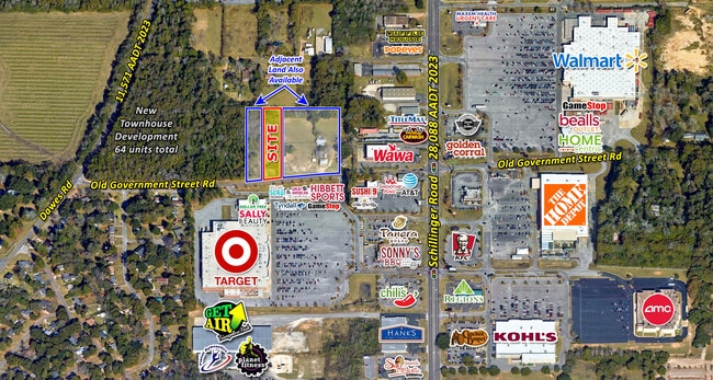
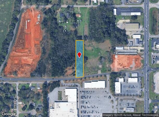
7920 Old Government Street Rd, Mobile, AL 36695
This Property Is For Sale
NEARBY LISTINGS FOR SALE OR LEASE
Property Detail
7920 Old Government Street Rd
Mobile, AL
Airport Acres
27-06-24-4-000-045.001
LOT 18 AIRPORT ACS NO 2 MBK 4/63 #SEC 24 T4S R3W #MP27 06 24 4 000
Vacantlandnec
Mobile
X
Alabama
01097C0536L
18
2025
1.10 AC
2024
Outlying Mobile County
006408
Mobile
DEMOGRAPHICS near 7920 Old Government Street Rd
1 Mile
3 Mile
5 Mile
2024 Total Population
3,361
45,367
112,395
2029 Population
3,361
44,353
109,613
Pop Growth 2024-2029
0.00%
(2.24%)
(2.48%)
Average Age
38
38
39
2024 Total Households
1,329
18,199
44,715
HH Growth 2024-2029
0.00%
(2.37%)
(2.59%)
Median Household Inc
$45,971
$53,803
$60,185
Avg Household Size
2.50
2.30
2.40
2024 Avg HH Vehicles
2.00
2.00
2.00
Median Home Value
$142,468
$183,180
$190,589
Median Year Built
1990
1991
1987
Nearby Places
- Restaurants
- Banks
- Shops
- Fitness
- Groceries
PUBLIC TRANSPORTATION
AIRPORT
Mobile Regional
DRIVE
WALK
Distance
Mobile Regional
9 min
2.9 mi
Mobile International
DRIVE
WALK
Distance
Mobile International
23 min
13.7 mi
Freight Ports
Port of Mobile
DRIVE
WALK
Distance
Port of Mobile
25 min
13.4 mi
Nearby Properties
Address
Land Use
TOTAL SIZE
Lot Size
Zoning
Address
Land Use
TOTAL SIZE
Lot Size
Zoning
549,081 SF
15.70 AC
Address
Land Use
TOTAL SIZE
Lot Size
Zoning
142,425 SF
160 AC
Address
Land Use
TOTAL SIZE
Lot Size
Zoning
32,394 SF
40 AC
Address
Land Use
TOTAL SIZE
Lot Size
Zoning
230,009 SF
97.56 AC
Address
Land Use
TOTAL SIZE
Lot Size
Zoning
250,368 SF
314.40 AC
Address
Land Use
TOTAL SIZE
Lot Size
Zoning
25,536 SF
24 AC
Address
Land Use
TOTAL SIZE
Lot Size
Zoning
101,225 SF
142 AC
Address
Land Use
TOTAL SIZE
Lot Size
Zoning
34,801 SF
21.88 AC
Address
Land Use
TOTAL SIZE
Lot Size
Zoning
6,172 SF
23.43 AC
Address
Land Use
TOTAL SIZE
Lot Size
Zoning
26,400 SF
256.19 AC
Address
Land Use
TOTAL SIZE
Lot Size
Zoning
88,588 SF
13.01 AC
Address
Land Use
TOTAL SIZE
Lot Size
Zoning
105,921 SF
17.90 AC
Address
Land Use
TOTAL SIZE
Lot Size
Zoning
119,648 SF
38.21 AC
Address
Land Use
TOTAL SIZE
Lot Size
Zoning
31,608 SF
20.30 AC
Address
Land Use
TOTAL SIZE
Lot Size
Zoning
19,536 SF
14.68 AC
Address
Land Use
TOTAL SIZE
Lot Size
Zoning
18,368 SF
14.70 AC
Address
Land Use
TOTAL SIZE
Lot Size
Zoning
65,356 SF
6.35 AC
Address
Land Use
TOTAL SIZE
Lot Size
Zoning
17,240 SF
12 AC
Address
Land Use
TOTAL SIZE
Lot Size
Zoning
179,142 SF
17.12 AC
Address
Land Use
TOTAL SIZE
Lot Size
Zoning
200,001 SF
20 AC
Address
Land Use
TOTAL SIZE
Lot Size
Zoning
31,728 SF
8.10 AC
Address
Land Use
TOTAL SIZE
Lot Size
Zoning
10,256 SF
17.90 AC
Address
Land Use
TOTAL SIZE
Lot Size
Zoning
54,089 SF
14 AC
Address
Land Use
TOTAL SIZE
Lot Size
Zoning
62,859 SF
6.84 AC
Address
Land Use
TOTAL SIZE
Lot Size
Zoning
63,550 SF
89.09 AC
Address
Land Use
TOTAL SIZE
Lot Size
Zoning
280.05 AC
Address
Land Use
TOTAL SIZE
Lot Size
Zoning
185,520 SF
50.74 AC
Address
Land Use
TOTAL SIZE
Lot Size
Zoning
160,006 SF
113.88 AC
Address
Land Use
TOTAL SIZE
Lot Size
Zoning
4,958 SF
14.09 AC
Address
Land Use
TOTAL SIZE
Lot Size
Zoning
19,340 SF
17.45 AC
The World's #1 Commercial Real Estate Marketplace
Connect with us
© 2025 CoStar Group
The information above has been obtained from sources believed reliable. While we do not doubt its accuracy we have not verified it and make no guarantee, warranty or representation about it. It is your responsibility to independently confirm its accuracy and completeness. Any projections, opinions, assumptions, or estimates used are for example only and do not represent the current or future performance of the property. The value of this transaction to you depends on tax and other factors which should be evaluated by your tax, financial, and legal advisors. You and your advisors should conduct a careful, independent investigation of the property to determine to your satisfaction the suitability of the property for your needs.