Property Record
7920 Old Ocean View Rd, Norfolk, VA 23518

Save to a Folder
{{folder.Name}}
{{folder.ListingIds.length}} Properties
{{folder.ListingIds.length}} Property
Create a New Folder
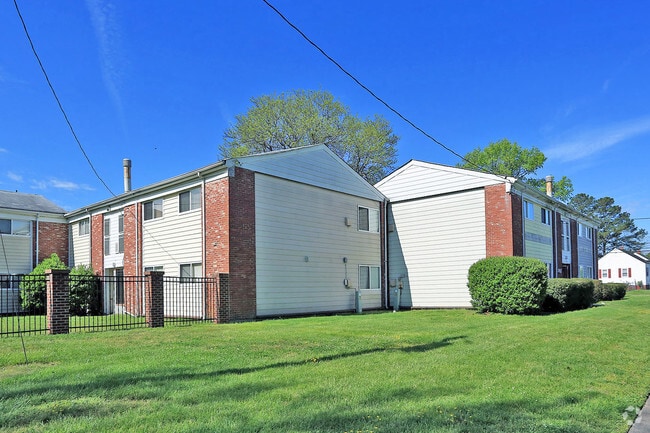
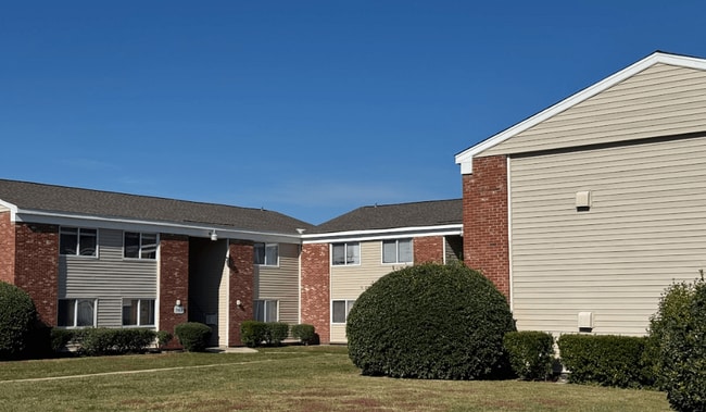
Property Detail
7920 Old Ocean View Rd
Virginia Beach-Chesapeake-Norfolk, VA-NC
LOTS 1, 2 & 3
41127600
Norfolk City
Apartment
Virginia
C2
1-3
B and X Area of moderate flood hazard, usually the area between the limits of the 100-year and 500-year floods.
4.85 AC
2025
Colonial Heights
2025
Hampton Roads
005602
NEARBY LISTINGS FOR SALE OR LEASE
DEMOGRAPHICS near 7920 Old Ocean View Rd
1 mile
3 mile
5 mile
2025 Total Population
15,410
107,355
217,825
2030 Population
15,043
104,868
214,444
Pop Growth 2025-2030
(2.38%)
(2.32%)
(1.55%)
Average Age
38
38
37
2025 Total Households
6,395
44,590
84,810
HH Growth 2025-2030
(2.49%)
(2.43%)
(1.72%)
Median Household Inc
$56,088
$65,875
$64,154
Avg Household Size
2.40
2.30
2.30
2025 Avg HH Vehicles
2.00
2.00
2.00
Median Home Value
$265,144
$295,230
$309,229
Median Year Built
1961
1961
1965
Nearby Places
Map Layers
Map Styles
 Street
 Aerial
Layers
 Traffic
 Biking
Places
Listings with unknown addresses are not visible on the map
- Restaurants
- Banks
- Shops
- Fitness
- Groceries
PUBLIC TRANSPORTATION
COMMUTER RAIL
Norfolk (Northeast Regional - Amtrak)
Drive
Walk
Distance
Norfolk (Northeast Regional - Amtrak)
12 min
6.6 mi
AIRPORT
Norfolk International
Drive
Walk
Distance
Norfolk International
8 min
3.6 mi
Newport News/Williamsburg International
Drive
Walk
Distance
Newport News/Williamsburg International
36 min
24.1 mi
Freight Ports
Virginia Port Authority - Norfolk
Drive
Walk
Distance
Virginia Port Authority - Norfolk
13 min
5.0 mi
SALE & LEASE HISTORY
LISTING DATE
SALE/LEASE

Feb 09, 2022
For Sale
Nearby Properties
Address
Land Use
TOTAL SIZE
Lot Size
Zoning
Address
Land Use
TOTAL SIZE
Lot Size
Zoning
116,476 SF
947.43 AC
Address
Land Use
TOTAL SIZE
Lot Size
Zoning
1,190.45 AC
Address
Land Use
TOTAL SIZE
Lot Size
Zoning
777.89 AC
Address
Land Use
TOTAL SIZE
Lot Size
Zoning
8,423 SF
53.95 AC
Address
Land Use
TOTAL SIZE
Lot Size
Zoning
40.37 AC
R6
Address
Land Use
TOTAL SIZE
Lot Size
Zoning
213 AC
I5
Address
Land Use
TOTAL SIZE
Lot Size
Zoning
321,691 SF
30.58 AC
Address
Land Use
TOTAL SIZE
Lot Size
Zoning
167,279 SF
9.97 AC
IN1
Address
Land Use
TOTAL SIZE
Lot Size
Zoning
6,572 SF
23.41 AC
Address
Land Use
TOTAL SIZE
Lot Size
Zoning
103,496 SF
25.81 AC
IN1
Address
Land Use
TOTAL SIZE
Lot Size
Zoning
1,020 SF
13.45 AC
R11
Address
Land Use
TOTAL SIZE
Lot Size
Zoning
47,832 SF
7.51 AC
C2
Address
Land Use
TOTAL SIZE
Lot Size
Zoning
6,170 SF
18.46 AC
R13
Address
Land Use
TOTAL SIZE
Lot Size
Zoning
19.47 AC
86
Address
Land Use
TOTAL SIZE
Lot Size
Zoning
52,612 SF
4.94 AC
Address
Land Use
TOTAL SIZE
Lot Size
Zoning
27,840 SF
5.80 AC
R11
Address
Land Use
TOTAL SIZE
Lot Size
Zoning
14.02 AC
Address
Land Use
TOTAL SIZE
Lot Size
Zoning
41,754 SF
6.01 AC
Address
Land Use
TOTAL SIZE
Lot Size
Zoning
170,152 SF
6.07 AC
PDMU1
Address
Land Use
TOTAL SIZE
Lot Size
Zoning
6.96 AC
R11
Address
Land Use
TOTAL SIZE
Lot Size
Zoning
25,880 SF
31.21 AC
91
Address
Land Use
TOTAL SIZE
Lot Size
Zoning
1.81 AC
R13
Address
Land Use
TOTAL SIZE
Lot Size
Zoning
207,440 SF
3.74 AC
R12
Address
Land Use
TOTAL SIZE
Lot Size
Zoning
23.85 AC
IN1
Address
Land Use
TOTAL SIZE
Lot Size
Zoning
28,584 SF
7.76 AC
BC1
Address
Land Use
TOTAL SIZE
Lot Size
Zoning
21.89 AC
IN1
Address
Land Use
TOTAL SIZE
Lot Size
Zoning
15,898 SF
9.91 AC
IN1
Address
Land Use
TOTAL SIZE
Lot Size
Zoning
21.65 AC
Address
Land Use
TOTAL SIZE
Lot Size
Zoning
177,766 SF
21.65 AC
C3
Address
Land Use
TOTAL SIZE
Lot Size
Zoning
18.39 AC
R11
The World's #1 Commercial Real Estate Marketplace
Connect with us
© 2026 CoStar Group
The information above has been obtained from sources believed reliable. While we do not doubt its accuracy we have not verified it and make no guarantee, warranty or representation about it. It is your responsibility to independently confirm its accuracy and completeness. Any projections, opinions, assumptions, or estimates used are for example only and do not represent the current or future performance of the property. The value of this transaction to you depends on tax and other factors which should be evaluated by your tax, financial, and legal advisors. You and your advisors should conduct a careful, independent investigation of the property to determine to your satisfaction the suitability of the property for your needs.