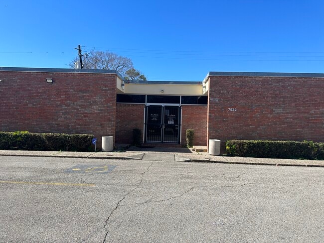
Property Record
7922 Hillcroft Ave, Houston, TX 77081

Current Lease Availabilities
Property Detail
7922 Hillcroft Ave
0882600000002
TR B4 MAPLEWOOD SEC 2
Medicalbuilding
HARRIS
C and X Area of minimal flood hazard, usually depicted on FIRMs as above the 500-year flood level.
Texas
2025
0.63 AC
2025
Southwest/Hillcroft
422602
Houston
8,400 SF
Houston-Pasadena-The Woodlands, TX
NEARBY LISTINGS FOR SALE OR LEASE
DEMOGRAPHICS near 7922 Hillcroft Ave
1 mile
3 mile
5 mile
2025 Total Population
24,630
234,999
596,647
2030 Population
26,150
251,361
638,116
Pop Growth 2025-2030
+ 6.17%
+ 6.96%
+ 6.95%
Average Age
37
36
37
2025 Total Households
8,383
87,595
247,347
HH Growth 2025-2030
+ 6.39%
+ 7.13%
+ 7.19%
Median Household Inc
$54,588
$53,825
$61,986
Avg Household Size
2.80
2.60
2.40
2025 Avg HH Vehicles
2.00
2.00
1.00
Median Home Value
$289,067
$365,767
$374,014
Median Year Built
1965
1975
1981
Nearby Places
Map Layers
Map Styles
 Street
 Aerial
Layers
 Traffic
 Biking
Places
Listings with unknown addresses are not visible on the map
- Restaurants
- Banks
- Shops
- Fitness
- Groceries
PUBLIC TRANSPORTATION
AIRPORT
William P Hobby
Drive
Walk
Distance
William P Hobby
34 min
20.0 mi
George Bush Intcntl/Houston
Drive
Walk
Distance
George Bush Intcntl/Houston
38 min
31.1 mi
Freight Ports
Port of Houston
Drive
Walk
Distance
Port of Houston
1 min
13.5 mi
Nearby Properties
Address
Land Use
TOTAL SIZE
Lot Size
Zoning
Address
Land Use
TOTAL SIZE
Lot Size
Zoning
777,791 SF
47.90 AC
Address
Land Use
TOTAL SIZE
Lot Size
Zoning
1,202,191 SF
39.08 AC
Address
Land Use
TOTAL SIZE
Lot Size
Zoning
1,612,349 SF
54.03 AC
Address
Land Use
TOTAL SIZE
Lot Size
Zoning
507,252 SF
5.93 AC
Address
Land Use
TOTAL SIZE
Lot Size
Zoning
417,988 SF
15.70 AC
Address
Land Use
TOTAL SIZE
Lot Size
Zoning
807,423 SF
30.01 AC
Address
Land Use
TOTAL SIZE
Lot Size
Zoning
812,087 SF
28.58 AC
Address
Land Use
TOTAL SIZE
Lot Size
Zoning
769,005 SF
20.46 AC
Address
Land Use
TOTAL SIZE
Lot Size
Zoning
544,698 SF
15.66 AC
Address
Land Use
TOTAL SIZE
Lot Size
Zoning
640,860 SF
5.31 AC
Address
Land Use
TOTAL SIZE
Lot Size
Zoning
398,772 SF
2.97 AC
Address
Land Use
TOTAL SIZE
Lot Size
Zoning
297,620 SF
11.01 AC
Address
Land Use
TOTAL SIZE
Lot Size
Zoning
290,624 SF
3.17 AC
Address
Land Use
TOTAL SIZE
Lot Size
Zoning
450,314 SF
10.81 AC
Address
Land Use
TOTAL SIZE
Lot Size
Zoning
493,494 SF
13.54 AC
Address
Land Use
TOTAL SIZE
Lot Size
Zoning
456,076 SF
19.09 AC
Address
Land Use
TOTAL SIZE
Lot Size
Zoning
481,176 SF
18.15 AC
Address
Land Use
TOTAL SIZE
Lot Size
Zoning
87,017 SF
3.19 AC
Address
Land Use
TOTAL SIZE
Lot Size
Zoning
543,903 SF
5.11 AC
Address
Land Use
TOTAL SIZE
Lot Size
Zoning
330,704 SF
10.18 AC
Address
Land Use
TOTAL SIZE
Lot Size
Zoning
414,014 SF
7.77 AC
Address
Land Use
TOTAL SIZE
Lot Size
Zoning
623,343 SF
22.89 AC
Address
Land Use
TOTAL SIZE
Lot Size
Zoning
287,776 SF
4.84 AC
Address
Land Use
TOTAL SIZE
Lot Size
Zoning
325,664 SF
14.16 AC
Address
Land Use
TOTAL SIZE
Lot Size
Zoning
248,671 SF
2.33 AC
Address
Land Use
TOTAL SIZE
Lot Size
Zoning
510,491 SF
15.31 AC
Address
Land Use
TOTAL SIZE
Lot Size
Zoning
434,744 SF
16.74 AC
Address
Land Use
TOTAL SIZE
Lot Size
Zoning
431,227 SF
15.51 AC
Address
Land Use
TOTAL SIZE
Lot Size
Zoning
396,594 SF
16.34 AC
Address
Land Use
TOTAL SIZE
Lot Size
Zoning
894,136 SF
12.51 AC
The World's #1 Commercial Real Estate Marketplace
Connect with us
© 2026 CoStar Group
The information above has been obtained from sources believed reliable. While we do not doubt its accuracy we have not verified it and make no guarantee, warranty or representation about it. It is your responsibility to independently confirm its accuracy and completeness. Any projections, opinions, assumptions, or estimates used are for example only and do not represent the current or future performance of the property. The value of this transaction to you depends on tax and other factors which should be evaluated by your tax, financial, and legal advisors. You and your advisors should conduct a careful, independent investigation of the property to determine to your satisfaction the suitability of the property for your needs.