Property Record
7933 Bustleton Ave, Philadelphia, PA 19152
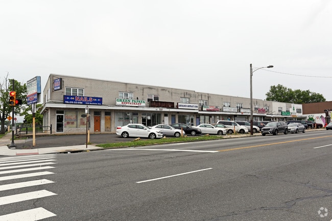
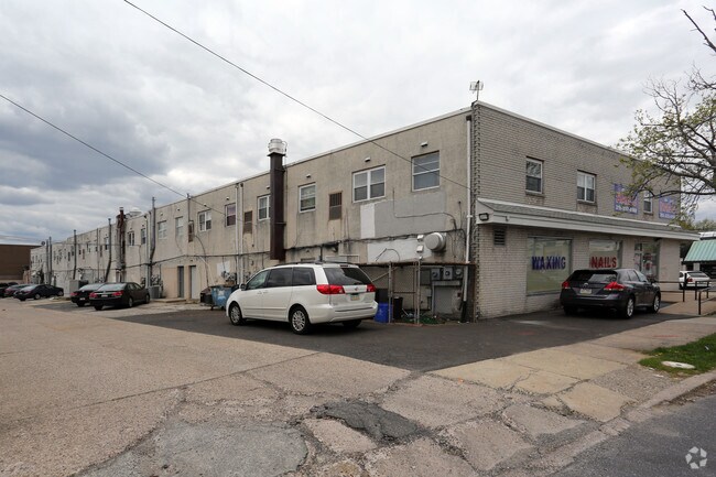
Property Detail
7933 Bustleton Ave
871245950
306 5/8 S LONEY ST
Commercialnec
Philadelphia
CMX1
Pennsylvania
B and X Area of moderate flood hazard, usually the area between the limits of the 100-year and 500-year floods.
287
2024
0.05 AC
2026
Northeast Philadelphia
033400
Philadelphia
2,090 SF
Philadelphia-Camden-Wilmington, PA-NJ-DE-MD
NEARBY LISTINGS FOR SALE OR LEASE
DEMOGRAPHICS near 7933 Bustleton Ave
1 mile
3 mile
5 mile
2025 Total Population
33,909
281,022
551,251
2030 Population
32,657
272,747
539,185
Pop Growth 2025-2030
(3.69%)
(2.94%)
(2.19%)
Average Age
41
39
40
2025 Total Households
12,374
102,205
203,708
HH Growth 2025-2030
(4.03%)
(3.09%)
(2.28%)
Median Household Inc
$57,098
$61,207
$63,578
Avg Household Size
2.60
2.70
2.60
2025 Avg HH Vehicles
1.00
1.00
1.00
Median Home Value
$274,456
$242,323
$249,246
Median Year Built
1958
1955
1955
Nearby Places
Map Layers
Map Styles
 Street
 Aerial
Layers
 Traffic
 Biking
Places
Listings with unknown addresses are not visible on the map
- Restaurants
- Banks
- Shops
- Fitness
- Groceries
PUBLIC TRANSPORTATION
COMMUTER RAIL
Fox Chase (R8 - Southeastern Pennsylvania Transportation Authority Regional Rail (SEPTA Regional Rail))
Drive
Walk
Distance
Fox Chase (R8 - Southeastern Pennsylvania Transportation Authority Regional Rail (SEPTA Regional Rail))
4 min
2.3 mi
Ryers (R8 - Southeastern Pennsylvania Transportation Authority Regional Rail (SEPTA Regional Rail))
Drive
Walk
Distance
Ryers (R8 - Southeastern Pennsylvania Transportation Authority Regional Rail (SEPTA Regional Rail))
5 min
2.7 mi
AIRPORT
Philadelphia International
Drive
Walk
Distance
Philadelphia International
35 min
20.8 mi
Trenton Mercer
Drive
Walk
Distance
Trenton Mercer
36 min
22.4 mi
Freight Ports
Port of Philadelphia
Drive
Walk
Distance
Port of Philadelphia
14 min
6.7 mi
SALE & LEASE HISTORY
LISTING DATE
SALE/LEASE

Sep 25, 2016
For Lease
May 25, 2017
For Lease
Nearby Properties
Address
Land Use
TOTAL SIZE
Lot Size
Zoning
Address
Land Use
TOTAL SIZE
Lot Size
Zoning
1,015,495 SF
70.51 AC
I1
Address
Land Use
TOTAL SIZE
Lot Size
Zoning
597,188 SF
120.50 AC
RM2
Address
Land Use
TOTAL SIZE
Lot Size
Zoning
234,945 SF
10.14 AC
CA1
Address
Land Use
TOTAL SIZE
Lot Size
Zoning
290,454 SF
58.56 AC
RSA1
Address
Land Use
TOTAL SIZE
Lot Size
Zoning
180,000 SF
23.05 AC
RSA1
Address
Land Use
TOTAL SIZE
Lot Size
Zoning
37.21 AC
SPPOA
Address
Land Use
TOTAL SIZE
Lot Size
Zoning
107,391 SF
13.68 AC
SPINS
Address
Land Use
TOTAL SIZE
Lot Size
Zoning
410,400 SF
34.14 AC
RSA1
Address
Land Use
TOTAL SIZE
Lot Size
Zoning
425,128 SF
23 AC
RSA5
Address
Land Use
TOTAL SIZE
Lot Size
Zoning
282,736 SF
21.32 AC
I1
Address
Land Use
TOTAL SIZE
Lot Size
Zoning
213,065 SF
16.12 AC
CA2
Address
Land Use
TOTAL SIZE
Lot Size
Zoning
264,852 SF
12.30 AC
CA2
Address
Land Use
TOTAL SIZE
Lot Size
Zoning
260,178 SF
20.87 AC
CA2
Address
Land Use
TOTAL SIZE
Lot Size
Zoning
314,694 SF
96.36 AC
RSA3
Address
Land Use
TOTAL SIZE
Lot Size
Zoning
2,500,000 SF
134.14 AC
I2
Address
Land Use
TOTAL SIZE
Lot Size
Zoning
1,316,590 SF
48.72 AC
I2
Address
Land Use
TOTAL SIZE
Lot Size
Zoning
325,000 SF
12.47 AC
RMX1
Address
Land Use
TOTAL SIZE
Lot Size
Zoning
526,165 SF
12.68 AC
RSA3
Address
Land Use
TOTAL SIZE
Lot Size
Zoning
28,239 SF
1.48 AC
SPINS
Address
Land Use
TOTAL SIZE
Lot Size
Zoning
251,791 SF
15.59 AC
I2
Address
Land Use
TOTAL SIZE
Lot Size
Zoning
16,832 SF
65.87 AC
SPPOA
Address
Land Use
TOTAL SIZE
Lot Size
Zoning
223,050 SF
12.31 AC
RSA5
Address
Land Use
TOTAL SIZE
Lot Size
Zoning
41.25 AC
RSA1
Address
Land Use
TOTAL SIZE
Lot Size
Zoning
403,010 SF
9 AC
SPINS
Address
Land Use
TOTAL SIZE
Lot Size
Zoning
228,652 SF
12.81 AC
I1
Address
Land Use
TOTAL SIZE
Lot Size
Zoning
5.37 AC
I2
Address
Land Use
TOTAL SIZE
Lot Size
Zoning
43.93 AC
RSD1
Address
Land Use
TOTAL SIZE
Lot Size
Zoning
184,500 SF
5.40 AC
RSD3
Address
Land Use
TOTAL SIZE
Lot Size
Zoning
283,262 SF
7.85 AC
RM2
Address
Land Use
TOTAL SIZE
Lot Size
Zoning
437,192 SF
28.03 AC
I2
The World's #1 Commercial Real Estate Marketplace
Connect with us
© 2026 CoStar Group
The information above has been obtained from sources believed reliable. While we do not doubt its accuracy we have not verified it and make no guarantee, warranty or representation about it. It is your responsibility to independently confirm its accuracy and completeness. Any projections, opinions, assumptions, or estimates used are for example only and do not represent the current or future performance of the property. The value of this transaction to you depends on tax and other factors which should be evaluated by your tax, financial, and legal advisors. You and your advisors should conduct a careful, independent investigation of the property to determine to your satisfaction the suitability of the property for your needs.