Property Record
7929 Liberty Rd, Windsor Mill, MD 21244
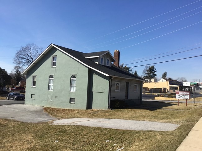

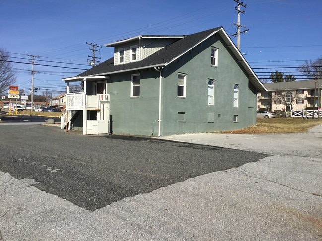

Property Detail
7929 Liberty Rd
02-0213400820
15,182 SQ FT SE COR ABBIE PL
Officebuilding
Baltimore
RO
Maryland
B and X Area of moderate flood hazard, usually the area between the limits of the 100-year and 500-year floods.
0.35 AC
2024
Woodlawn
2025
Baltimore
402303
Baltimore-Columbia-Towson, MD
1,710 SF
NEARBY LISTINGS FOR SALE OR LEASE
DEMOGRAPHICS near 7929 Liberty Rd
1 mile
3 mile
5 mile
2025 Total Population
18,440
108,934
280,004
2030 Population
18,368
108,559
278,326
Pop Growth 2025-2030
(0.39%)
(0.34%)
(0.60%)
Average Age
40
42
41
2025 Total Households
7,075
42,952
110,029
HH Growth 2025-2030
(0.40%)
(0.37%)
(0.67%)
Median Household Inc
$74,568
$73,673
$76,532
Avg Household Size
2.50
2.40
2.40
2025 Avg HH Vehicles
2.00
2.00
2.00
Median Home Value
$278,276
$285,949
$305,169
Median Year Built
1970
1968
1968
Nearby Places
Map Layers
Map Styles
 Street
 Aerial
Layers
 Traffic
 Biking
Places
Listings with unknown addresses are not visible on the map
- Restaurants
- Banks
- Shops
- Fitness
- Groceries
PUBLIC TRANSPORTATION
COMMUTER RAIL
Penn Station (Penn Line - Maryland Area Regional Commuter Trains (The MARC))
Drive
Walk
Distance
Penn Station (Penn Line - Maryland Area Regional Commuter Trains (The MARC))
23 min
8.5 mi
AIRPORT
Baltimore/Washington International Thurgood Marshall
Drive
Walk
Distance
Baltimore/Washington International Thurgood Marshall
23 min
14.2 mi
Ronald Reagan Washington Ntl
Drive
Walk
Distance
Ronald Reagan Washington Ntl
66 min
43.9 mi
Freight Ports
Port of Baltimore
Drive
Walk
Distance
Port of Baltimore
23 min
14.5 mi
SALE & LEASE HISTORY
LISTING DATE
SALE/LEASE

Sep 24, 2016
For Sale
May 02, 2018
For Sale
Nearby Properties
Address
Land Use
TOTAL SIZE
Lot Size
Zoning
Address
Land Use
TOTAL SIZE
Lot Size
Zoning
941,727 SF
36.89 AC
TOD-3
Address
Land Use
TOTAL SIZE
Lot Size
Zoning
883,140 SF
57.77 AC
MLR
Address
Land Use
TOTAL SIZE
Lot Size
Zoning
173,057 SF
17.22 AC
Address
Land Use
TOTAL SIZE
Lot Size
Zoning
278,271 SF
55.16 AC
DR5.5
Address
Land Use
TOTAL SIZE
Lot Size
Zoning
233,082 SF
10.98 AC
Address
Land Use
TOTAL SIZE
Lot Size
Zoning
29.11 AC
DR16
Address
Land Use
TOTAL SIZE
Lot Size
Zoning
27.75 AC
DR16
Address
Land Use
TOTAL SIZE
Lot Size
Zoning
184,320 SF
13.37 AC
DR5.5
Address
Land Use
TOTAL SIZE
Lot Size
Zoning
16.75 AC
MLR02
Address
Land Use
TOTAL SIZE
Lot Size
Zoning
325,203 SF
6.24 AC
DR5.5
Address
Land Use
TOTAL SIZE
Lot Size
Zoning
16.70 AC
Address
Land Use
TOTAL SIZE
Lot Size
Zoning
26.88 AC
DR16
Address
Land Use
TOTAL SIZE
Lot Size
Zoning
29.14 AC
DR16
Address
Land Use
TOTAL SIZE
Lot Size
Zoning
19.10 AC
DR16
Address
Land Use
TOTAL SIZE
Lot Size
Zoning
Address
Land Use
TOTAL SIZE
Lot Size
Zoning
14.41 AC
Address
Land Use
TOTAL SIZE
Lot Size
Zoning
7.05 AC
BM
Address
Land Use
TOTAL SIZE
Lot Size
Zoning
22.99 AC
DR16
Address
Land Use
TOTAL SIZE
Lot Size
Zoning
6.14 AC
02
Address
Land Use
TOTAL SIZE
Lot Size
Zoning
194,844 SF
14.33 AC
ML
Address
Land Use
TOTAL SIZE
Lot Size
Zoning
19.35 AC
DR16
Address
Land Use
TOTAL SIZE
Lot Size
Zoning
12.07 AC
DR16
Address
Land Use
TOTAL SIZE
Lot Size
Zoning
140,286 SF
11.71 AC
BR
Address
Land Use
TOTAL SIZE
Lot Size
Zoning
190,243 SF
3.28 AC
R-9
Address
Land Use
TOTAL SIZE
Lot Size
Zoning
13.68 AC
DR16
Address
Land Use
TOTAL SIZE
Lot Size
Zoning
8.76 AC
RAE1
Address
Land Use
TOTAL SIZE
Lot Size
Zoning
162,386 SF
30.68 AC
DR5.5
Address
Land Use
TOTAL SIZE
Lot Size
Zoning
116,645 SF
9.86 AC
Address
Land Use
TOTAL SIZE
Lot Size
Zoning
12.69 AC
DR16
Address
Land Use
TOTAL SIZE
Lot Size
Zoning
180,274 SF
46 AC
DR5.5
The World's #1 Commercial Real Estate Marketplace
Connect with us
© 2026 CoStar Group
The information above has been obtained from sources believed reliable. While we do not doubt its accuracy we have not verified it and make no guarantee, warranty or representation about it. It is your responsibility to independently confirm its accuracy and completeness. Any projections, opinions, assumptions, or estimates used are for example only and do not represent the current or future performance of the property. The value of this transaction to you depends on tax and other factors which should be evaluated by your tax, financial, and legal advisors. You and your advisors should conduct a careful, independent investigation of the property to determine to your satisfaction the suitability of the property for your needs.