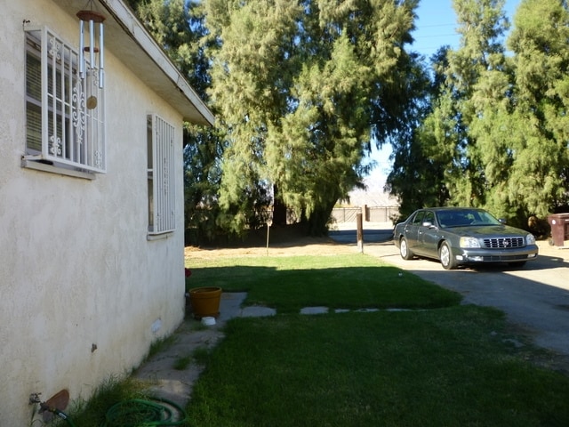
Property Record
79291 Avenue 40 Ave, Indio, CA 92203
NEARBY LISTINGS FOR SALE OR LEASE
Property Detail
79291 Avenue 40 Ave
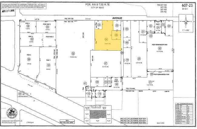
607-230-006
.53 ACRES IN POR NW 1/4 OF SEC 8 T5S R7E FOR TOTAL DESCRIPTION SEE ASSESSORS MAPS
Residentialacreage
Riverside
A
California
06065C1620G
0.53 AC
2024
Coachella Valley
2025
Inland Empire (California)
045216
Riverside-San Bernardino-Ontario, CA
DEMOGRAPHICS near 79291 Avenue 40 Ave
1 mile
3 mile
5 mile
2024 Total Population
6,573
63,913
149,186
2029 Population
7,061
69,235
160,999
Pop Growth 2024-2029
+ 7.42%
+ 8.33%
+ 7.92%
Average Age
48
49
45
2024 Total Households
2,834
27,269
57,627
HH Growth 2024-2029
+ 7.27%
+ 8.24%
+ 8.25%
Median Household Inc
$67,805
$78,083
$73,321
Avg Household Size
2.20
2.30
2.50
2024 Avg HH Vehicles
2.00
2.00
2.00
Median Home Value
$448,837
$497,728
$492,534
Median Year Built
1994
1997
1993
Nearby Places
Map Layers
Map Styles
 Street
 Aerial
Transit
 Traffic
 Biking
Places
Listings with unknown addresses are not visible on the map
- Restaurants
- Banks
- Shops
- Fitness
- Groceries
PUBLIC TRANSPORTATION
AIRPORT
Palm Springs International
Drive
Walk
Distance
Palm Springs International
24 min
16.6 mi
Freight Ports
Port of San Diego
Drive
Walk
Distance
Port of San Diego
169 min
140.8 mi
Nearby Properties
Address
Land Use
TOTAL SIZE
Lot Size
Zoning
Address
Land Use
TOTAL SIZE
Lot Size
Zoning
51.81 AC
Address
Land Use
TOTAL SIZE
Lot Size
Zoning
110,000 SF
39.46 AC
Address
Land Use
TOTAL SIZE
Lot Size
Zoning
160,365 SF
6.98 AC
PC2
Address
Land Use
TOTAL SIZE
Lot Size
Zoning
110,354 SF
14.15 AC
RH
Address
Land Use
TOTAL SIZE
Lot Size
Zoning
284,977 SF
23.95 AC
Address
Land Use
TOTAL SIZE
Lot Size
Zoning
92,591 SF
4.56 AC
Address
Land Use
TOTAL SIZE
Lot Size
Zoning
229,800 SF
3.89 AC
Address
Land Use
TOTAL SIZE
Lot Size
Zoning
123,134 SF
6.61 AC
RM
Address
Land Use
TOTAL SIZE
Lot Size
Zoning
139,456 SF
8.02 AC
R-3
Address
Land Use
TOTAL SIZE
Lot Size
Zoning
208,171 SF
16.83 AC
CBOOK
Address
Land Use
TOTAL SIZE
Lot Size
Zoning
96,384 SF
9.90 AC
SPZONE
Address
Land Use
TOTAL SIZE
Lot Size
Zoning
131,298 SF
10.06 AC
CPS
Address
Land Use
TOTAL SIZE
Lot Size
Zoning
83,753 SF
2.77 AC
RM
Address
Land Use
TOTAL SIZE
Lot Size
Zoning
158,234 SF
7.38 AC
IP
Address
Land Use
TOTAL SIZE
Lot Size
Zoning
70,397 SF
3.20 AC
M
Address
Land Use
TOTAL SIZE
Lot Size
Zoning
38,644 SF
18.57 AC
Address
Land Use
TOTAL SIZE
Lot Size
Zoning
53,250 SF
6.62 AC
Address
Land Use
TOTAL SIZE
Lot Size
Zoning
42,414 SF
1.43 AC
NC
Address
Land Use
TOTAL SIZE
Lot Size
Zoning
61 AC
A15
Address
Land Use
TOTAL SIZE
Lot Size
Zoning
106,160 SF
9.02 AC
MIX
Address
Land Use
TOTAL SIZE
Lot Size
Zoning
85,102 SF
61.12 AC
Address
Land Use
TOTAL SIZE
Lot Size
Zoning
59,416 SF
3.38 AC
W2
Address
Land Use
TOTAL SIZE
Lot Size
Zoning
16,588 SF
3.80 AC
R2A3500
Address
Land Use
TOTAL SIZE
Lot Size
Zoning
18,348 SF
5.92 AC
R3
Address
Land Use
TOTAL SIZE
Lot Size
Zoning
58,771 SF
3.41 AC
Address
Land Use
TOTAL SIZE
Lot Size
Zoning
67,857 SF
3.54 AC
IP
Address
Land Use
TOTAL SIZE
Lot Size
Zoning
99,491 SF
2.29 AC
W2
Address
Land Use
TOTAL SIZE
Lot Size
Zoning
35,324 SF
4.06 AC
Address
Land Use
TOTAL SIZE
Lot Size
Zoning
20,222 SF
9.18 AC
The World's #1 Commercial Real Estate Marketplace
Connect with us
© 2026 CoStar Group
The information above has been obtained from sources believed reliable. While we do not doubt its accuracy we have not verified it and make no guarantee, warranty or representation about it. It is your responsibility to independently confirm its accuracy and completeness. Any projections, opinions, assumptions, or estimates used are for example only and do not represent the current or future performance of the property. The value of this transaction to you depends on tax and other factors which should be evaluated by your tax, financial, and legal advisors. You and your advisors should conduct a careful, independent investigation of the property to determine to your satisfaction the suitability of the property for your needs.