Property Record
7930 Thaxton Rd, Austin, TX 78747


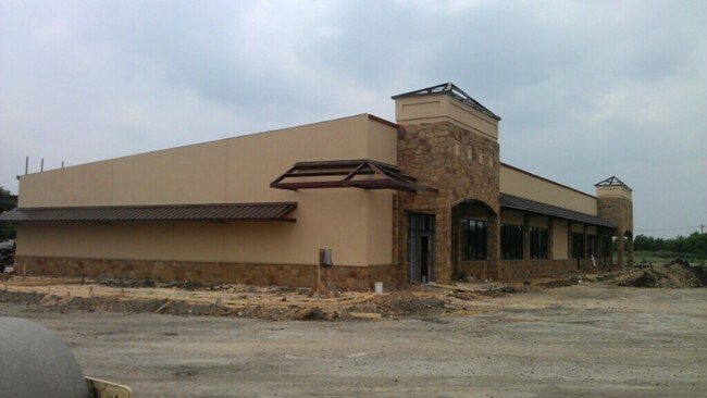
Property Detail
7930 Thaxton Rd
Austin-Round Rock-San Marcos, TX
Thaxton/Panadero
760241
LOT 1 BLK A THAXTON/PANADERO
Storebuilding
Travis
X
Texas
48453C0611K
1
2025
4.65 AC
2025
Southeast
002440
Austin
11,286 SF
NEARBY LISTINGS FOR SALE OR LEASE
DEMOGRAPHICS near 7930 Thaxton Rd
1 mile
3 mile
5 mile
2024 Total Population
10,708
69,944
166,649
2029 Population
11,729
76,104
181,312
Pop Growth 2024-2029
+ 9.53%
+ 8.81%
+ 8.80%
Average Age
35
35
36
2024 Total Households
3,453
25,202
66,411
HH Growth 2024-2029
+ 10.51%
+ 9.64%
+ 9.52%
Median Household Inc
$83,707
$68,702
$70,348
Avg Household Size
3.00
2.70
2.40
2024 Avg HH Vehicles
2.00
2.00
2.00
Median Home Value
$273,856
$283,677
$333,996
Median Year Built
2008
2005
2001
Nearby Places
Map Layers
Map Styles
 Street
 Aerial
Transit
 Traffic
 Biking
Places
Listings with unknown addresses are not visible on the map
- Restaurants
- Banks
- Shops
- Fitness
- Groceries
PUBLIC TRANSPORTATION
AIRPORT
Austin-Bergstrom International
Drive
Walk
Distance
Austin-Bergstrom International
21 min
8.8 mi
Nearby Properties
Address
Land Use
TOTAL SIZE
Lot Size
Zoning
Address
Land Use
TOTAL SIZE
Lot Size
Zoning
335,913 SF
13.83 AC
Address
Land Use
TOTAL SIZE
Lot Size
Zoning
380,191 SF
37.33 AC
Address
Land Use
TOTAL SIZE
Lot Size
Zoning
287,925 SF
9.92 AC
Address
Land Use
TOTAL SIZE
Lot Size
Zoning
314,325 SF
29.53 AC
Address
Land Use
TOTAL SIZE
Lot Size
Zoning
287,267 SF
13.28 AC
Address
Land Use
TOTAL SIZE
Lot Size
Zoning
414,030 SF
55.96 AC
Address
Land Use
TOTAL SIZE
Lot Size
Zoning
288,174 SF
18.91 AC
Address
Land Use
TOTAL SIZE
Lot Size
Zoning
434,872 SF
12.57 AC
Address
Land Use
TOTAL SIZE
Lot Size
Zoning
287,100 SF
13.20 AC
Address
Land Use
TOTAL SIZE
Lot Size
Zoning
384,254 SF
24.13 AC
Address
Land Use
TOTAL SIZE
Lot Size
Zoning
333,746 SF
53.90 AC
Address
Land Use
TOTAL SIZE
Lot Size
Zoning
249,600 SF
14.48 AC
Address
Land Use
TOTAL SIZE
Lot Size
Zoning
318,962 SF
31.88 AC
Address
Land Use
TOTAL SIZE
Lot Size
Zoning
239,376 SF
30.04 AC
Address
Land Use
TOTAL SIZE
Lot Size
Zoning
352,450 SF
20.88 AC
Address
Land Use
TOTAL SIZE
Lot Size
Zoning
292,257 SF
33.21 AC
Address
Land Use
TOTAL SIZE
Lot Size
Zoning
244,830 SF
27.43 AC
Address
Land Use
TOTAL SIZE
Lot Size
Zoning
351,255 SF
12.45 AC
Address
Land Use
TOTAL SIZE
Lot Size
Zoning
220,275 SF
6.67 AC
Address
Land Use
TOTAL SIZE
Lot Size
Zoning
246,800 SF
16.43 AC
Address
Land Use
TOTAL SIZE
Lot Size
Zoning
242,550 SF
13.02 AC
Address
Land Use
TOTAL SIZE
Lot Size
Zoning
237,600 SF
17.79 AC
Address
Land Use
TOTAL SIZE
Lot Size
Zoning
249,216 SF
20.19 AC
Address
Land Use
TOTAL SIZE
Lot Size
Zoning
272,824 SF
15.83 AC
Address
Land Use
TOTAL SIZE
Lot Size
Zoning
223,575 SF
13.52 AC
Address
Land Use
TOTAL SIZE
Lot Size
Zoning
267,300 SF
17.53 AC
Address
Land Use
TOTAL SIZE
Lot Size
Zoning
287,740 SF
14.87 AC
Address
Land Use
TOTAL SIZE
Lot Size
Zoning
323,659 SF
12.03 AC
Address
Land Use
TOTAL SIZE
Lot Size
Zoning
248,784 SF
10.55 AC
Address
Land Use
TOTAL SIZE
Lot Size
Zoning
4,111 SF
90.12 AC
The World's #1 Commercial Real Estate Marketplace
Connect with us
© 2026 CoStar Group
The information above has been obtained from sources believed reliable. While we do not doubt its accuracy we have not verified it and make no guarantee, warranty or representation about it. It is your responsibility to independently confirm its accuracy and completeness. Any projections, opinions, assumptions, or estimates used are for example only and do not represent the current or future performance of the property. The value of this transaction to you depends on tax and other factors which should be evaluated by your tax, financial, and legal advisors. You and your advisors should conduct a careful, independent investigation of the property to determine to your satisfaction the suitability of the property for your needs.