Property Record
7931 N State Line Ave, Texarkana, TX 75503
NEARBY LISTINGS FOR SALE OR LEASE
Property Detail
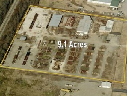
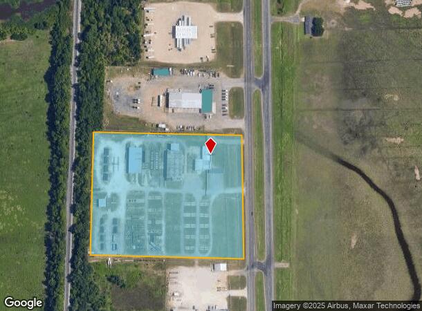
7931 N State Line Ave
25440000700
T & P Rr Co A-594
Industrialgeneral
T & P RR CO A-594 2023-9566 10/02/23 BLK/TRACT 9 9.14 ACRES
A
Bowie
48037C0225E
Texas
2024
9.14 AC
2025
Texas East Area
011201
Other Market Areas
27,228 SF
Texarkana, TX-AR
DEMOGRAPHICS near 7931 N State Line Ave
1 Mile
3 Mile
5 Mile
2024 Total Population
50
8,195
39,894
2029 Population
48
8,104
39,773
Pop Growth 2024-2029
(4.00%)
(1.11%)
(0.30%)
Average Age
43
42
40
2024 Total Households
18
3,342
16,584
HH Growth 2024-2029
(5.56%)
(1.11%)
(0.30%)
Median Household Inc
$187,499
$73,783
$53,253
Avg Household Size
2.60
2.40
2.30
2024 Avg HH Vehicles
2.00
2.00
2.00
Median Home Value
$366,666
$233,851
$163,532
Median Year Built
1986
1991
1981
Nearby Places
Map Layers
Map Styles
 Street
 Aerial
- Restaurants
- Banks
- Shops
- Fitness
- Groceries
PUBLIC TRANSPORTATION
COMMUTER RAIL
Texarkana Amtrak Station (Texas Eagle - Amtrak)
DRIVE
WALK
Distance
Texarkana Amtrak Station (Texas Eagle - Amtrak)
10 min
6.1 mi
AIRPORT
Texarkana Regional-Webb Field
DRIVE
WALK
Distance
Texarkana Regional-Webb Field
16 min
8.4 mi
Freight Ports
Port of Shreveport
DRIVE
WALK
Distance
Port of Shreveport
114 min
99.7 mi
Nearby Properties
Address
Land Use
TOTAL SIZE
Lot Size
Zoning
Address
Land Use
TOTAL SIZE
Lot Size
Zoning
11,320 SF
142 AC
Address
Land Use
TOTAL SIZE
Lot Size
Zoning
25,006 SF
3.93 AC
Address
Land Use
TOTAL SIZE
Lot Size
Zoning
42,117 SF
0.86 AC
Address
Land Use
TOTAL SIZE
Lot Size
Zoning
41,627 SF
6.12 AC
Address
Land Use
TOTAL SIZE
Lot Size
Zoning
50,355 SF
18.21 AC
Address
Land Use
TOTAL SIZE
Lot Size
Zoning
8,523 SF
12.90 AC
Address
Land Use
TOTAL SIZE
Lot Size
Zoning
47,110 SF
5.33 AC
Address
Land Use
TOTAL SIZE
Lot Size
Zoning
128,150 SF
11.57 AC
Address
Land Use
TOTAL SIZE
Lot Size
Zoning
31,168 SF
2 AC
Address
Land Use
TOTAL SIZE
Lot Size
Zoning
51,928 SF
4.01 AC
Address
Land Use
TOTAL SIZE
Lot Size
Zoning
37,930 SF
10.45 AC
Address
Land Use
TOTAL SIZE
Lot Size
Zoning
12,742 SF
2.18 AC
Address
Land Use
TOTAL SIZE
Lot Size
Zoning
17,327 SF
3.34 AC
Address
Land Use
TOTAL SIZE
Lot Size
Zoning
42,724 SF
3.18 AC
Address
Land Use
TOTAL SIZE
Lot Size
Zoning
94,554 SF
4.08 AC
Address
Land Use
TOTAL SIZE
Lot Size
Zoning
150,522 SF
38.85 AC
Address
Land Use
TOTAL SIZE
Lot Size
Zoning
101,440 SF
4 AC
Address
Land Use
TOTAL SIZE
Lot Size
Zoning
9,700 SF
1.69 AC
Address
Land Use
TOTAL SIZE
Lot Size
Zoning
67,944 SF
13.78 AC
Address
Land Use
TOTAL SIZE
Lot Size
Zoning
15,087 SF
1.31 AC
Address
Land Use
TOTAL SIZE
Lot Size
Zoning
14,973 SF
2.09 AC
Address
Land Use
TOTAL SIZE
Lot Size
Zoning
22,000 SF
2.50 AC
Address
Land Use
TOTAL SIZE
Lot Size
Zoning
19,574 SF
2.60 AC
Address
Land Use
TOTAL SIZE
Lot Size
Zoning
16,851 SF
2.31 AC
Address
Land Use
TOTAL SIZE
Lot Size
Zoning
24,000 SF
3.57 AC
Address
Land Use
TOTAL SIZE
Lot Size
Zoning
11,625 SF
8.75 AC
Address
Land Use
TOTAL SIZE
Lot Size
Zoning
8,075 SF
8.75 AC
Address
Land Use
TOTAL SIZE
Lot Size
Zoning
96,550 SF
3.38 AC
Address
Land Use
TOTAL SIZE
Lot Size
Zoning
26,755 SF
3.59 AC
Address
Land Use
TOTAL SIZE
Lot Size
Zoning
28,014 SF
5.33 AC
The World's #1 Commercial Real Estate Marketplace
Connect with us
© 2025 CoStar Group
The information above has been obtained from sources believed reliable. While we do not doubt its accuracy we have not verified it and make no guarantee, warranty or representation about it. It is your responsibility to independently confirm its accuracy and completeness. Any projections, opinions, assumptions, or estimates used are for example only and do not represent the current or future performance of the property. The value of this transaction to you depends on tax and other factors which should be evaluated by your tax, financial, and legal advisors. You and your advisors should conduct a careful, independent investigation of the property to determine to your satisfaction the suitability of the property for your needs.