Property Record
7933 Watt Ave, Antelope, CA 95843


Save to a Folder
{{folder.Name}}
{{folder.ListingIds.length}} Properties
{{folder.ListingIds.length}} Property
Create a New Folder
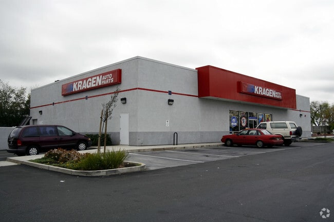
This Property Is For Sale
Property Detail
7933 Watt Ave
203-2070-001
PARCEL MAP, LOT 1
Storebuilding
Sacramento
SC
California
B and X Area of moderate flood hazard, usually the area between the limits of the 100-year and 500-year floods.
1
2025
0.99 AC
2026
Rio Linda/N Highlands
007417
Sacramento
7,009 SF
Sacramento-Roseville-Folsom, CA
NEARBY LISTINGS FOR SALE OR LEASE
DEMOGRAPHICS near 7933 Watt Ave
1 mile
3 mile
5 mile
2025 Total Population
14,432
91,713
228,931
2030 Population
14,567
93,070
233,497
Pop Growth 2025-2030
+ 0.94%
+ 1.48%
+ 1.99%
Average Age
38
38
39
2025 Total Households
4,521
28,686
77,613
HH Growth 2025-2030
+ 0.93%
+ 1.53%
+ 2.08%
Median Household Inc
$94,149
$91,110
$85,765
Avg Household Size
3.20
3.10
2.90
2025 Avg HH Vehicles
2.00
2.00
2.00
Median Home Value
$468,980
$462,077
$474,043
Median Year Built
1984
1985
1983
Nearby Places
Map Layers
Map Styles
 Street
 Aerial
Layers
 Traffic
 Biking
Places
Listings with unknown addresses are not visible on the map
- Restaurants
- Banks
- Shops
- Fitness
- Groceries
PUBLIC TRANSPORTATION
COMMUTER RAIL
Roseville Amtrak (California Zephyr - Amtrak, Capitol Corridor - Amtrak)
Drive
Walk
Distance
Roseville Amtrak (California Zephyr - Amtrak, Capitol Corridor - Amtrak)
14 min
7.5 mi
AIRPORT
Sacramento International
Drive
Walk
Distance
Sacramento International
26 min
15.8 mi
Freight Ports
Port of Stockton
Drive
Walk
Distance
Port of Stockton
75 min
60.7 mi
Nearby Properties
Address
Land Use
TOTAL SIZE
Lot Size
Zoning
Address
Land Use
TOTAL SIZE
Lot Size
Zoning
173,174 SF
8.89 AC
RD-30
Address
Land Use
TOTAL SIZE
Lot Size
Zoning
183,000 SF
12.49 AC
RD-20
Address
Land Use
TOTAL SIZE
Lot Size
Zoning
14.88 AC
RD-20
Address
Land Use
TOTAL SIZE
Lot Size
Zoning
217,380 SF
10 AC
SPA
Address
Land Use
TOTAL SIZE
Lot Size
Zoning
200,104 SF
13.85 AC
RD-20
Address
Land Use
TOTAL SIZE
Lot Size
Zoning
146,283 SF
8.73 AC
RD-20
Address
Land Use
TOTAL SIZE
Lot Size
Zoning
244,048 SF
13.38 AC
RD-30
Address
Land Use
TOTAL SIZE
Lot Size
Zoning
16.08 AC
Address
Land Use
TOTAL SIZE
Lot Size
Zoning
160,497 SF
6.85 AC
RD-30
Address
Land Use
TOTAL SIZE
Lot Size
Zoning
280,864 SF
14.94 AC
RD-20
Address
Land Use
TOTAL SIZE
Lot Size
Zoning
141,274 SF
7.06 AC
RD-20
Address
Land Use
TOTAL SIZE
Lot Size
Zoning
185,342 SF
11.13 AC
RD-20
Address
Land Use
TOTAL SIZE
Lot Size
Zoning
81,124 SF
4.81 AC
RD-20
Address
Land Use
TOTAL SIZE
Lot Size
Zoning
0.13 AC
RD-7
Address
Land Use
TOTAL SIZE
Lot Size
Zoning
29.68 AC
Address
Land Use
TOTAL SIZE
Lot Size
Zoning
124,819 SF
13.10 AC
SC
Address
Land Use
TOTAL SIZE
Lot Size
Zoning
25.88 AC
Address
Land Use
TOTAL SIZE
Lot Size
Zoning
106,370 SF
5.91 AC
RD-30
Address
Land Use
TOTAL SIZE
Lot Size
Zoning
Address
Land Use
TOTAL SIZE
Lot Size
Zoning
91,526 SF
7.45 AC
SC
Address
Land Use
TOTAL SIZE
Lot Size
Zoning
149,950 SF
10.50 AC
RD-20
Address
Land Use
TOTAL SIZE
Lot Size
Zoning
40 AC
RD-7 O
Address
Land Use
TOTAL SIZE
Lot Size
Zoning
53.76 AC
RD-5
Address
Land Use
TOTAL SIZE
Lot Size
Zoning
83,504 SF
5.07 AC
SPA
Address
Land Use
TOTAL SIZE
Lot Size
Zoning
1,000 SF
0.32 AC
RMDL8DC
Address
Land Use
TOTAL SIZE
Lot Size
Zoning
168,810 SF
9.80 AC
RD-20
Address
Land Use
TOTAL SIZE
Lot Size
Zoning
95,788 SF
8.66 AC
SC
Address
Land Use
TOTAL SIZE
Lot Size
Zoning
51,460 SF
2.38 AC
SPA
Address
Land Use
TOTAL SIZE
Lot Size
Zoning
36.89 AC
RD-5
Address
Land Use
TOTAL SIZE
Lot Size
Zoning
86,400 SF
7.17 AC
GC
The World's #1 Commercial Real Estate Marketplace
Connect with us
© 2026 CoStar Group
The information above has been obtained from sources believed reliable. While we do not doubt its accuracy we have not verified it and make no guarantee, warranty or representation about it. It is your responsibility to independently confirm its accuracy and completeness. Any projections, opinions, assumptions, or estimates used are for example only and do not represent the current or future performance of the property. The value of this transaction to you depends on tax and other factors which should be evaluated by your tax, financial, and legal advisors. You and your advisors should conduct a careful, independent investigation of the property to determine to your satisfaction the suitability of the property for your needs.