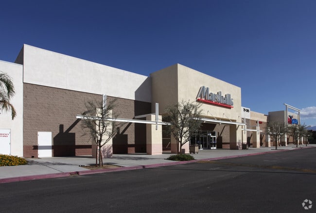
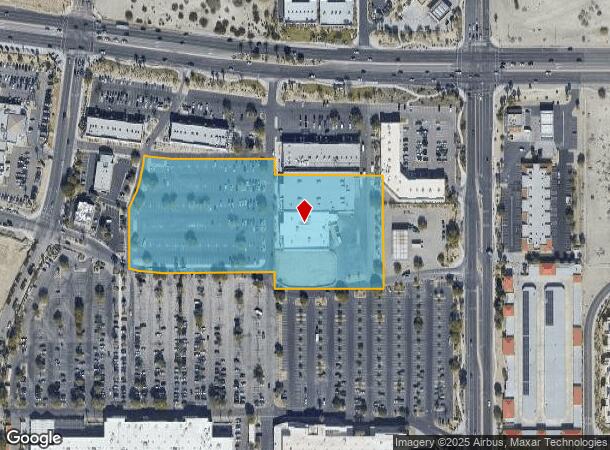
Property Record
79395 Highway 111, La Quinta, CA 92253


NEARBY LISTINGS FOR SALE OR LEASE
Property Detail
79395 Highway 111
Riverside-San Bernardino-Ontario, CA
Parcel Map No 30420
600-340-024
7.02 ACRES IN POR PAR 5 PM 202/040 PM 30420
Storebuilding
Riverside
X
California
06065C2234G
5
2024
7.02 AC
2025
Coachella Valley
045129
Inland Empire (California)
49,599 SF
DEMOGRAPHICS near 79395 Highway 111
1 Mile
3 Mile
5 Mile
2024 Total Population
8,790
83,689
186,458
2029 Population
9,440
90,026
201,461
Pop Growth 2024-2029
+ 7.39%
+ 7.57%
+ 8.05%
Average Age
43
43
44
2024 Total Households
3,391
31,464
69,870
HH Growth 2024-2029
+ 7.64%
+ 7.79%
+ 8.51%
Median Household Inc
$66,051
$71,087
$72,550
Avg Household Size
2.50
2.60
2.60
2024 Avg HH Vehicles
2.00
2.00
2.00
Median Home Value
$537,602
$527,195
$497,806
Median Year Built
2000
1993
1994
Nearby Places
Map Layers
Map Styles
 Street
 Aerial
- Restaurants
- Banks
- Shops
- Fitness
- Groceries
PUBLIC TRANSPORTATION
AIRPORT
Palm Springs International
DRIVE
WALK
Distance
Palm Springs International
29 min
20.0 mi
Freight Ports
Port of San Diego
DRIVE
WALK
Distance
Port of San Diego
174 min
129.2 mi
SALE & LEASE HISTORY
LISTING DATE
SALE/LEASE

May 30, 2024
For Lease
Apr 18, 2023
For Sale
Nearby Properties
Address
Land Use
TOTAL SIZE
Lot Size
Zoning
Address
Land Use
TOTAL SIZE
Lot Size
Zoning
260,171 SF
39.83 AC
R3
Address
Land Use
TOTAL SIZE
Lot Size
Zoning
51.81 AC
Address
Land Use
TOTAL SIZE
Lot Size
Zoning
42,225 SF
20.83 AC
HW
Address
Land Use
TOTAL SIZE
Lot Size
Zoning
21,992 SF
16.71 AC
Address
Land Use
TOTAL SIZE
Lot Size
Zoning
110,000 SF
39.46 AC
Address
Land Use
TOTAL SIZE
Lot Size
Zoning
162,192 SF
15.42 AC
Address
Land Use
TOTAL SIZE
Lot Size
Zoning
110,354 SF
14.15 AC
RH
Address
Land Use
TOTAL SIZE
Lot Size
Zoning
73,832 SF
7.71 AC
Address
Land Use
TOTAL SIZE
Lot Size
Zoning
233,006 SF
19.12 AC
Address
Land Use
TOTAL SIZE
Lot Size
Zoning
92,591 SF
4.56 AC
Address
Land Use
TOTAL SIZE
Lot Size
Zoning
229,800 SF
3.89 AC
Address
Land Use
TOTAL SIZE
Lot Size
Zoning
13.85 AC
Address
Land Use
TOTAL SIZE
Lot Size
Zoning
182,439 SF
10.76 AC
A110
Address
Land Use
TOTAL SIZE
Lot Size
Zoning
123,134 SF
6.61 AC
RM
Address
Land Use
TOTAL SIZE
Lot Size
Zoning
139,456 SF
8.02 AC
R-3
Address
Land Use
TOTAL SIZE
Lot Size
Zoning
189,101 SF
8.98 AC
C1
Address
Land Use
TOTAL SIZE
Lot Size
Zoning
55,072 SF
6.88 AC
C2
Address
Land Use
TOTAL SIZE
Lot Size
Zoning
170,272 SF
16.28 AC
Address
Land Use
TOTAL SIZE
Lot Size
Zoning
171,910 SF
14.89 AC
C1
Address
Land Use
TOTAL SIZE
Lot Size
Zoning
42,000 SF
3.20 AC
CR
Address
Land Use
TOTAL SIZE
Lot Size
Zoning
250,835 SF
10.27 AC
VC
Address
Land Use
TOTAL SIZE
Lot Size
Zoning
144,647 SF
16.60 AC
Address
Land Use
TOTAL SIZE
Lot Size
Zoning
153,418 SF
6.81 AC
Address
Land Use
TOTAL SIZE
Lot Size
Zoning
131,298 SF
10.06 AC
CPS
Address
Land Use
TOTAL SIZE
Lot Size
Zoning
83,753 SF
2.77 AC
RM
Address
Land Use
TOTAL SIZE
Lot Size
Zoning
55,695 SF
10.60 AC
C1
Address
Land Use
TOTAL SIZE
Lot Size
Zoning
81,004 SF
2.99 AC
Address
Land Use
TOTAL SIZE
Lot Size
Zoning
99,301 SF
Address
Land Use
TOTAL SIZE
Lot Size
Zoning
47,305 SF
7.24 AC
RC
Address
Land Use
TOTAL SIZE
Lot Size
Zoning
52,971 SF
7.29 AC
The World's #1 Commercial Real Estate Marketplace
Connect with us
© 2026 CoStar Group
The information above has been obtained from sources believed reliable. While we do not doubt its accuracy we have not verified it and make no guarantee, warranty or representation about it. It is your responsibility to independently confirm its accuracy and completeness. Any projections, opinions, assumptions, or estimates used are for example only and do not represent the current or future performance of the property. The value of this transaction to you depends on tax and other factors which should be evaluated by your tax, financial, and legal advisors. You and your advisors should conduct a careful, independent investigation of the property to determine to your satisfaction the suitability of the property for your needs.