Property Record
794 Normandy St, Houston, TX 77015
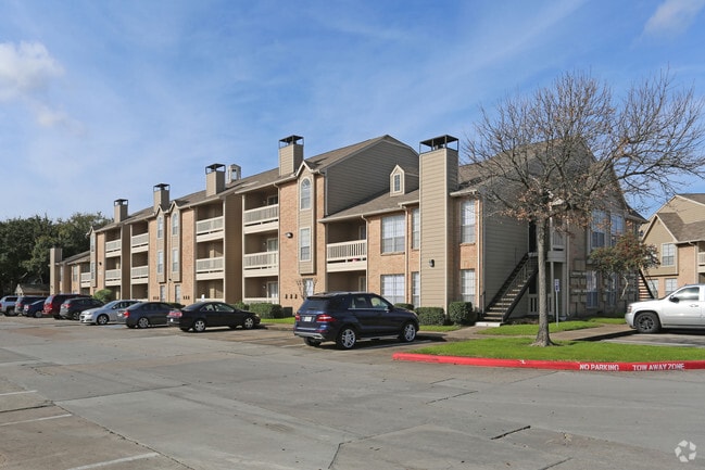


Property Detail
794 Normandy St
0402670020087
TR 16A ABST 33 S C HIROMS
Apartment
HARRIS
B and X Area of moderate flood hazard, usually the area between the limits of the 100-year and 500-year floods.
Texas
2024
10.06 AC
2025
Riviera East
232802
Houston
235,624 SF
Houston-Pasadena-The Woodlands, TX
NEARBY LISTINGS FOR SALE OR LEASE
DEMOGRAPHICS near 794 Normandy St
1 mile
3 mile
5 mile
2025 Total Population
18,258
96,037
184,322
2030 Population
19,544
102,223
196,557
Pop Growth 2025-2030
+ 7.04%
+ 6.44%
+ 6.64%
Average Age
35
35
35
2025 Total Households
6,286
30,127
56,888
HH Growth 2025-2030
+ 7.33%
+ 6.65%
+ 6.84%
Median Household Inc
$54,383
$56,666
$59,040
Avg Household Size
2.80
3.10
3.20
2025 Avg HH Vehicles
2.00
2.00
2.00
Median Home Value
$175,261
$175,808
$187,944
Median Year Built
1983
1978
1981
Nearby Places
Map Layers
Map Styles
 Street
 Aerial
Layers
 Traffic
 Biking
Places
Listings with unknown addresses are not visible on the map
- Restaurants
- Banks
- Shops
- Fitness
- Groceries
PUBLIC TRANSPORTATION
AIRPORT
William P Hobby
Drive
Walk
Distance
William P Hobby
29 min
16.2 mi
George Bush Intcntl/Houston
Drive
Walk
Distance
George Bush Intcntl/Houston
33 min
25.0 mi
Freight Ports
Port of Houston
Drive
Walk
Distance
Port of Houston
16 min
8.1 mi
Nearby Properties
Address
Land Use
TOTAL SIZE
Lot Size
Zoning
Address
Land Use
TOTAL SIZE
Lot Size
Zoning
13,460,439 SF
191.66 AC
Address
Land Use
TOTAL SIZE
Lot Size
Zoning
873,718 SF
49.59 AC
Address
Land Use
TOTAL SIZE
Lot Size
Zoning
337,331 SF
56.09 AC
Address
Land Use
TOTAL SIZE
Lot Size
Zoning
671,363 SF
61.27 AC
Address
Land Use
TOTAL SIZE
Lot Size
Zoning
2,124,914 SF
243.08 AC
Address
Land Use
TOTAL SIZE
Lot Size
Zoning
520,866 SF
23.25 AC
Address
Land Use
TOTAL SIZE
Lot Size
Zoning
422,526 SF
27.45 AC
Address
Land Use
TOTAL SIZE
Lot Size
Zoning
351,250 SF
23.84 AC
Address
Land Use
TOTAL SIZE
Lot Size
Zoning
450,084 SF
15.13 AC
Address
Land Use
TOTAL SIZE
Lot Size
Zoning
840,000 SF
200.29 AC
Address
Land Use
TOTAL SIZE
Lot Size
Zoning
202,544 SF
4.06 AC
Address
Land Use
TOTAL SIZE
Lot Size
Zoning
187,726 SF
32.24 AC
Address
Land Use
TOTAL SIZE
Lot Size
Zoning
343,265 SF
41.52 AC
Address
Land Use
TOTAL SIZE
Lot Size
Zoning
526,975 SF
21.08 AC
Address
Land Use
TOTAL SIZE
Lot Size
Zoning
889,587 SF
137.68 AC
Address
Land Use
TOTAL SIZE
Lot Size
Zoning
227,679 SF
13.31 AC
Address
Land Use
TOTAL SIZE
Lot Size
Zoning
49,384 SF
69.01 AC
Address
Land Use
TOTAL SIZE
Lot Size
Zoning
200.06 AC
Address
Land Use
TOTAL SIZE
Lot Size
Zoning
110,900 SF
18.01 AC
Address
Land Use
TOTAL SIZE
Lot Size
Zoning
208,648 SF
8.99 AC
Address
Land Use
TOTAL SIZE
Lot Size
Zoning
377,109 SF
17.36 AC
Address
Land Use
TOTAL SIZE
Lot Size
Zoning
246,277 SF
10.91 AC
Address
Land Use
TOTAL SIZE
Lot Size
Zoning
126.46 AC
Address
Land Use
TOTAL SIZE
Lot Size
Zoning
451,243 SF
20.10 AC
Address
Land Use
TOTAL SIZE
Lot Size
Zoning
141,017 SF
11.90 AC
Address
Land Use
TOTAL SIZE
Lot Size
Zoning
245,916 SF
12.24 AC
Address
Land Use
TOTAL SIZE
Lot Size
Zoning
532,658 SF
36.31 AC
Address
Land Use
TOTAL SIZE
Lot Size
Zoning
90,413 SF
8.42 AC
Address
Land Use
TOTAL SIZE
Lot Size
Zoning
198,265 SF
9.59 AC
The World's #1 Commercial Real Estate Marketplace
Connect with us
© 2026 CoStar Group
The information above has been obtained from sources believed reliable. While we do not doubt its accuracy we have not verified it and make no guarantee, warranty or representation about it. It is your responsibility to independently confirm its accuracy and completeness. Any projections, opinions, assumptions, or estimates used are for example only and do not represent the current or future performance of the property. The value of this transaction to you depends on tax and other factors which should be evaluated by your tax, financial, and legal advisors. You and your advisors should conduct a careful, independent investigation of the property to determine to your satisfaction the suitability of the property for your needs.