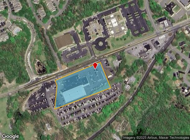
Property Record
794 Route 52, Fishkill, NY 12524
NEARBY LISTINGS FOR SALE OR LEASE
Property Detail
794 Route 52
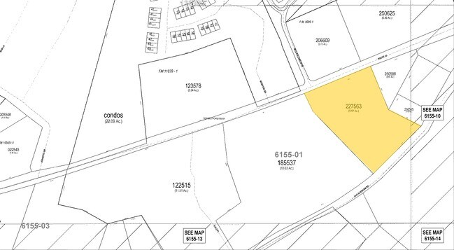
133089-6155-01-227563-0000
4.39 AC (D) 1929 0382 1730 0524
Vehiclerentalsvehiclesales
Dutchess
X
New York
36027C0468E
227
2025
2.96 AC
2024
Fishkill
060202
Westchester/So Connecticut
11,236 SF
Dutchess County-Putnam County, NY
DEMOGRAPHICS near 794 Route 52
1 Mile
3 Mile
5 Mile
2024 Total Population
4,264
32,244
72,107
2029 Population
4,233
32,236
72,391
Pop Growth 2024-2029
(0.73%)
(0.02%)
+ 0.39%
Average Age
46
43
42
2024 Total Households
1,931
13,251
28,879
HH Growth 2024-2029
(0.83%)
(0.11%)
+ 0.32%
Median Household Inc
$74,999
$90,320
$85,666
Avg Household Size
2.20
2.20
2.30
2024 Avg HH Vehicles
2.00
2.00
2.00
Median Home Value
$348,979
$384,523
$373,637
Median Year Built
1977
1975
1971
Nearby Places
Map Layers
Map Styles
 Street
 Aerial
- Restaurants
- Banks
- Shops
- Fitness
- Groceries
PUBLIC TRANSPORTATION
COMMUTER RAIL
Beacon Station (Hudson Line - Metro-North Commuter Railroad Company (Metro-North))
DRIVE
WALK
Distance
Beacon Station (Hudson Line - Metro-North Commuter Railroad Company (Metro-North))
9 min
4.1 mi
New Hamburg Station (Hudson Line - Metro-North Commuter Railroad Company (Metro-North))
DRIVE
WALK
Distance
New Hamburg Station (Hudson Line - Metro-North Commuter Railroad Company (Metro-North))
12 min
7.0 mi
AIRPORT
New York Stewart International
DRIVE
WALK
Distance
New York Stewart International
22 min
13.5 mi
Freight Ports
Port of New Haven
DRIVE
WALK
Distance
Port of New Haven
93 min
68.7 mi
Nearby Properties
Address
Land Use
TOTAL SIZE
Lot Size
Zoning
Address
Land Use
TOTAL SIZE
Lot Size
Zoning
1,240,333 SF
120.58 AC
PI
Address
Land Use
TOTAL SIZE
Lot Size
Zoning
137,278 SF
41.20 AC
R-50
Address
Land Use
TOTAL SIZE
Lot Size
Zoning
251,689 SF
43.70 AC
RMF5
Address
Land Use
TOTAL SIZE
Lot Size
Zoning
48,135 SF
40.98 AC
RMF5
Address
Land Use
TOTAL SIZE
Lot Size
Zoning
101,170 SF
28.71 AC
RMF5
Address
Land Use
TOTAL SIZE
Lot Size
Zoning
17.59 AC
R1-40
Address
Land Use
TOTAL SIZE
Lot Size
Zoning
773,000 SF
6.80 AC
PI
Address
Land Use
TOTAL SIZE
Lot Size
Zoning
293,984 SF
47.95 AC
RMF5
Address
Land Use
TOTAL SIZE
Lot Size
Zoning
94,340 SF
31.64 AC
RMF5
Address
Land Use
TOTAL SIZE
Lot Size
Zoning
47,187 SF
33 AC
R40
Address
Land Use
TOTAL SIZE
Lot Size
Zoning
36.65 AC
R1-20
Address
Land Use
TOTAL SIZE
Lot Size
Zoning
21,996 SF
17.36 AC
RMF5
Address
Land Use
TOTAL SIZE
Lot Size
Zoning
56,704 SF
5.03 AC
PSC
Address
Land Use
TOTAL SIZE
Lot Size
Zoning
123,536 SF
18.10 AC
GB
Address
Land Use
TOTAL SIZE
Lot Size
Zoning
118,800 SF
8.46 AC
PI
Address
Land Use
TOTAL SIZE
Lot Size
Zoning
248,686 SF
0.01 AC
PSC
Address
Land Use
TOTAL SIZE
Lot Size
Zoning
206,064 SF
31.72 AC
PI
Address
Land Use
TOTAL SIZE
Lot Size
Zoning
6.30 AC
PSC
Address
Land Use
TOTAL SIZE
Lot Size
Zoning
38,962 SF
16.80 AC
RMF5
Address
Land Use
TOTAL SIZE
Lot Size
Zoning
99,569 SF
16.10 AC
PSC
Address
Land Use
TOTAL SIZE
Lot Size
Zoning
105,500 SF
8.50 AC
RB
Address
Land Use
TOTAL SIZE
Lot Size
Zoning
11.86 AC
Address
Land Use
TOTAL SIZE
Lot Size
Zoning
466.77 AC
R40
Address
Land Use
TOTAL SIZE
Lot Size
Zoning
72,222 SF
7.62 AC
PSC
Address
Land Use
TOTAL SIZE
Lot Size
Zoning
12 AC
R1-10
Address
Land Use
TOTAL SIZE
Lot Size
Zoning
27,472 SF
0.67 AC
LI
Address
Land Use
TOTAL SIZE
Lot Size
Zoning
32,347 SF
17.10 AC
R20
Address
Land Use
TOTAL SIZE
Lot Size
Zoning
133,362 SF
18.85 AC
PSC
Address
Land Use
TOTAL SIZE
Lot Size
Zoning
38,699 SF
3.09 AC
GB
Address
Land Use
TOTAL SIZE
Lot Size
Zoning
117,740 SF
6.34 AC
PSC
The World's #1 Commercial Real Estate Marketplace
Connect with us
© 2025 CoStar Group
The information above has been obtained from sources believed reliable. While we do not doubt its accuracy we have not verified it and make no guarantee, warranty or representation about it. It is your responsibility to independently confirm its accuracy and completeness. Any projections, opinions, assumptions, or estimates used are for example only and do not represent the current or future performance of the property. The value of this transaction to you depends on tax and other factors which should be evaluated by your tax, financial, and legal advisors. You and your advisors should conduct a careful, independent investigation of the property to determine to your satisfaction the suitability of the property for your needs.