Property Record
7940 Nw 39Th Expy, Bethany, OK 73008


Save to a Folder
{{folder.Name}}
{{folder.ListingIds.length}} Properties
{{folder.ListingIds.length}} Property
Create a New Folder
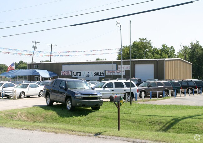
Property Detail
7940 Nw 39Th Expy
Oklahoma City, OK
SCHAFERS SUBURBS ADD 016 000 BEG 130.6FT E & 28.5FT S OF NW/C LOT 16 TH S279.48FT E165.10FT N280.25FT W165.10FT TO BEG
177363905
OKLAHOMA
Lightindustrial
Oklahoma
B and X Area of moderate flood hazard, usually the area between the limits of the 100-year and 500-year floods.
16
2024
0.89 AC
2025
West/Central
106704
Oklahoma City
5,900 SF
NEARBY LISTINGS FOR SALE OR LEASE
DEMOGRAPHICS near 7940 Nw 39Th Expy
1 mile
3 mile
5 mile
2025 Total Population
4,440
78,691
186,418
2030 Population
4,517
81,889
195,082
Pop Growth 2025-2030
+ 1.73%
+ 4.06%
+ 4.65%
Average Age
41
37
38
2025 Total Households
1,777
30,711
74,525
HH Growth 2025-2030
+ 1.86%
+ 4.10%
+ 4.38%
Median Household Inc
$68,207
$54,222
$62,435
Avg Household Size
2.30
2.50
2.40
2025 Avg HH Vehicles
2.00
2.00
2.00
Median Home Value
$253,773
$207,402
$215,828
Median Year Built
1968
1972
1974
Nearby Places
Map Layers
Map Styles
 Street
 Aerial
Layers
 Traffic
 Biking
Places
Listings with unknown addresses are not visible on the map
- Restaurants
- Banks
- Shops
- Fitness
- Groceries
PUBLIC TRANSPORTATION
AIRPORT
Will Rogers World
Drive
Walk
Distance
Will Rogers World
24 min
12.0 mi
Freight Ports
Tulsa Port Of Catoosa
Drive
Walk
Distance
Tulsa Port Of Catoosa
139 min
128.0 mi
Nearby Properties
Address
Land Use
TOTAL SIZE
Lot Size
Zoning
Address
Land Use
TOTAL SIZE
Lot Size
Zoning
334,227 SF
18.01 AC
Address
Land Use
TOTAL SIZE
Lot Size
Zoning
44,519 SF
3.39 AC
SPUD
Address
Land Use
TOTAL SIZE
Lot Size
Zoning
37,400 SF
4.23 AC
PUD
Address
Land Use
TOTAL SIZE
Lot Size
Zoning
144,735 SF
28 AC
Address
Land Use
TOTAL SIZE
Lot Size
Zoning
213,085 SF
3.64 AC
Address
Land Use
TOTAL SIZE
Lot Size
Zoning
641,860 SF
62.12 AC
R-4
Address
Land Use
TOTAL SIZE
Lot Size
Zoning
294,820 SF
12.17 AC
Address
Land Use
TOTAL SIZE
Lot Size
Zoning
342,342 SF
27.20 AC
R-4
Address
Land Use
TOTAL SIZE
Lot Size
Zoning
245,768 SF
15.93 AC
Address
Land Use
TOTAL SIZE
Lot Size
Zoning
199,832 SF
9.72 AC
PUD
Address
Land Use
TOTAL SIZE
Lot Size
Zoning
182,590 SF
11.35 AC
R-4
Address
Land Use
TOTAL SIZE
Lot Size
Zoning
172,368 SF
10.72 AC
R-4
Address
Land Use
TOTAL SIZE
Lot Size
Zoning
103,930 SF
10.20 AC
Address
Land Use
TOTAL SIZE
Lot Size
Zoning
182,948 SF
10 AC
Address
Land Use
TOTAL SIZE
Lot Size
Zoning
43,498 SF
3.28 AC
Address
Land Use
TOTAL SIZE
Lot Size
Zoning
217,512 SF
8.79 AC
C-3
Address
Land Use
TOTAL SIZE
Lot Size
Zoning
259,024 SF
14.16 AC
R-4
Address
Land Use
TOTAL SIZE
Lot Size
Zoning
1,865 SF
32.08 AC
Address
Land Use
TOTAL SIZE
Lot Size
Zoning
117,869 SF
8.13 AC
Address
Land Use
TOTAL SIZE
Lot Size
Zoning
276,106 SF
18.37 AC
R-4
Address
Land Use
TOTAL SIZE
Lot Size
Zoning
156,016 SF
11.04 AC
PUD
Address
Land Use
TOTAL SIZE
Lot Size
Zoning
163,284 SF
6.76 AC
R-4
Address
Land Use
TOTAL SIZE
Lot Size
Zoning
19,050 SF
1.17 AC
C-3
Address
Land Use
TOTAL SIZE
Lot Size
Zoning
6,148 SF
2.50 AC
R-1
Address
Land Use
TOTAL SIZE
Lot Size
Zoning
99,572 SF
8.78 AC
PUD
Address
Land Use
TOTAL SIZE
Lot Size
Zoning
122,292 SF
4.45 AC
Address
Land Use
TOTAL SIZE
Lot Size
Zoning
177,868 SF
6.79 AC
R-4
Address
Land Use
TOTAL SIZE
Lot Size
Zoning
169,656 SF
6.42 AC
R-4
Address
Land Use
TOTAL SIZE
Lot Size
Zoning
156,654 SF
5.77 AC
R-4
The World's #1 Commercial Real Estate Marketplace
Connect with us
© 2026 CoStar Group
The information above has been obtained from sources believed reliable. While we do not doubt its accuracy we have not verified it and make no guarantee, warranty or representation about it. It is your responsibility to independently confirm its accuracy and completeness. Any projections, opinions, assumptions, or estimates used are for example only and do not represent the current or future performance of the property. The value of this transaction to you depends on tax and other factors which should be evaluated by your tax, financial, and legal advisors. You and your advisors should conduct a careful, independent investigation of the property to determine to your satisfaction the suitability of the property for your needs.