Property Record
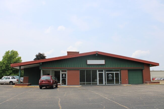
7940 S Sprinkle Rd, Portage, MI 49002


This Property Is For Sale
NEARBY LISTINGS FOR SALE OR LEASE
Property Detail
7940 S Sprinkle Rd
10-00013-080-O
SEC 13-3-11 BEG S1/4 POST SEC 13 TH N ALG NS1/4 LI 233 FT TH W PAR S LI SD SEC 233 FT TH S PAR NS1/4 LI SD SEC 233 FT TO S LI
Commercialnec
Kalamazoo
X
Michigan
26077C0310E
0.84 AC
2025
Southern Kalamazoo County
2025
West Michigan
001905
Kalamazoo-Portage, MI
2,118 SF
DEMOGRAPHICS near 7940 S Sprinkle Rd
1 Mile
3 Mile
5 Mile
2024 Total Population
2,129
19,601
67,456
2029 Population
2,125
19,540
67,189
Pop Growth 2024-2029
(0.19%)
(0.31%)
(0.40%)
Average Age
40
41
39
2024 Total Households
782
8,570
28,471
HH Growth 2024-2029
(0.13%)
(0.37%)
(0.44%)
Median Household Inc
$92,521
$64,959
$66,337
Avg Household Size
2.60
2.20
2.30
2024 Avg HH Vehicles
2.00
2.00
2.00
Median Home Value
$285,837
$202,963
$195,033
Median Year Built
1977
1972
1971
Nearby Places
Map Layers
Map Styles
 Street
 Aerial
- Restaurants
- Banks
- Shops
- Fitness
- Groceries
PUBLIC TRANSPORTATION
COMMUTER RAIL
DRIVE
WALK
Distance
16 min
8.8 mi
AIRPORT
Kalamazoo/Battle Creek International
DRIVE
WALK
Distance
Kalamazoo/Battle Creek International
13 min
4.5 mi
Nearby Properties
Address
Land Use
TOTAL SIZE
Lot Size
Zoning
Address
Land Use
TOTAL SIZE
Lot Size
Zoning
435.98 AC
I-2
Address
Land Use
TOTAL SIZE
Lot Size
Zoning
Address
Land Use
TOTAL SIZE
Lot Size
Zoning
Address
Land Use
TOTAL SIZE
Lot Size
Zoning
82,520 SF
39.35 AC
I-1
Address
Land Use
TOTAL SIZE
Lot Size
Zoning
691,902 SF
12.34 AC
Address
Land Use
TOTAL SIZE
Lot Size
Zoning
35,119 SF
50.85 AC
RM-1
Address
Land Use
TOTAL SIZE
Lot Size
Zoning
78.75 AC
I-2
Address
Land Use
TOTAL SIZE
Lot Size
Zoning
Address
Land Use
TOTAL SIZE
Lot Size
Zoning
Address
Land Use
TOTAL SIZE
Lot Size
Zoning
Address
Land Use
TOTAL SIZE
Lot Size
Zoning
37.40 AC
I-2
Address
Land Use
TOTAL SIZE
Lot Size
Zoning
61.61 AC
Address
Land Use
TOTAL SIZE
Lot Size
Zoning
19.39 AC
OTR
Address
Land Use
TOTAL SIZE
Lot Size
Zoning
37.40 AC
I-2
Address
Land Use
TOTAL SIZE
Lot Size
Zoning
17,858 SF
15.27 AC
RM-1
Address
Land Use
TOTAL SIZE
Lot Size
Zoning
18.57 AC
Address
Land Use
TOTAL SIZE
Lot Size
Zoning
202,798 SF
17.67 AC
I-1
Address
Land Use
TOTAL SIZE
Lot Size
Zoning
Address
Land Use
TOTAL SIZE
Lot Size
Zoning
28.49 AC
I-2
Address
Land Use
TOTAL SIZE
Lot Size
Zoning
291,184 SF
26.35 AC
I-1
Address
Land Use
TOTAL SIZE
Lot Size
Zoning
80,064 SF
6.13 AC
M-1
Address
Land Use
TOTAL SIZE
Lot Size
Zoning
13.77 AC
B-2
Address
Land Use
TOTAL SIZE
Lot Size
Zoning
31.79 AC
I-1
Address
Land Use
TOTAL SIZE
Lot Size
Zoning
129,350 SF
42.30 AC
I-1
Address
Land Use
TOTAL SIZE
Lot Size
Zoning
104,366 SF
9.76 AC
B-3
Address
Land Use
TOTAL SIZE
Lot Size
Zoning
7.36 AC
B-2
Address
Land Use
TOTAL SIZE
Lot Size
Zoning
20,760 SF
12.86 AC
RM-1
Address
Land Use
TOTAL SIZE
Lot Size
Zoning
10.04 AC
I-1
Address
Land Use
TOTAL SIZE
Lot Size
Zoning
103,007 SF
8.02 AC
B-2
Address
Land Use
TOTAL SIZE
Lot Size
Zoning
29,341 SF
5.72 AC
B-2
The World's #1 Commercial Real Estate Marketplace
Connect with us
© 2026 CoStar Group
The information above has been obtained from sources believed reliable. While we do not doubt its accuracy we have not verified it and make no guarantee, warranty or representation about it. It is your responsibility to independently confirm its accuracy and completeness. Any projections, opinions, assumptions, or estimates used are for example only and do not represent the current or future performance of the property. The value of this transaction to you depends on tax and other factors which should be evaluated by your tax, financial, and legal advisors. You and your advisors should conduct a careful, independent investigation of the property to determine to your satisfaction the suitability of the property for your needs.