Property Record
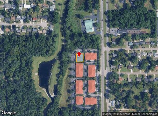
7948 Forest City Rd, Orlando, FL 32810
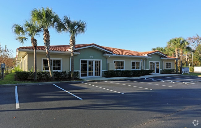
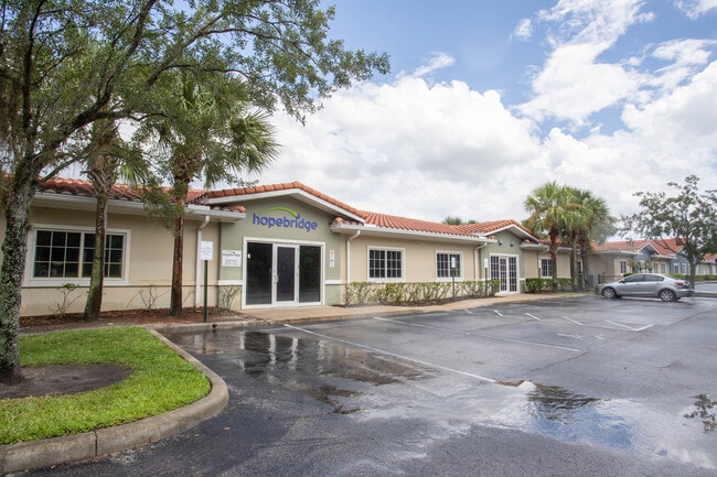

This Property Is For Sale
NEARBY LISTINGS FOR SALE OR LEASE
Property Detail
7948 Forest City Rd
Orlando-Kissimmee-Sanford, FL
Medical Vlg Maitland Condo
28-2129-5515-04-000
MEDICAL VILLAGE MAITLAND CONDOMINIUM 10926/3171 PAD D
Officecondo
Orange
X
Florida
12095C0145F
400
2024
0.22 AC
2025
Maitland Center
015104
Orlando
18,900 SF
DEMOGRAPHICS near 7948 Forest City Rd
1 Mile
3 Mile
5 Mile
2024 Total Population
16,403
97,847
266,047
2029 Population
17,013
100,486
274,247
Pop Growth 2024-2029
+ 3.72%
+ 2.70%
+ 3.08%
Average Age
38
39
40
2024 Total Households
7,069
40,059
107,155
HH Growth 2024-2029
+ 3.93%
+ 2.87%
+ 3.39%
Median Household Inc
$58,856
$56,219
$59,896
Avg Household Size
2.30
2.40
2.40
2024 Avg HH Vehicles
2.00
2.00
2.00
Median Home Value
$203,133
$267,200
$298,027
Median Year Built
1990
1984
1981
Nearby Places
- Restaurants
- Banks
- Shops
- Fitness
- Groceries
PUBLIC TRANSPORTATION
COMMUTER RAIL
DRIVE
WALK
Distance
9 min
4.4 mi
DRIVE
WALK
Distance
12 min
6.0 mi
AIRPORT
Orlando Sanford International
DRIVE
WALK
Distance
Orlando Sanford International
33 min
20.1 mi
Orlando International
DRIVE
WALK
Distance
Orlando International
33 min
20.4 mi
Freight Ports
Port Canaveral
DRIVE
WALK
Distance
Port Canaveral
79 min
62.4 mi
Nearby Properties
Address
Land Use
TOTAL SIZE
Lot Size
Zoning
Address
Land Use
TOTAL SIZE
Lot Size
Zoning
1,009,074 SF
37.77 AC
PD
Address
Land Use
TOTAL SIZE
Lot Size
Zoning
630,861 SF
31.67 AC
PUDMO
Address
Land Use
TOTAL SIZE
Lot Size
Zoning
745,187 SF
18 AC
PUD
Address
Land Use
TOTAL SIZE
Lot Size
Zoning
34,430 SF
19.99 AC
Address
Land Use
TOTAL SIZE
Lot Size
Zoning
507,541 SF
49.48 AC
I-1
Address
Land Use
TOTAL SIZE
Lot Size
Zoning
467,832 SF
20.10 AC
PD
Address
Land Use
TOTAL SIZE
Lot Size
Zoning
1,674 SF
10.53 AC
R3
Address
Land Use
TOTAL SIZE
Lot Size
Zoning
357 SF
17.05 AC
Address
Land Use
TOTAL SIZE
Lot Size
Zoning
384,447 SF
10.70 AC
P-D
Address
Land Use
TOTAL SIZE
Lot Size
Zoning
468,719 SF
45.46 AC
PD
Address
Land Use
TOTAL SIZE
Lot Size
Zoning
381,557 SF
10.09 AC
PD
Address
Land Use
TOTAL SIZE
Lot Size
Zoning
11,392 SF
8.44 AC
Address
Land Use
TOTAL SIZE
Lot Size
Zoning
631,978 SF
7 AC
PD
Address
Land Use
TOTAL SIZE
Lot Size
Zoning
385,111 SF
12.39 AC
PD
Address
Land Use
TOTAL SIZE
Lot Size
Zoning
1,170 SF
17.75 AC
A1
Address
Land Use
TOTAL SIZE
Lot Size
Zoning
269,919 SF
24.44 AC
R-3
Address
Land Use
TOTAL SIZE
Lot Size
Zoning
779,046 SF
14.36 AC
PD
Address
Land Use
TOTAL SIZE
Lot Size
Zoning
447,386 SF
5.73 AC
PD
Address
Land Use
TOTAL SIZE
Lot Size
Zoning
254,477 SF
13.14 AC
MOR2
Address
Land Use
TOTAL SIZE
Lot Size
Zoning
5,924 SF
17.38 AC
R1A
Address
Land Use
TOTAL SIZE
Lot Size
Zoning
539,186 SF
9.14 AC
PD
Address
Land Use
TOTAL SIZE
Lot Size
Zoning
560,422 SF
10 AC
PD
Address
Land Use
TOTAL SIZE
Lot Size
Zoning
243,228 SF
9.21 AC
PD
Address
Land Use
TOTAL SIZE
Lot Size
Zoning
488,884 SF
20.95 AC
WS-RT
Address
Land Use
TOTAL SIZE
Lot Size
Zoning
226,171 SF
9.97 AC
PD
Address
Land Use
TOTAL SIZE
Lot Size
Zoning
254,371 SF
15.63 AC
R1A
Address
Land Use
TOTAL SIZE
Lot Size
Zoning
220,883 SF
53.87 AC
IND-4
Address
Land Use
TOTAL SIZE
Lot Size
Zoning
259,990 SF
14.92 AC
R-3B/W/RP
Address
Land Use
TOTAL SIZE
Lot Size
Zoning
313,692 SF
16.37 AC
R-3A/W/RP
Address
Land Use
TOTAL SIZE
Lot Size
Zoning
296,539 SF
9.57 AC
WS-RT
The World's #1 Commercial Real Estate Marketplace
Connect with us
© 2025 CoStar Group
The information above has been obtained from sources believed reliable. While we do not doubt its accuracy we have not verified it and make no guarantee, warranty or representation about it. It is your responsibility to independently confirm its accuracy and completeness. Any projections, opinions, assumptions, or estimates used are for example only and do not represent the current or future performance of the property. The value of this transaction to you depends on tax and other factors which should be evaluated by your tax, financial, and legal advisors. You and your advisors should conduct a careful, independent investigation of the property to determine to your satisfaction the suitability of the property for your needs.