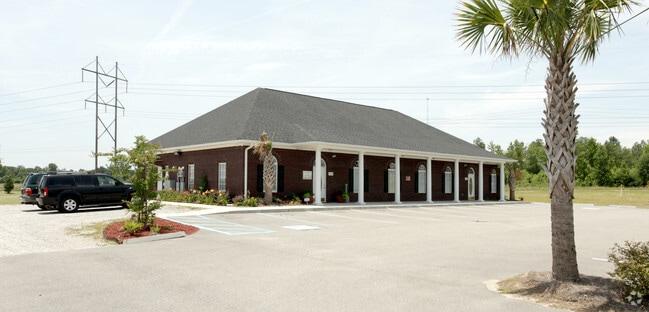
Property Record
795 Cook Rd, Orangeburg, SC 29118

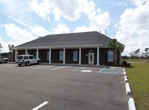
NEARBY LISTINGS FOR SALE OR LEASE
Property Detail
795 Cook Rd
Commercialnec
COOK RD 50 06120003 BLOCK B
X
Orangeburg
45075C0189C
South Carolina
2024
1.45 AC
2024
Other Market Areas
011100
Orangeburg, SC
3,818 SF
0181-11-08-014.000
DEMOGRAPHICS near 795 Cook Rd
1 Mile
3 Mile
5 Mile
2024 Total Population
893
15,953
30,689
2029 Population
873
15,838
30,173
Pop Growth 2024-2029
(2.24%)
(0.72%)
(1.68%)
Average Age
42
37
39
2024 Total Households
383
5,553
11,678
HH Growth 2024-2029
(2.35%)
(0.68%)
(1.76%)
Median Household Inc
$37,159
$27,924
$29,411
Avg Household Size
2.30
2.20
2.30
2024 Avg HH Vehicles
2.00
2.00
2.00
Median Home Value
$169,317
$90,981
$110,699
Median Year Built
1981
1979
1976
Nearby Places
Map Layers
Map Styles
 Street
 Aerial
- Restaurants
- Banks
- Shops
- Fitness
- Groceries
PUBLIC TRANSPORTATION
AIRPORT
Columbia Metro
DRIVE
WALK
Distance
Columbia Metro
53 min
39.1 mi
Freight Ports
North Charleston Terminal
DRIVE
WALK
Distance
North Charleston Terminal
82 min
67.9 mi
Nearby Properties
Address
Land Use
TOTAL SIZE
Lot Size
Zoning
Address
Land Use
TOTAL SIZE
Lot Size
Zoning
331,360 SF
58 AC
Address
Land Use
TOTAL SIZE
Lot Size
Zoning
7,634 SF
0.72 AC
Address
Land Use
TOTAL SIZE
Lot Size
Zoning
206,224 SF
42.20 AC
Address
Land Use
TOTAL SIZE
Lot Size
Zoning
320,700 SF
35.10 AC
Address
Land Use
TOTAL SIZE
Lot Size
Zoning
10,366 SF
98 AC
Address
Land Use
TOTAL SIZE
Lot Size
Zoning
55,136 SF
2.48 AC
Address
Land Use
TOTAL SIZE
Lot Size
Zoning
20,160 SF
3.35 AC
Address
Land Use
TOTAL SIZE
Lot Size
Zoning
56,112 SF
1.90 AC
Address
Land Use
TOTAL SIZE
Lot Size
Zoning
45,873 SF
1.40 AC
Address
Land Use
TOTAL SIZE
Lot Size
Zoning
5,059 SF
3.60 AC
Address
Land Use
TOTAL SIZE
Lot Size
Zoning
43,396 SF
1.98 AC
Address
Land Use
TOTAL SIZE
Lot Size
Zoning
29,977 SF
9.57 AC
Address
Land Use
TOTAL SIZE
Lot Size
Zoning
179,500 SF
83 AC
Address
Land Use
TOTAL SIZE
Lot Size
Zoning
160,648 SF
22.30 AC
Address
Land Use
TOTAL SIZE
Lot Size
Zoning
3,898 SF
2.04 AC
Address
Land Use
TOTAL SIZE
Lot Size
Zoning
30,450 SF
1.98 AC
Address
Land Use
TOTAL SIZE
Lot Size
Zoning
2,500 SF
14.76 AC
Address
Land Use
TOTAL SIZE
Lot Size
Zoning
45,158 SF
2.50 AC
Address
Land Use
TOTAL SIZE
Lot Size
Zoning
29,275 SF
8.50 AC
Address
Land Use
TOTAL SIZE
Lot Size
Zoning
24,824 SF
8.70 AC
Address
Land Use
TOTAL SIZE
Lot Size
Zoning
49,599 SF
3 AC
Address
Land Use
TOTAL SIZE
Lot Size
Zoning
48,997 SF
2 AC
Address
Land Use
TOTAL SIZE
Lot Size
Zoning
226.99 AC
Address
Land Use
TOTAL SIZE
Lot Size
Zoning
28,414 SF
10.20 AC
Address
Land Use
TOTAL SIZE
Lot Size
Zoning
27,466 SF
1.20 AC
Address
Land Use
TOTAL SIZE
Lot Size
Zoning
13,868 SF
7.70 AC
Address
Land Use
TOTAL SIZE
Lot Size
Zoning
16,182 SF
4.02 AC
Address
Land Use
TOTAL SIZE
Lot Size
Zoning
53,348 SF
12.40 AC
Address
Land Use
TOTAL SIZE
Lot Size
Zoning
66,220 SF
25 AC
The World's #1 Commercial Real Estate Marketplace
Connect with us
© 2026 CoStar Group
The information above has been obtained from sources believed reliable. While we do not doubt its accuracy we have not verified it and make no guarantee, warranty or representation about it. It is your responsibility to independently confirm its accuracy and completeness. Any projections, opinions, assumptions, or estimates used are for example only and do not represent the current or future performance of the property. The value of this transaction to you depends on tax and other factors which should be evaluated by your tax, financial, and legal advisors. You and your advisors should conduct a careful, independent investigation of the property to determine to your satisfaction the suitability of the property for your needs.