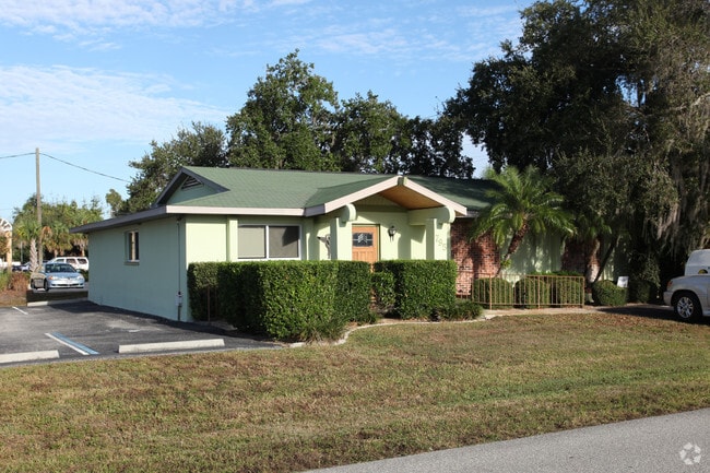
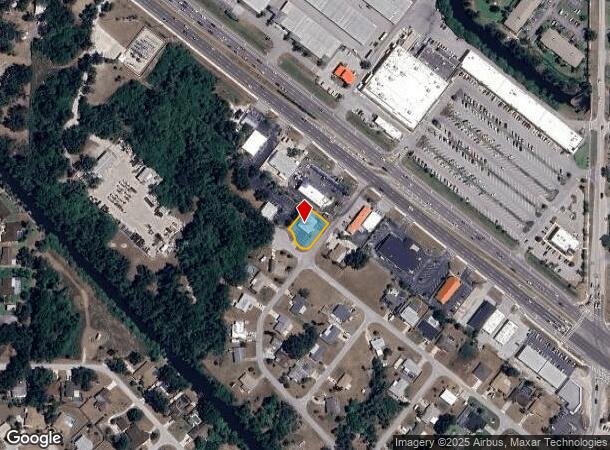
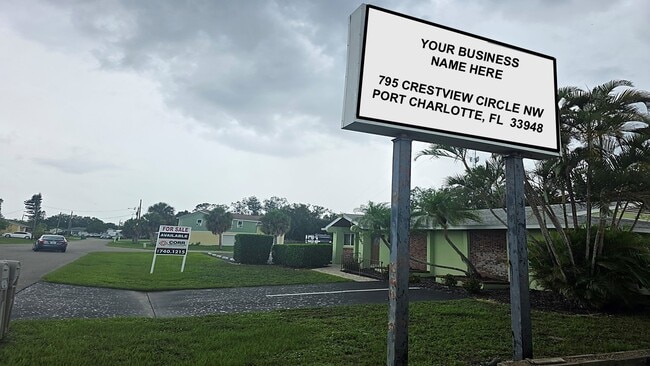
Property Record
795 Crestview Cir Nw, Port Charlotte, FL 33948
Current Lease Availabilities
NEARBY LISTINGS FOR SALE OR LEASE
Property Detail
795 Crestview Cir Nw
Punta Gorda, FL
Port Charlotte
402217227005
PORT CHARLOTTE SEC23 BLK443 LT11 377/314 379/936 465/441 798/392 968/1229 1335/1600 3843/2160 5011/1303
Commercialnec
Charlotte
AE
Florida
12015C0044G
11
2024
0.25 AC
2025
Charlotte County
020303
Southwest Florida
2,314 SF
DEMOGRAPHICS near 795 Crestview Cir Nw
1 Mile
3 Mile
5 Mile
2024 Total Population
7,166
47,896
94,067
2029 Population
8,480
56,801
111,339
Pop Growth 2024-2029
+ 18.34%
+ 18.59%
+ 18.36%
Average Age
52
48
48
2024 Total Households
3,382
20,426
39,779
HH Growth 2024-2029
+ 18.81%
+ 18.90%
+ 18.74%
Median Household Inc
$54,024
$53,110
$57,610
Avg Household Size
2.10
2.20
2.30
2024 Avg HH Vehicles
2.00
2.00
2.00
Median Home Value
$201,099
$216,189
$230,500
Median Year Built
1984
1982
1987
Nearby Places
- Restaurants
- Banks
- Shops
- Fitness
- Groceries
PUBLIC TRANSPORTATION
AIRPORT
Punta Gorda
DRIVE
WALK
Distance
Punta Gorda
21 min
10.9 mi
Freight Ports
Port Manatee
DRIVE
WALK
Distance
Port Manatee
80 min
64.1 mi
Nearby Properties
Address
Land Use
TOTAL SIZE
Lot Size
Zoning
Address
Land Use
TOTAL SIZE
Lot Size
Zoning
156,350 SF
12.49 AC
OMI
Address
Land Use
TOTAL SIZE
Lot Size
Zoning
129,475 SF
16.04 AC
OMI
Address
Land Use
TOTAL SIZE
Lot Size
Zoning
198,132 SF
17.61 AC
RMF15
Address
Land Use
TOTAL SIZE
Lot Size
Zoning
53,564 SF
22 AC
PD
Address
Land Use
TOTAL SIZE
Lot Size
Zoning
261,557 SF
46.25 AC
OMI
Address
Land Use
TOTAL SIZE
Lot Size
Zoning
196,676 SF
30 AC
OMI
Address
Land Use
TOTAL SIZE
Lot Size
Zoning
174,965 SF
13.52 AC
CG
Address
Land Use
TOTAL SIZE
Lot Size
Zoning
238,852 SF
26.63 AC
CG
Address
Land Use
TOTAL SIZE
Lot Size
Zoning
583,831 SF
54.32 AC
CG
Address
Land Use
TOTAL SIZE
Lot Size
Zoning
119,749 SF
12.90 AC
RSF3.5
Address
Land Use
TOTAL SIZE
Lot Size
Zoning
141,619 SF
12.39 AC
II
Address
Land Use
TOTAL SIZE
Lot Size
Zoning
208,372 SF
21.98 AC
II
Address
Land Use
TOTAL SIZE
Lot Size
Zoning
122,030 SF
7.43 AC
CG
Address
Land Use
TOTAL SIZE
Lot Size
Zoning
141,647 SF
20.29 AC
CG
Address
Land Use
TOTAL SIZE
Lot Size
Zoning
102,337 SF
10.43 AC
RSF3.5
Address
Land Use
TOTAL SIZE
Lot Size
Zoning
98,599 SF
9.75 AC
CG
Address
Land Use
TOTAL SIZE
Lot Size
Zoning
107,237 SF
20.14 AC
CG
Address
Land Use
TOTAL SIZE
Lot Size
Zoning
91,281 SF
10 AC
CG
Address
Land Use
TOTAL SIZE
Lot Size
Zoning
95.20 AC
PD
Address
Land Use
TOTAL SIZE
Lot Size
Zoning
96,253 SF
7.89 AC
CG
Address
Land Use
TOTAL SIZE
Lot Size
Zoning
37,045 SF
21.20 AC
PD
Address
Land Use
TOTAL SIZE
Lot Size
Zoning
88,259 SF
4.71 AC
CG
Address
Land Use
TOTAL SIZE
Lot Size
Zoning
12,101 SF
15.92 AC
ES
Address
Land Use
TOTAL SIZE
Lot Size
Zoning
4,562 SF
8.08 AC
CG
Address
Land Use
TOTAL SIZE
Lot Size
Zoning
135,717 SF
10.55 AC
CG
Address
Land Use
TOTAL SIZE
Lot Size
Zoning
34,975 SF
2.90 AC
RMF15
Address
Land Use
TOTAL SIZE
Lot Size
Zoning
82,800 SF
9.45 AC
CG
Address
Land Use
TOTAL SIZE
Lot Size
Zoning
35,587 SF
6.27 AC
RMF15
Address
Land Use
TOTAL SIZE
Lot Size
Zoning
74,447 SF
4.50 AC
CG
Address
Land Use
TOTAL SIZE
Lot Size
Zoning
22,919 SF
4.70 AC
CG
The World's #1 Commercial Real Estate Marketplace
Connect with us
© 2025 CoStar Group
The information above has been obtained from sources believed reliable. While we do not doubt its accuracy we have not verified it and make no guarantee, warranty or representation about it. It is your responsibility to independently confirm its accuracy and completeness. Any projections, opinions, assumptions, or estimates used are for example only and do not represent the current or future performance of the property. The value of this transaction to you depends on tax and other factors which should be evaluated by your tax, financial, and legal advisors. You and your advisors should conduct a careful, independent investigation of the property to determine to your satisfaction the suitability of the property for your needs.