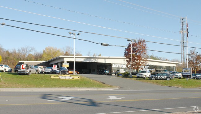
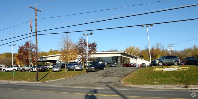
Property Record
795 Hoosick Rd, Troy, NY 12180


NEARBY LISTINGS FOR SALE OR LEASE
Property Detail
795 Hoosick Rd
382200 91.-2-27.111
Rensselaer
Vehiclerentalsvehiclesales
New York
ARE
27.111
36083C0232D
3.81 AC
2025
Outer Rensselaer County
2024
Albany/Schenectady/Troy
052003
Albany-Schenectady-Troy, NY
35,550 SF
DEMOGRAPHICS near 795 Hoosick Rd
1 Mile
3 Mile
5 Mile
2024 Total Population
2,843
44,341
111,748
2029 Population
2,881
43,905
110,018
Pop Growth 2024-2029
+ 1.34%
(0.98%)
(1.55%)
Average Age
44
39
39
2024 Total Households
1,329
18,505
48,508
HH Growth 2024-2029
+ 1.35%
(1.01%)
(1.65%)
Median Household Inc
$96,641
$54,875
$59,423
Avg Household Size
2.10
2.10
2.10
2024 Avg HH Vehicles
2.00
1.00
1.00
Median Home Value
$255,992
$197,163
$191,817
Median Year Built
1986
1950
1953
Nearby Places
Map Layers
Map Styles
 Street
 Aerial
- Restaurants
- Banks
- Shops
- Fitness
- Groceries
PUBLIC TRANSPORTATION
AIRPORT
Albany International
DRIVE
WALK
Distance
Albany International
17 min
9.9 mi
Freight Ports
Albany, NY Port
DRIVE
WALK
Distance
Albany, NY Port
22 min
12.7 mi
Nearby Properties
Address
Land Use
TOTAL SIZE
Lot Size
Zoning
Address
Land Use
TOTAL SIZE
Lot Size
Zoning
34,971 SF
108.68 AC
CI
Address
Land Use
TOTAL SIZE
Lot Size
Zoning
313,907 SF
8.23 AC
CI
Address
Land Use
TOTAL SIZE
Lot Size
Zoning
9,643 SF
5.36 AC
CI
Address
Land Use
TOTAL SIZE
Lot Size
Zoning
Address
Land Use
TOTAL SIZE
Lot Size
Zoning
5,000 SF
48.44 AC
CR
Address
Land Use
TOTAL SIZE
Lot Size
Zoning
35,392 SF
73.57 AC
CI
Address
Land Use
TOTAL SIZE
Lot Size
Zoning
413,006 SF
37.94 AC
CI
Address
Land Use
TOTAL SIZE
Lot Size
Zoning
67,335 SF
65.54 AC
CI
Address
Land Use
TOTAL SIZE
Lot Size
Zoning
38,176 SF
8.99 AC
06 - INDUS
Address
Land Use
TOTAL SIZE
Lot Size
Zoning
77,193 SF
28.41 AC
SF
Address
Land Use
TOTAL SIZE
Lot Size
Zoning
353,510 SF
2.94 AC
WMU
Address
Land Use
TOTAL SIZE
Lot Size
Zoning
Address
Land Use
TOTAL SIZE
Lot Size
Zoning
10,271 SF
11.22 AC
05 - COMME
Address
Land Use
TOTAL SIZE
Lot Size
Zoning
16,698 SF
46.45 AC
MF
Address
Land Use
TOTAL SIZE
Lot Size
Zoning
251,672 SF
16.18 AC
06 - INDUS
Address
Land Use
TOTAL SIZE
Lot Size
Zoning
113,400 SF
3.40 AC
CI
Address
Land Use
TOTAL SIZE
Lot Size
Zoning
210,415 SF
1.69 AC
MF
Address
Land Use
TOTAL SIZE
Lot Size
Zoning
77,928 SF
2.25 AC
WMU
Address
Land Use
TOTAL SIZE
Lot Size
Zoning
5,500 SF
15.31 AC
MU2
Address
Land Use
TOTAL SIZE
Lot Size
Zoning
148,200 SF
7.43 AC
06 - INDUS
Address
Land Use
TOTAL SIZE
Lot Size
Zoning
1,500 SF
7.01 AC
WMU
Address
Land Use
TOTAL SIZE
Lot Size
Zoning
154,587 SF
3.79 AC
CC
Address
Land Use
TOTAL SIZE
Lot Size
Zoning
155,900 SF
1.30 AC
DMU
Address
Land Use
TOTAL SIZE
Lot Size
Zoning
3,600 SF
17.54 AC
MF
Address
Land Use
TOTAL SIZE
Lot Size
Zoning
116,015 SF
2.32 AC
DMU
Address
Land Use
TOTAL SIZE
Lot Size
Zoning
63,828 SF
2.74 AC
CI
Address
Land Use
TOTAL SIZE
Lot Size
Zoning
102,000 SF
0.86 AC
DMU
Address
Land Use
TOTAL SIZE
Lot Size
Zoning
97,884 SF
0.75 AC
DMU
Address
Land Use
TOTAL SIZE
Lot Size
Zoning
3,202 SF
7.34 AC
CI
Address
Land Use
TOTAL SIZE
Lot Size
Zoning
The World's #1 Commercial Real Estate Marketplace
Connect with us
© 2025 CoStar Group
The information above has been obtained from sources believed reliable. While we do not doubt its accuracy we have not verified it and make no guarantee, warranty or representation about it. It is your responsibility to independently confirm its accuracy and completeness. Any projections, opinions, assumptions, or estimates used are for example only and do not represent the current or future performance of the property. The value of this transaction to you depends on tax and other factors which should be evaluated by your tax, financial, and legal advisors. You and your advisors should conduct a careful, independent investigation of the property to determine to your satisfaction the suitability of the property for your needs.