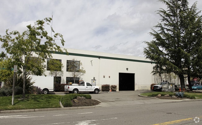
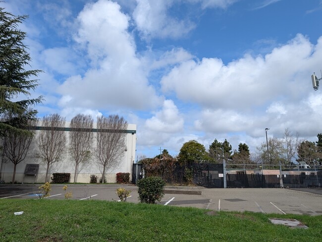
Property Record
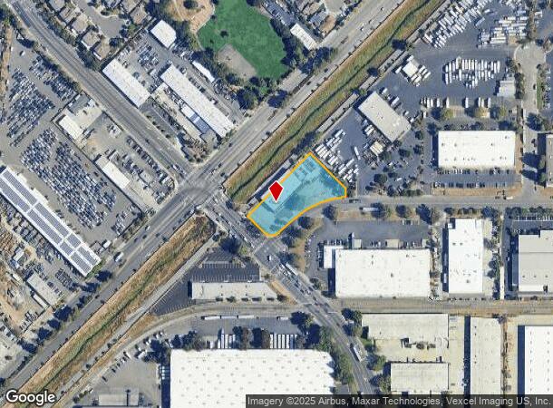
795 Sandoval Way, Hayward, CA 94544

Current Lease Availabilities
NEARBY LISTINGS FOR SALE OR LEASE
Property Detail
795 Sandoval Way
475-0021-042-03
Parcel Map 2851
Warehouse
LOT: 0000C BLK: PM: 0111 PAGE: 0001
AH
Alameda
06001C0431G
California
2024
1 AC
2025
Hayward/Castro Valley
438203
East Bay/Oakland
11,005 SF
Oakland-Hayward-Berkeley, CA
DEMOGRAPHICS near 795 Sandoval Way
1 Mile
3 Mile
5 Mile
2024 Total Population
20,307
156,549
324,362
2029 Population
19,941
151,612
313,618
Pop Growth 2024-2029
(1.80%)
(3.15%)
(3.31%)
Average Age
41
40
40
2024 Total Households
6,399
46,069
101,054
HH Growth 2024-2029
(1.97%)
(3.33%)
(3.51%)
Median Household Inc
$95,665
$107,303
$116,127
Avg Household Size
3.00
3.20
3.10
2024 Avg HH Vehicles
2.00
2.00
2.00
Median Home Value
$632,017
$794,961
$864,482
Median Year Built
1979
1974
1975
Nearby Places
Map Layers
Map Styles
 Street
 Aerial
- Restaurants
- Banks
- Shops
- Fitness
- Groceries
PUBLIC TRANSPORTATION
COMMUTER RAIL
DRIVE
WALK
Distance
10 min
5.8 mi
DRIVE
WALK
Distance
10 min
5.8 mi
AIRPORT
Metro Oakland International
DRIVE
WALK
Distance
Metro Oakland International
20 min
13.9 mi
San Francisco International
DRIVE
WALK
Distance
San Francisco International
32 min
24.5 mi
Norman Y Mineta San Jose International
DRIVE
WALK
Distance
Norman Y Mineta San Jose International
32 min
24.6 mi
Freight Ports
Port of Oakland
DRIVE
WALK
Distance
Port of Oakland
25 min
18.5 mi
Nearby Properties
Address
Land Use
TOTAL SIZE
Lot Size
Zoning
Address
Land Use
TOTAL SIZE
Lot Size
Zoning
176,707 SF
2.47 AC
Address
Land Use
TOTAL SIZE
Lot Size
Zoning
312,244 SF
31.84 AC
Address
Land Use
TOTAL SIZE
Lot Size
Zoning
52,720 SF
4.21 AC
Address
Land Use
TOTAL SIZE
Lot Size
Zoning
236,976 SF
18.36 AC
Address
Land Use
TOTAL SIZE
Lot Size
Zoning
173,948 SF
6.10 AC
Address
Land Use
TOTAL SIZE
Lot Size
Zoning
333,302 SF
13.20 AC
Address
Land Use
TOTAL SIZE
Lot Size
Zoning
175,325 SF
2.91 AC
Address
Land Use
TOTAL SIZE
Lot Size
Zoning
470,929 SF
31.62 AC
Address
Land Use
TOTAL SIZE
Lot Size
Zoning
258,470 SF
11.64 AC
Address
Land Use
TOTAL SIZE
Lot Size
Zoning
58,991 SF
9.56 AC
Address
Land Use
TOTAL SIZE
Lot Size
Zoning
150,856 SF
5.99 AC
Address
Land Use
TOTAL SIZE
Lot Size
Zoning
234,858 SF
8.72 AC
I
Address
Land Use
TOTAL SIZE
Lot Size
Zoning
89,145 SF
5.12 AC
Address
Land Use
TOTAL SIZE
Lot Size
Zoning
146,599 SF
13.72 AC
Address
Land Use
TOTAL SIZE
Lot Size
Zoning
116,485 SF
1.81 AC
Address
Land Use
TOTAL SIZE
Lot Size
Zoning
Address
Land Use
TOTAL SIZE
Lot Size
Zoning
154,113 SF
14.10 AC
Address
Land Use
TOTAL SIZE
Lot Size
Zoning
124,292 SF
9.69 AC
Address
Land Use
TOTAL SIZE
Lot Size
Zoning
89,344 SF
4.36 AC
Address
Land Use
TOTAL SIZE
Lot Size
Zoning
214,200 SF
9.04 AC
Address
Land Use
TOTAL SIZE
Lot Size
Zoning
200,384 SF
10.26 AC
Address
Land Use
TOTAL SIZE
Lot Size
Zoning
266,149 SF
13.45 AC
I
Address
Land Use
TOTAL SIZE
Lot Size
Zoning
92,922 SF
5 AC
Address
Land Use
TOTAL SIZE
Lot Size
Zoning
100,128 SF
0.98 AC
Address
Land Use
TOTAL SIZE
Lot Size
Zoning
79,075 SF
4.32 AC
Address
Land Use
TOTAL SIZE
Lot Size
Zoning
128,700 SF
11.21 AC
Address
Land Use
TOTAL SIZE
Lot Size
Zoning
64,127 SF
5.34 AC
Address
Land Use
TOTAL SIZE
Lot Size
Zoning
131,486 SF
55.82 AC
Address
Land Use
TOTAL SIZE
Lot Size
Zoning
232,864 SF
12.23 AC
Address
Land Use
TOTAL SIZE
Lot Size
Zoning
94,046 SF
4.68 AC
The World's #1 Commercial Real Estate Marketplace
Connect with us
© 2026 CoStar Group
The information above has been obtained from sources believed reliable. While we do not doubt its accuracy we have not verified it and make no guarantee, warranty or representation about it. It is your responsibility to independently confirm its accuracy and completeness. Any projections, opinions, assumptions, or estimates used are for example only and do not represent the current or future performance of the property. The value of this transaction to you depends on tax and other factors which should be evaluated by your tax, financial, and legal advisors. You and your advisors should conduct a careful, independent investigation of the property to determine to your satisfaction the suitability of the property for your needs.