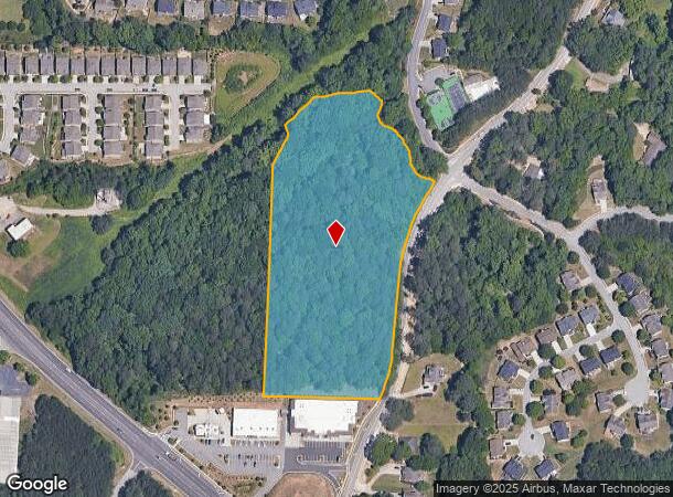
Property Record
Buckner Rd, Mableton, GA 30126
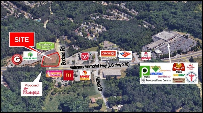
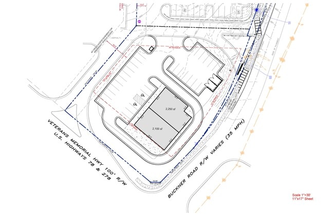
This Property Is For Sale
Current Lease Availabilities
NEARBY LISTINGS FOR SALE OR LEASE
Property Detail
Buckner Rd
18-0068-0-009-0
Homesite
Recreationalacreage
Cobb
A
Georgia
13067C0217J
7.50 AC
2025
Cumberland/Galleria
2025
Atlanta
031315
Atlanta-Sandy Springs-Roswell, GA
DEMOGRAPHICS near Buckner Rd
1 Mile
3 Mile
5 Mile
2024 Total Population
6,938
54,450
177,702
2029 Population
7,072
55,674
182,753
Pop Growth 2024-2029
+ 1.93%
+ 2.25%
+ 2.84%
Average Age
37
37
38
2024 Total Households
2,703
21,654
71,653
HH Growth 2024-2029
+ 1.92%
+ 2.18%
+ 2.89%
Median Household Inc
$124,651
$84,308
$76,280
Avg Household Size
2.50
2.50
2.40
2024 Avg HH Vehicles
2.00
2.00
2.00
Median Home Value
$350,500
$331,303
$333,564
Median Year Built
2004
1993
1987
Nearby Places
- Restaurants
- Banks
- Shops
- Fitness
- Groceries
PUBLIC TRANSPORTATION
AIRPORT
Hartsfield - Jackson Atlanta International
DRIVE
WALK
Distance
Hartsfield - Jackson Atlanta International
30 min
19.3 mi
Freight Ports
Georgia Ports - Savannah
DRIVE
WALK
Distance
Georgia Ports - Savannah
292 min
258.7 mi
Nearby Properties
Address
Land Use
TOTAL SIZE
Lot Size
Zoning
Address
Land Use
TOTAL SIZE
Lot Size
Zoning
Address
Land Use
TOTAL SIZE
Lot Size
Zoning
3.25 AC
MU
Address
Land Use
TOTAL SIZE
Lot Size
Zoning
1,151,446 SF
I2
Address
Land Use
TOTAL SIZE
Lot Size
Zoning
439,167 SF
41.13 AC
RM-12
Address
Land Use
TOTAL SIZE
Lot Size
Zoning
403,687 SF
42.37 AC
RM-12
Address
Land Use
TOTAL SIZE
Lot Size
Zoning
538,535 SF
32.40 AC
I2
Address
Land Use
TOTAL SIZE
Lot Size
Zoning
415,834 SF
17.62 AC
I2
Address
Land Use
TOTAL SIZE
Lot Size
Zoning
263,676 SF
15.70 AC
RM-12
Address
Land Use
TOTAL SIZE
Lot Size
Zoning
285.03 AC
I2
Address
Land Use
TOTAL SIZE
Lot Size
Zoning
694,436 SF
36.80 AC
HI
Address
Land Use
TOTAL SIZE
Lot Size
Zoning
283,396 SF
29.88 AC
RM-12
Address
Land Use
TOTAL SIZE
Lot Size
Zoning
251,706 SF
20.22 AC
RM-12
Address
Land Use
TOTAL SIZE
Lot Size
Zoning
237,515 SF
16.68 AC
C2
Address
Land Use
TOTAL SIZE
Lot Size
Zoning
211,506 SF
20.63 AC
CRC
Address
Land Use
TOTAL SIZE
Lot Size
Zoning
520,556 SF
5.47 AC
RG2
Address
Land Use
TOTAL SIZE
Lot Size
Zoning
191,400 SF
25.70 AC
LI
Address
Land Use
TOTAL SIZE
Lot Size
Zoning
152,348 SF
12.76 AC
RM-12
Address
Land Use
TOTAL SIZE
Lot Size
Zoning
150,440 SF
25 AC
LI
Address
Land Use
TOTAL SIZE
Lot Size
Zoning
175,630 SF
5.06 AC
RM-12
Address
Land Use
TOTAL SIZE
Lot Size
Zoning
420,810 SF
23.48 AC
I1
Address
Land Use
TOTAL SIZE
Lot Size
Zoning
377,059 SF
32.20 AC
LI
Address
Land Use
TOTAL SIZE
Lot Size
Zoning
286,400 SF
17.29 AC
I2
Address
Land Use
TOTAL SIZE
Lot Size
Zoning
332,329 SF
4.99 AC
R5
Address
Land Use
TOTAL SIZE
Lot Size
Zoning
94,230 SF
12.47 AC
GC
Address
Land Use
TOTAL SIZE
Lot Size
Zoning
3,000 SF
11.42 AC
HI
Address
Land Use
TOTAL SIZE
Lot Size
Zoning
217,412 SF
18.29 AC
RM-12
Address
Land Use
TOTAL SIZE
Lot Size
Zoning
111,246 SF
11.28 AC
RM-12
Address
Land Use
TOTAL SIZE
Lot Size
Zoning
229,860 SF
4.27 AC
RG2
Address
Land Use
TOTAL SIZE
Lot Size
Zoning
903,588 SF
6.94 AC
RG3
Address
Land Use
TOTAL SIZE
Lot Size
Zoning
55,788 SF
44.07 AC
I1
The World's #1 Commercial Real Estate Marketplace
Connect with us
© 2025 CoStar Group
The information above has been obtained from sources believed reliable. While we do not doubt its accuracy we have not verified it and make no guarantee, warranty or representation about it. It is your responsibility to independently confirm its accuracy and completeness. Any projections, opinions, assumptions, or estimates used are for example only and do not represent the current or future performance of the property. The value of this transaction to you depends on tax and other factors which should be evaluated by your tax, financial, and legal advisors. You and your advisors should conduct a careful, independent investigation of the property to determine to your satisfaction the suitability of the property for your needs.