Property Record
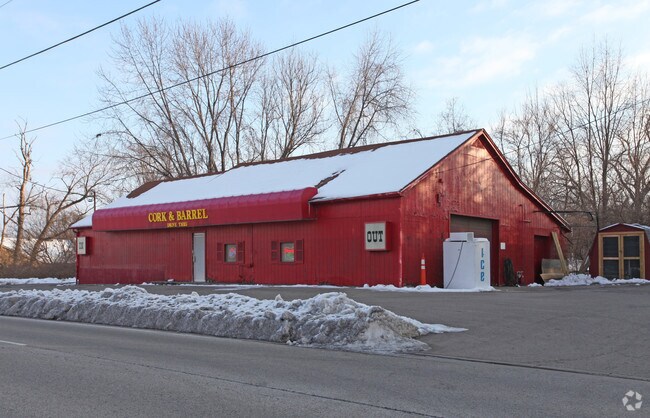
7950 Cincinnati Dayton Rd, West Chester, OH 45069


NEARBY LISTINGS FOR SALE OR LEASE
-
-
-
-
-
-
-
No Photo
-
View all West Chester listings for sale on LoopNet.com
Property Detail
7950 Cincinnati Dayton Rd
Cincinnati, OH-KY-IN
Village/Maud
M5640-024-000-029
116 S 233.5 OF N278.5 OF W105.3 SEE TIF PCL 029T - CINTI DAYTON RD TIF
Storebuilding
Butler
X
Ohio
39017C0332F
116
2024
0.40 AC
2025
Butler County
011126
Cincinnati/Dayton
3,108 SF
DEMOGRAPHICS near 7950 Cincinnati Dayton Rd
1 Mile
3 Mile
5 Mile
2024 Total Population
9,482
55,136
143,098
2029 Population
9,667
55,962
147,634
Pop Growth 2024-2029
+ 1.95%
+ 1.50%
+ 3.17%
Average Age
38
40
39
2024 Total Households
3,632
19,985
50,956
HH Growth 2024-2029
+ 1.84%
+ 1.41%
+ 3.07%
Median Household Inc
$89,692
$114,194
$115,455
Avg Household Size
2.50
2.70
2.70
2024 Avg HH Vehicles
2.00
2.00
2.00
Median Home Value
$282,930
$276,412
$301,152
Median Year Built
1985
1989
1993
Nearby Places
Map Layers
Map Styles
 Street
 Aerial
- Restaurants
- Banks
- Shops
- Fitness
- Groceries
PUBLIC TRANSPORTATION
AIRPORT
Cincinnati/Northern Kentucky International
DRIVE
WALK
Distance
Cincinnati/Northern Kentucky International
49 min
33.0 mi
Nearby Properties
Address
Land Use
TOTAL SIZE
Lot Size
Zoning
Address
Land Use
TOTAL SIZE
Lot Size
Zoning
21,549 SF
30.60 AC
Address
Land Use
TOTAL SIZE
Lot Size
Zoning
10.76 AC
Address
Land Use
TOTAL SIZE
Lot Size
Zoning
11.19 AC
Address
Land Use
TOTAL SIZE
Lot Size
Zoning
1,764 SF
17.27 AC
Address
Land Use
TOTAL SIZE
Lot Size
Zoning
431,936 SF
14.27 AC
Address
Land Use
TOTAL SIZE
Lot Size
Zoning
987,717 SF
57.32 AC
Address
Land Use
TOTAL SIZE
Lot Size
Zoning
136,681 SF
22.56 AC
Address
Land Use
TOTAL SIZE
Lot Size
Zoning
54,055 SF
18.17 AC
Address
Land Use
TOTAL SIZE
Lot Size
Zoning
300,943 SF
23.01 AC
Address
Land Use
TOTAL SIZE
Lot Size
Zoning
84,133 SF
4.28 AC
Address
Land Use
TOTAL SIZE
Lot Size
Zoning
179,048 SF
12.32 AC
Address
Land Use
TOTAL SIZE
Lot Size
Zoning
105,280 SF
11.19 AC
Address
Land Use
TOTAL SIZE
Lot Size
Zoning
105,280 SF
10.76 AC
Address
Land Use
TOTAL SIZE
Lot Size
Zoning
62.02 AC
Address
Land Use
TOTAL SIZE
Lot Size
Zoning
Address
Land Use
TOTAL SIZE
Lot Size
Zoning
188,177 SF
4.62 AC
Address
Land Use
TOTAL SIZE
Lot Size
Zoning
433,277 SF
25.66 AC
Address
Land Use
TOTAL SIZE
Lot Size
Zoning
262,173 SF
2.32 AC
Address
Land Use
TOTAL SIZE
Lot Size
Zoning
158,680 SF
22.49 AC
Address
Land Use
TOTAL SIZE
Lot Size
Zoning
45,298 SF
20.43 AC
Address
Land Use
TOTAL SIZE
Lot Size
Zoning
105,144 SF
6.86 AC
Address
Land Use
TOTAL SIZE
Lot Size
Zoning
269,222 SF
24.52 AC
Address
Land Use
TOTAL SIZE
Lot Size
Zoning
99,228 SF
15.86 AC
Address
Land Use
TOTAL SIZE
Lot Size
Zoning
178,374 SF
2.14 AC
Address
Land Use
TOTAL SIZE
Lot Size
Zoning
107,304 SF
0.70 AC
Address
Land Use
TOTAL SIZE
Lot Size
Zoning
158,018 SF
38.69 AC
Address
Land Use
TOTAL SIZE
Lot Size
Zoning
68,460 SF
7.58 AC
Address
Land Use
TOTAL SIZE
Lot Size
Zoning
Address
Land Use
TOTAL SIZE
Lot Size
Zoning
Address
Land Use
TOTAL SIZE
Lot Size
Zoning
64,652 SF
7.63 AC
The World's #1 Commercial Real Estate Marketplace
Connect with us
© 2026 CoStar Group
The information above has been obtained from sources believed reliable. While we do not doubt its accuracy we have not verified it and make no guarantee, warranty or representation about it. It is your responsibility to independently confirm its accuracy and completeness. Any projections, opinions, assumptions, or estimates used are for example only and do not represent the current or future performance of the property. The value of this transaction to you depends on tax and other factors which should be evaluated by your tax, financial, and legal advisors. You and your advisors should conduct a careful, independent investigation of the property to determine to your satisfaction the suitability of the property for your needs.