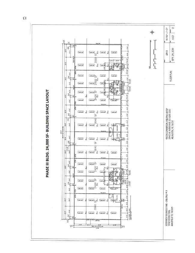
Property Record
7950 Rodeo Trl, Mansfield, TX 76063


Property Detail
7950 Rodeo Trl
Dallas-Fort Worth-Arlington, TX
SOUTHWEST BUSINESS PARK BLOCK 1 LOT 3
41397134
Tarrant
Commercialnec
Texas
AE The base floodplain where base flood elevations are provided. AE Zones are now used on new format FIRMs instead of A1-A30 Zones.
3
2025
4.41 AC
2025
S Cen.Tarrant Cnty
111317
Dallas/Ft Worth
41,078 SF
NEARBY LISTINGS FOR SALE OR LEASE
DEMOGRAPHICS near 7950 Rodeo Trl
1 mile
3 mile
5 mile
2025 Total Population
1,298
26,129
92,067
2030 Population
1,387
28,008
98,391
Pop Growth 2025-2030
+ 6.86%
+ 7.19%
+ 6.87%
Average Age
39
38
39
2025 Total Households
418
9,023
31,320
HH Growth 2025-2030
+ 6.94%
+ 7.43%
+ 7.00%
Median Household Inc
$97,655
$88,059
$104,746
Avg Household Size
3.10
2.80
2.90
2025 Avg HH Vehicles
2.00
2.00
2.00
Median Home Value
$513,975
$413,756
$394,261
Median Year Built
2000
2003
1999
Nearby Places
Map Layers
Map Styles
 Street
 Aerial
Layers
 Traffic
 Biking
Places
Listings with unknown addresses are not visible on the map
- Restaurants
- Banks
- Shops
- Fitness
- Groceries
PUBLIC TRANSPORTATION
AIRPORT
Dallas-Fort Worth International
Drive
Walk
Distance
Dallas-Fort Worth International
44 min
29.5 mi
Dallas Love Field
Drive
Walk
Distance
Dallas Love Field
55 min
38.1 mi
Freight Ports
Port of Shreveport
Drive
Walk
Distance
Port of Shreveport
246 min
223.8 mi
SALE & LEASE HISTORY
LISTING DATE
SALE/LEASE

Dec 29, 2017
For Lease
Aug 29, 2017
For Lease
Nearby Properties
Address
Land Use
TOTAL SIZE
Lot Size
Zoning
Address
Land Use
TOTAL SIZE
Lot Size
Zoning
348,951 SF
18.66 AC
Address
Land Use
TOTAL SIZE
Lot Size
Zoning
317,142 SF
11.40 AC
Address
Land Use
TOTAL SIZE
Lot Size
Zoning
160,000 SF
26.90 AC
Address
Land Use
TOTAL SIZE
Lot Size
Zoning
413,000 SF
19.16 AC
Address
Land Use
TOTAL SIZE
Lot Size
Zoning
298,988 SF
7.16 AC
Address
Land Use
TOTAL SIZE
Lot Size
Zoning
276,467 SF
7.61 AC
Address
Land Use
TOTAL SIZE
Lot Size
Zoning
249,922 SF
17.26 AC
Address
Land Use
TOTAL SIZE
Lot Size
Zoning
170,082 SF
36.49 AC
Address
Land Use
TOTAL SIZE
Lot Size
Zoning
724,286 SF
48.41 AC
Address
Land Use
TOTAL SIZE
Lot Size
Zoning
231,551 SF
25.69 AC
Address
Land Use
TOTAL SIZE
Lot Size
Zoning
234,580 SF
65.82 AC
Address
Land Use
TOTAL SIZE
Lot Size
Zoning
229,168 SF
6.13 AC
Address
Land Use
TOTAL SIZE
Lot Size
Zoning
149,494 SF
3.73 AC
Address
Land Use
TOTAL SIZE
Lot Size
Zoning
79,070 SF
11.98 AC
Address
Land Use
TOTAL SIZE
Lot Size
Zoning
275,337 SF
14 AC
Address
Land Use
TOTAL SIZE
Lot Size
Zoning
85,000 SF
13.03 AC
Address
Land Use
TOTAL SIZE
Lot Size
Zoning
158,103 SF
13.27 AC
Address
Land Use
TOTAL SIZE
Lot Size
Zoning
85,786 SF
9.43 AC
Address
Land Use
TOTAL SIZE
Lot Size
Zoning
22.84 AC
Address
Land Use
TOTAL SIZE
Lot Size
Zoning
41,960 SF
13.70 AC
Address
Land Use
TOTAL SIZE
Lot Size
Zoning
36,962 SF
3.69 AC
Address
Land Use
TOTAL SIZE
Lot Size
Zoning
143,210 SF
9.78 AC
Address
Land Use
TOTAL SIZE
Lot Size
Zoning
76,715 SF
7.98 AC
Address
Land Use
TOTAL SIZE
Lot Size
Zoning
73,323 SF
11.87 AC
Address
Land Use
TOTAL SIZE
Lot Size
Zoning
1,008 SF
20.48 AC
Address
Land Use
TOTAL SIZE
Lot Size
Zoning
123,530 SF
27.29 AC
Address
Land Use
TOTAL SIZE
Lot Size
Zoning
107,723 SF
9.06 AC
Address
Land Use
TOTAL SIZE
Lot Size
Zoning
166,434 SF
9.20 AC
Address
Land Use
TOTAL SIZE
Lot Size
Zoning
174,700 SF
14.15 AC
Address
Land Use
TOTAL SIZE
Lot Size
Zoning
112,110 SF
14.64 AC
The World's #1 Commercial Real Estate Marketplace
Connect with us
© 2026 CoStar Group
The information above has been obtained from sources believed reliable. While we do not doubt its accuracy we have not verified it and make no guarantee, warranty or representation about it. It is your responsibility to independently confirm its accuracy and completeness. Any projections, opinions, assumptions, or estimates used are for example only and do not represent the current or future performance of the property. The value of this transaction to you depends on tax and other factors which should be evaluated by your tax, financial, and legal advisors. You and your advisors should conduct a careful, independent investigation of the property to determine to your satisfaction the suitability of the property for your needs.