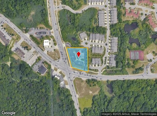
Property Record
7950 W Maple Rd, West Bloomfield, MI 48322
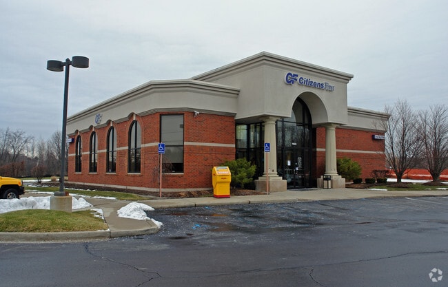

This Property Is For Sale
NEARBY LISTINGS FOR SALE OR LEASE
Property Detail
7950 W Maple Rd
18-30-326-012
T2N, R9E, SEC 30 PART OF SW 1/4 BEG AT PT DIST N 89-41-03 E 384.94 FT & N 00-29-42 E 79.79 FT FROM SW SEC COR, TH ALG CURVE TO RIGHT, RAD 895.37 FT, CHORD BEARS N 72-00-30 W 194.65 FT, DIST OF 195.04 FT, TH N 13-27-22 W 225 FT, TH S 87-47-48 E 240 FT
Commercialnec
Oakland
X
Michigan
26125C0491F
1.19 AC
2024
Bloomfield West
2024
Detroit
157200
Detroit-Warren-Dearborn, MI
4,387 SF
DEMOGRAPHICS near 7950 W Maple Rd
1 Mile
3 Mile
5 Mile
2024 Total Population
5,733
66,659
160,715
2029 Population
5,759
66,116
158,992
Pop Growth 2024-2029
+ 0.45%
(0.81%)
(1.07%)
Average Age
44
45
43
2024 Total Households
2,216
27,769
67,345
HH Growth 2024-2029
+ 0.41%
(0.72%)
(1.09%)
Median Household Inc
$87,908
$92,626
$93,912
Avg Household Size
2.50
2.30
2.30
2024 Avg HH Vehicles
2.00
2.00
2.00
Median Home Value
$407,281
$342,038
$334,625
Median Year Built
1986
1988
1984
Nearby Places
Map Layers
Map Styles
 Street
 Aerial
- Restaurants
- Banks
- Shops
- Fitness
- Groceries
PUBLIC TRANSPORTATION
AIRPORT
Detroit Metro Wayne County
DRIVE
WALK
Distance
Detroit Metro Wayne County
41 min
31.2 mi
Windsor International
DRIVE
WALK
Distance
Windsor International
63 min
36.9 mi
Bishop International
DRIVE
WALK
Distance
Bishop International
66 min
41.0 mi
Nearby Properties
Address
Land Use
TOTAL SIZE
Lot Size
Zoning
Address
Land Use
TOTAL SIZE
Lot Size
Zoning
162,600 SF
102.81 AC
RM-1
Address
Land Use
TOTAL SIZE
Lot Size
Zoning
308,794 SF
76.30 AC
RI
Address
Land Use
TOTAL SIZE
Lot Size
Zoning
614,079 SF
57.44 AC
Address
Land Use
TOTAL SIZE
Lot Size
Zoning
659,897 SF
53.96 AC
AI
Address
Land Use
TOTAL SIZE
Lot Size
Zoning
400,505 SF
26.50 AC
Address
Land Use
TOTAL SIZE
Lot Size
Zoning
17,277 SF
17.73 AC
R-A
Address
Land Use
TOTAL SIZE
Lot Size
Zoning
427,062 SF
31.20 AC
AI
Address
Land Use
TOTAL SIZE
Lot Size
Zoning
411,118 SF
43.95 AC
AI
Address
Land Use
TOTAL SIZE
Lot Size
Zoning
204,652 SF
9.62 AC
BI
Address
Land Use
TOTAL SIZE
Lot Size
Zoning
274,645 SF
39.27 AC
AI
Address
Land Use
TOTAL SIZE
Lot Size
Zoning
Address
Land Use
TOTAL SIZE
Lot Size
Zoning
367,354 SF
62.73 AC
AI
Address
Land Use
TOTAL SIZE
Lot Size
Zoning
188,643 SF
12.81 AC
IV
Address
Land Use
TOTAL SIZE
Lot Size
Zoning
269,975 SF
23.88 AC
AI
Address
Land Use
TOTAL SIZE
Lot Size
Zoning
287,023 SF
22.20 AC
Address
Land Use
TOTAL SIZE
Lot Size
Zoning
226,834 SF
21.59 AC
AI
Address
Land Use
TOTAL SIZE
Lot Size
Zoning
249,084 SF
19.65 AC
AI
Address
Land Use
TOTAL SIZE
Lot Size
Zoning
115,400 SF
9.38 AC
BI
Address
Land Use
TOTAL SIZE
Lot Size
Zoning
19.26 AC
R-A
Address
Land Use
TOTAL SIZE
Lot Size
Zoning
2,073 SF
116.28 AC
MH
Address
Land Use
TOTAL SIZE
Lot Size
Zoning
260,330 SF
21.04 AC
AI
Address
Land Use
TOTAL SIZE
Lot Size
Zoning
7,646 SF
24.55 AC
RM1
Address
Land Use
TOTAL SIZE
Lot Size
Zoning
244,500 SF
7.80 AC
AI
Address
Land Use
TOTAL SIZE
Lot Size
Zoning
274,691 SF
19.57 AC
AI
Address
Land Use
TOTAL SIZE
Lot Size
Zoning
222,664 SF
21.10 AC
BI
Address
Land Use
TOTAL SIZE
Lot Size
Zoning
140,014 SF
30.70 AC
OST
Address
Land Use
TOTAL SIZE
Lot Size
Zoning
Address
Land Use
TOTAL SIZE
Lot Size
Zoning
147,714 SF
13.54 AC
OST
Address
Land Use
TOTAL SIZE
Lot Size
Zoning
196,222 SF
Address
Land Use
TOTAL SIZE
Lot Size
Zoning
123,969 SF
9.26 AC
OST
The World's #1 Commercial Real Estate Marketplace
Connect with us
© 2025 CoStar Group
The information above has been obtained from sources believed reliable. While we do not doubt its accuracy we have not verified it and make no guarantee, warranty or representation about it. It is your responsibility to independently confirm its accuracy and completeness. Any projections, opinions, assumptions, or estimates used are for example only and do not represent the current or future performance of the property. The value of this transaction to you depends on tax and other factors which should be evaluated by your tax, financial, and legal advisors. You and your advisors should conduct a careful, independent investigation of the property to determine to your satisfaction the suitability of the property for your needs.