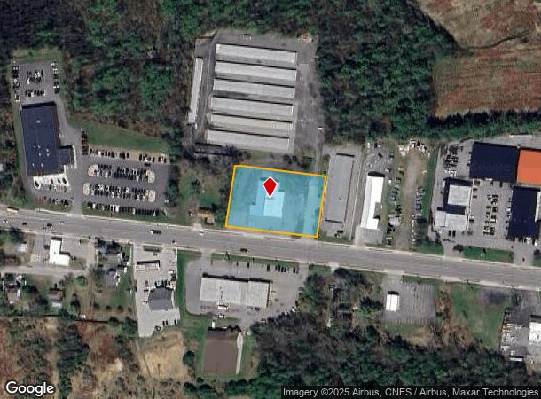
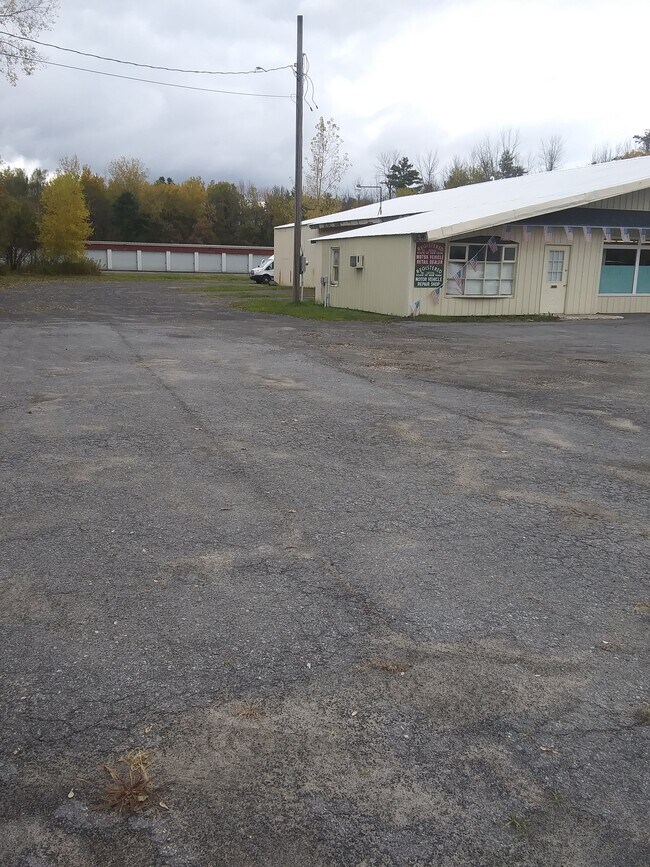
Property Record
796 State Route 3, Plattsburgh, NY 12901

This Property Is For Sale
NEARBY LISTINGS FOR SALE OR LEASE
Property Detail
796 State Route 3
094200-206-003-0001-023-005-0000
ADV MOTOR SPORTS & MATTRESS STORE
Vehiclerentalsvehiclesales
Clinton
X
New York
36019C0584E
23.005
2025
1.32 AC
2024
Upstate New York Area
100700
Other Market Areas
8,128 SF
Plattsburgh, NY
DEMOGRAPHICS near 796 State Route 3
1 Mile
3 Mile
5 Mile
2024 Total Population
955
12,943
32,811
2029 Population
952
12,843
32,578
Pop Growth 2024-2029
(0.31%)
(0.77%)
(0.71%)
Average Age
46
44
42
2024 Total Households
411
5,439
14,942
HH Growth 2024-2029
(0.24%)
(0.86%)
(0.73%)
Median Household Inc
$68,671
$62,338
$55,244
Avg Household Size
2.30
2.30
2.10
2024 Avg HH Vehicles
2.00
2.00
2.00
Median Home Value
$187,007
$160,471
$152,720
Median Year Built
1982
1977
1973
Nearby Places
- Restaurants
- Banks
- Shops
- Fitness
- Groceries
PUBLIC TRANSPORTATION
COMMUTER RAIL
Plattsburgh Amtrak Station (Adirondack - Amtrak)
DRIVE
WALK
Distance
Plattsburgh Amtrak Station (Adirondack - Amtrak)
7 min
4.2 mi
AIRPORT
Plattsburgh International
DRIVE
WALK
Distance
Plattsburgh International
11 min
6.5 mi
Patrick Leahy Burlington International
DRIVE
WALK
Distance
Patrick Leahy Burlington International
71 min
34.3 mi
Freight Ports
Montreal
DRIVE
WALK
Distance
Montreal
90 min
67.9 mi
Nearby Properties
Address
Land Use
TOTAL SIZE
Lot Size
Zoning
Address
Land Use
TOTAL SIZE
Lot Size
Zoning
103.84 AC
Address
Land Use
TOTAL SIZE
Lot Size
Zoning
404,903 SF
40.60 AC
03 - MULTI
Address
Land Use
TOTAL SIZE
Lot Size
Zoning
131,558 SF
53.50 AC
T5
Address
Land Use
TOTAL SIZE
Lot Size
Zoning
15.80 AC
Address
Land Use
TOTAL SIZE
Lot Size
Zoning
99,232 SF
21.27 AC
SD
Address
Land Use
TOTAL SIZE
Lot Size
Zoning
87,442 SF
5.32 AC
02 - SINGL
Address
Land Use
TOTAL SIZE
Lot Size
Zoning
128,028 SF
38.20 AC
T4
Address
Land Use
TOTAL SIZE
Lot Size
Zoning
83,261 SF
24.35 AC
T5
Address
Land Use
TOTAL SIZE
Lot Size
Zoning
73,095 SF
6.28 AC
T4
Address
Land Use
TOTAL SIZE
Lot Size
Zoning
167 AC
02 - SINGL
Address
Land Use
TOTAL SIZE
Lot Size
Zoning
101,758 SF
5.64 AC
T5
Address
Land Use
TOTAL SIZE
Lot Size
Zoning
117,847 SF
47.30 AC
00
Address
Land Use
TOTAL SIZE
Lot Size
Zoning
243,951 SF
21 AC
06 - INDUS
Address
Land Use
TOTAL SIZE
Lot Size
Zoning
578,793 SF
75.50 AC
T5
Address
Land Use
TOTAL SIZE
Lot Size
Zoning
218,230 SF
38.92 AC
I
Address
Land Use
TOTAL SIZE
Lot Size
Zoning
87,939 SF
8.20 AC
T5
Address
Land Use
TOTAL SIZE
Lot Size
Zoning
2.96 AC
R-2
Address
Land Use
TOTAL SIZE
Lot Size
Zoning
64,343 SF
2.30 AC
C
Address
Land Use
TOTAL SIZE
Lot Size
Zoning
145,190 SF
26.57 AC
IP
Address
Land Use
TOTAL SIZE
Lot Size
Zoning
126,842 SF
10 AC
T5
Address
Land Use
TOTAL SIZE
Lot Size
Zoning
62,148 SF
2.66 AC
T4
Address
Land Use
TOTAL SIZE
Lot Size
Zoning
59,670 SF
0.50 AC
03 - MULTI
Address
Land Use
TOTAL SIZE
Lot Size
Zoning
210,800 SF
2.42 AC
I
Address
Land Use
TOTAL SIZE
Lot Size
Zoning
50,078 SF
3.80 AC
T5
Address
Land Use
TOTAL SIZE
Lot Size
Zoning
76,598 SF
14.90 AC
12
Address
Land Use
TOTAL SIZE
Lot Size
Zoning
137,664 SF
4.82 AC
T5
Address
Land Use
TOTAL SIZE
Lot Size
Zoning
123.50 AC
Address
Land Use
TOTAL SIZE
Lot Size
Zoning
131,093 SF
5.84 AC
I
Address
Land Use
TOTAL SIZE
Lot Size
Zoning
85,252 SF
3 AC
03 - MULTI
Address
Land Use
TOTAL SIZE
Lot Size
Zoning
67,111 SF
10.46 AC
T5
The World's #1 Commercial Real Estate Marketplace
Connect with us
© 2025 CoStar Group
The information above has been obtained from sources believed reliable. While we do not doubt its accuracy we have not verified it and make no guarantee, warranty or representation about it. It is your responsibility to independently confirm its accuracy and completeness. Any projections, opinions, assumptions, or estimates used are for example only and do not represent the current or future performance of the property. The value of this transaction to you depends on tax and other factors which should be evaluated by your tax, financial, and legal advisors. You and your advisors should conduct a careful, independent investigation of the property to determine to your satisfaction the suitability of the property for your needs.