Property Record
797 Caton Rd, Lumberton, NC 28360

Property Detail
797 Caton Rd
1607-02-00901
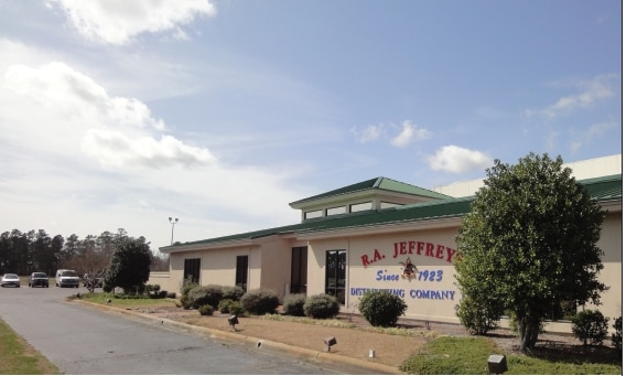
AC SAL RR S/W SIDE NC 72 BUDWEISER DISTRIBUTOR WHSE
Lightindustrial
Robeson
M2
North Carolina
B and X Area of moderate flood hazard, usually the area between the limits of the 100-year and 500-year floods.
8.85 AC
2025
North Carolina Southeast Area
2025
Other Market Areas
960602
Lumberton, NC
20,000 SF
NEARBY LISTINGS FOR SALE OR LEASE
-
-
View all Lumberton listings for sale on LoopNet.com
DEMOGRAPHICS near 797 Caton Rd
1 mile
3 mile
5 mile
2025 Total Population
516
5,950
26,403
2030 Population
544
6,215
27,429
Pop Growth 2025-2030
+ 5.43%
+ 4.45%
+ 3.89%
Average Age
36
37
39
2025 Total Households
193
2,223
10,005
HH Growth 2025-2030
+ 5.18%
+ 4.45%
+ 4.08%
Median Household Inc
$44,999
$47,265
$46,091
Avg Household Size
2.60
2.60
2.50
2025 Avg HH Vehicles
2.00
2.00
2.00
Median Home Value
$97,272
$93,547
$120,681
Median Year Built
1989
1987
1980
Nearby Places
Map Layers
Map Styles
 Street
 Aerial
Layers
 Traffic
 Biking
Places
Listings with unknown addresses are not visible on the map
- Restaurants
- Banks
- Shops
- Fitness
- Groceries
PUBLIC TRANSPORTATION
AIRPORT
Fayetteville Regional/Grannis Field
Drive
Walk
Distance
Fayetteville Regional/Grannis Field
40 min
31.3 mi
SALE & LEASE HISTORY
LISTING DATE
SALE/LEASE

Sep 25, 2016
For Lease
Sep 02, 2021
For Lease
Sep 02, 2021
For Sale
Nov 08, 2024
For Sale
Apr 12, 2019
For Sale
Nearby Properties
Address
Land Use
TOTAL SIZE
Lot Size
Zoning
Address
Land Use
TOTAL SIZE
Lot Size
Zoning
234,074 SF
63.48 AC
M2
Address
Land Use
TOTAL SIZE
Lot Size
Zoning
10,197 SF
417.66 AC
M1
Address
Land Use
TOTAL SIZE
Lot Size
Zoning
39,628 SF
34.85 AC
M2
Address
Land Use
TOTAL SIZE
Lot Size
Zoning
418,000 SF
31.52 AC
M2
Address
Land Use
TOTAL SIZE
Lot Size
Zoning
120,000 SF
17.10 AC
M2
Address
Land Use
TOTAL SIZE
Lot Size
Zoning
1,650 SF
26.34 AC
RA
Address
Land Use
TOTAL SIZE
Lot Size
Zoning
297,300 SF
128.80 AC
M2
Address
Land Use
TOTAL SIZE
Lot Size
Zoning
106,046 SF
31.24 AC
RA
Address
Land Use
TOTAL SIZE
Lot Size
Zoning
158,379 SF
17.47 AC
I2
Address
Land Use
TOTAL SIZE
Lot Size
Zoning
75,000 SF
13.84 AC
B4
Address
Land Use
TOTAL SIZE
Lot Size
Zoning
1,894 SF
11.48 AC
R3
Address
Land Use
TOTAL SIZE
Lot Size
Zoning
71,260 SF
7.69 AC
B4
Address
Land Use
TOTAL SIZE
Lot Size
Zoning
298,644 SF
18.37 AC
I2
Address
Land Use
TOTAL SIZE
Lot Size
Zoning
7,700 SF
10.66 AC
M1
Address
Land Use
TOTAL SIZE
Lot Size
Zoning
118,875 SF
7.17 AC
M1
Address
Land Use
TOTAL SIZE
Lot Size
Zoning
30,000 SF
11.31 AC
A
Address
Land Use
TOTAL SIZE
Lot Size
Zoning
173,232 SF
13.83 AC
M2
Address
Land Use
TOTAL SIZE
Lot Size
Zoning
134,250 SF
56.70 AC
M2
Address
Land Use
TOTAL SIZE
Lot Size
Zoning
24,000 SF
14.45 AC
Address
Land Use
TOTAL SIZE
Lot Size
Zoning
16,577 SF
84.06 AC
B4
Address
Land Use
TOTAL SIZE
Lot Size
Zoning
26,508 SF
9.88 AC
Address
Land Use
TOTAL SIZE
Lot Size
Zoning
24,511 SF
40 AC
I2
Address
Land Use
TOTAL SIZE
Lot Size
Zoning
260,616 SF
10.35 AC
M2
Address
Land Use
TOTAL SIZE
Lot Size
Zoning
9,439 SF
6.40 AC
Address
Land Use
TOTAL SIZE
Lot Size
Zoning
25,056 SF
6.76 AC
Address
Land Use
TOTAL SIZE
Lot Size
Zoning
117,880 SF
6.24 AC
I2
Address
Land Use
TOTAL SIZE
Lot Size
Zoning
24,658 SF
2.98 AC
Address
Land Use
TOTAL SIZE
Lot Size
Zoning
5,675 SF
1.76 AC
B4
Address
Land Use
TOTAL SIZE
Lot Size
Zoning
12,960 SF
75.29 AC
Address
Land Use
TOTAL SIZE
Lot Size
Zoning
149,575 SF
28.83 AC
M2
The World's #1 Commercial Real Estate Marketplace
Connect with us
© 2026 CoStar Group
The information above has been obtained from sources believed reliable. While we do not doubt its accuracy we have not verified it and make no guarantee, warranty or representation about it. It is your responsibility to independently confirm its accuracy and completeness. Any projections, opinions, assumptions, or estimates used are for example only and do not represent the current or future performance of the property. The value of this transaction to you depends on tax and other factors which should be evaluated by your tax, financial, and legal advisors. You and your advisors should conduct a careful, independent investigation of the property to determine to your satisfaction the suitability of the property for your needs.