Property Record
797 Succotash Rd, Wakefield, RI 02879
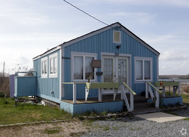

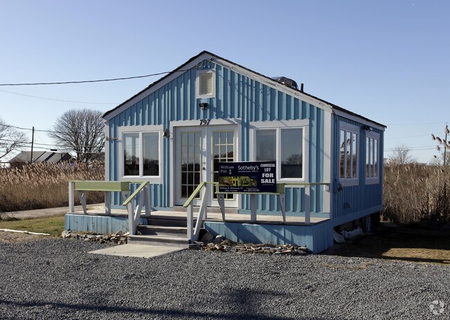
Property Detail
797 Succotash Rd
SKIN-008703-000000-000003
WASHINGTON
Commercialbuilding
Rhode Island
CW
3
VE and V1-30 Coastal areas with a 1% or greater chance of flooding and an additional hazard associated with storm waves. These areas have a 26% chance of flooding over the life of a 30-year mortgage.
0.09 AC
2025
Washington County
2025
Providence
051302
Providence-Warwick, RI-MA
400 SF
NEARBY LISTINGS FOR SALE OR LEASE
DEMOGRAPHICS near 797 Succotash Rd
1 mile
3 mile
5 mile
2025 Total Population
1,763
10,660
25,980
2030 Population
1,891
11,453
26,955
Pop Growth 2025-2030
+ 7.26%
+ 7.44%
+ 3.75%
Average Age
49
47
47
2025 Total Households
785
4,817
11,660
HH Growth 2025-2030
+ 7.26%
+ 7.31%
+ 3.71%
Median Household Inc
$103,482
$90,250
$101,673
Avg Household Size
2.20
2.20
2.20
2025 Avg HH Vehicles
2.00
2.00
2.00
Median Home Value
$791,553
$794,210
$712,220
Median Year Built
1971
1974
1975
Nearby Places
Map Layers
Map Styles
 Street
 Aerial
Layers
 Traffic
 Biking
Places
Listings with unknown addresses are not visible on the map
- Restaurants
- Banks
- Shops
- Fitness
- Groceries
PUBLIC TRANSPORTATION
COMMUTER RAIL
Kingston Amtrak Station (Northeast Regional - Amtrak)
Drive
Walk
Distance
Kingston Amtrak Station (Northeast Regional - Amtrak)
18 min
9.9 mi
AIRPORT
Rhode Island Tf Green International
Drive
Walk
Distance
Rhode Island Tf Green International
46 min
30.7 mi
Freight Ports
Port of Davisville, RI
Drive
Walk
Distance
Port of Davisville, RI
36 min
20.5 mi
Nearby Properties
Address
Land Use
TOTAL SIZE
Lot Size
Zoning
Address
Land Use
TOTAL SIZE
Lot Size
Zoning
115.46 AC
R-20
Address
Land Use
TOTAL SIZE
Lot Size
Zoning
4.62 AC
R80
Address
Land Use
TOTAL SIZE
Lot Size
Zoning
25.33 AC
P
Address
Land Use
TOTAL SIZE
Lot Size
Zoning
4,093 SF
18.49 AC
P
Address
Land Use
TOTAL SIZE
Lot Size
Zoning
94.91 AC
P
Address
Land Use
TOTAL SIZE
Lot Size
Zoning
73.94 AC
P
Address
Land Use
TOTAL SIZE
Lot Size
Zoning
50.20 AC
R200
Address
Land Use
TOTAL SIZE
Lot Size
Zoning
41,560 SF
13.71 AC
GI
Address
Land Use
TOTAL SIZE
Lot Size
Zoning
16.05 AC
R-20
Address
Land Use
TOTAL SIZE
Lot Size
Zoning
4,041 SF
4.82 AC
P
Address
Land Use
TOTAL SIZE
Lot Size
Zoning
4.20 AC
P
Address
Land Use
TOTAL SIZE
Lot Size
Zoning
51.16 AC
R200
Address
Land Use
TOTAL SIZE
Lot Size
Zoning
15,089 SF
14.14 AC
P
Address
Land Use
TOTAL SIZE
Lot Size
Zoning
12.70 AC
P
Address
Land Use
TOTAL SIZE
Lot Size
Zoning
2,738 SF
5.97 AC
R80
Address
Land Use
TOTAL SIZE
Lot Size
Zoning
2.82 AC
P
Address
Land Use
TOTAL SIZE
Lot Size
Zoning
11.03 AC
B-C
Address
Land Use
TOTAL SIZE
Lot Size
Zoning
739 SF
18.29 AC
R20
Address
Land Use
TOTAL SIZE
Lot Size
Zoning
8.04 AC
R-20
Address
Land Use
TOTAL SIZE
Lot Size
Zoning
11.53 AC
R-10
Address
Land Use
TOTAL SIZE
Lot Size
Zoning
2,999 SF
61 AC
OS
Address
Land Use
TOTAL SIZE
Lot Size
Zoning
16.58 AC
P
Address
Land Use
TOTAL SIZE
Lot Size
Zoning
25.44 AC
OS
Address
Land Use
TOTAL SIZE
Lot Size
Zoning
962 SF
66.73 AC
R200
Address
Land Use
TOTAL SIZE
Lot Size
Zoning
32.50 AC
R200
Address
Land Use
TOTAL SIZE
Lot Size
Zoning
1.78 AC
B-A
Address
Land Use
TOTAL SIZE
Lot Size
Zoning
1.03 AC
CW
Address
Land Use
TOTAL SIZE
Lot Size
Zoning
18,531 SF
0.47 AC
B-A
Address
Land Use
TOTAL SIZE
Lot Size
Zoning
29.52 AC
R-10
Address
Land Use
TOTAL SIZE
Lot Size
Zoning
26.94 AC
R80
The World's #1 Commercial Real Estate Marketplace
Connect with us
© 2026 CoStar Group
The information above has been obtained from sources believed reliable. While we do not doubt its accuracy we have not verified it and make no guarantee, warranty or representation about it. It is your responsibility to independently confirm its accuracy and completeness. Any projections, opinions, assumptions, or estimates used are for example only and do not represent the current or future performance of the property. The value of this transaction to you depends on tax and other factors which should be evaluated by your tax, financial, and legal advisors. You and your advisors should conduct a careful, independent investigation of the property to determine to your satisfaction the suitability of the property for your needs.