Property Record
797 Sw 41 St, Bentonville, AR 72713


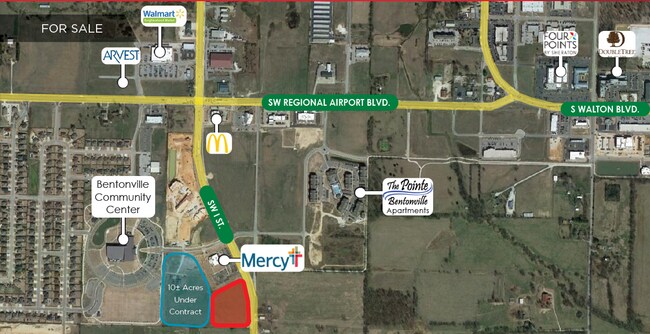

Property Detail
797 Sw 41 St
Fayetteville-Springdale-Rogers, AR
REPLAT 6/07/2017 2017-476 & REPLAT 6/21/2022 L202241025
01-16610-001
BENTON COUNTY
Commercialacreage
Arkansas
B and X Area of moderate flood hazard, usually the area between the limits of the 100-year and 500-year floods.
26
2025
11.46 AC
2025
Bentonville
020604
Fayetteville/Springdale/Rogers
3,654 SF
NEARBY LISTINGS FOR SALE OR LEASE
DEMOGRAPHICS near 797 Sw 41 St
1 mile
3 mile
5 mile
2025 Total Population
6,007
52,578
129,373
2030 Population
6,668
58,568
143,574
Pop Growth 2025-2030
+ 11.00%
+ 11.39%
+ 10.98%
Average Age
33
35
36
2025 Total Households
2,132
20,395
48,354
HH Growth 2025-2030
+ 11.40%
+ 11.71%
+ 11.34%
Median Household Inc
$125,391
$111,412
$107,882
Avg Household Size
2.80
2.50
2.60
2025 Avg HH Vehicles
2.00
2.00
2.00
Median Home Value
$422,075
$414,047
$411,854
Median Year Built
2010
2007
2005
Nearby Places
Map Layers
Map Styles
 Street
 Aerial
Layers
 Traffic
 Biking
Places
Listings with unknown addresses are not visible on the map
- Restaurants
- Banks
- Shops
- Fitness
- Groceries
PUBLIC TRANSPORTATION
AIRPORT
Northwest Arkansas Ntl
Drive
Walk
Distance
Northwest Arkansas Ntl
22 min
9.6 mi
Freight Ports
Tulsa Port of Inola
Drive
Walk
Distance
Tulsa Port of Inola
115 min
92.7 mi
SALE & LEASE HISTORY
LISTING DATE
SALE/LEASE

Jun 22, 2018
For Sale
Nearby Properties
Address
Land Use
TOTAL SIZE
Lot Size
Zoning
Address
Land Use
TOTAL SIZE
Lot Size
Zoning
147,199 SF
16.11 AC
Address
Land Use
TOTAL SIZE
Lot Size
Zoning
344,315 SF
12.74 AC
Address
Land Use
TOTAL SIZE
Lot Size
Zoning
18,622 SF
104.67 AC
Address
Land Use
TOTAL SIZE
Lot Size
Zoning
516,588 SF
24.53 AC
Address
Land Use
TOTAL SIZE
Lot Size
Zoning
384,427 SF
10.51 AC
Address
Land Use
TOTAL SIZE
Lot Size
Zoning
216,538 SF
22.14 AC
Address
Land Use
TOTAL SIZE
Lot Size
Zoning
1,159,141 SF
176.54 AC
Address
Land Use
TOTAL SIZE
Lot Size
Zoning
472,987 SF
3.75 AC
Address
Land Use
TOTAL SIZE
Lot Size
Zoning
381,924 SF
10.23 AC
Address
Land Use
TOTAL SIZE
Lot Size
Zoning
307,725 SF
9.36 AC
Address
Land Use
TOTAL SIZE
Lot Size
Zoning
546,195 SF
15.80 AC
Address
Land Use
TOTAL SIZE
Lot Size
Zoning
187,529 SF
37.78 AC
Address
Land Use
TOTAL SIZE
Lot Size
Zoning
254,163 SF
10.98 AC
Address
Land Use
TOTAL SIZE
Lot Size
Zoning
573,822 SF
10.56 AC
Address
Land Use
TOTAL SIZE
Lot Size
Zoning
375,605 SF
24.54 AC
Address
Land Use
TOTAL SIZE
Lot Size
Zoning
247,292 SF
1.57 AC
Address
Land Use
TOTAL SIZE
Lot Size
Zoning
234,432 SF
19.98 AC
Address
Land Use
TOTAL SIZE
Lot Size
Zoning
299,595 SF
18 AC
Address
Land Use
TOTAL SIZE
Lot Size
Zoning
458,697 SF
35.35 AC
Address
Land Use
TOTAL SIZE
Lot Size
Zoning
42,848 SF
3.08 AC
Address
Land Use
TOTAL SIZE
Lot Size
Zoning
251,590 SF
6.95 AC
Address
Land Use
TOTAL SIZE
Lot Size
Zoning
270,199 SF
10.23 AC
Address
Land Use
TOTAL SIZE
Lot Size
Zoning
17,340 SF
14.15 AC
Address
Land Use
TOTAL SIZE
Lot Size
Zoning
283,760 SF
11.61 AC
Address
Land Use
TOTAL SIZE
Lot Size
Zoning
256,469 SF
3.18 AC
Address
Land Use
TOTAL SIZE
Lot Size
Zoning
108,103 SF
8.53 AC
Address
Land Use
TOTAL SIZE
Lot Size
Zoning
97,660 SF
5.35 AC
Address
Land Use
TOTAL SIZE
Lot Size
Zoning
171,746 SF
9.32 AC
Address
Land Use
TOTAL SIZE
Lot Size
Zoning
264,824 SF
17.24 AC
The World's #1 Commercial Real Estate Marketplace
Connect with us
© 2026 CoStar Group
The information above has been obtained from sources believed reliable. While we do not doubt its accuracy we have not verified it and make no guarantee, warranty or representation about it. It is your responsibility to independently confirm its accuracy and completeness. Any projections, opinions, assumptions, or estimates used are for example only and do not represent the current or future performance of the property. The value of this transaction to you depends on tax and other factors which should be evaluated by your tax, financial, and legal advisors. You and your advisors should conduct a careful, independent investigation of the property to determine to your satisfaction the suitability of the property for your needs.