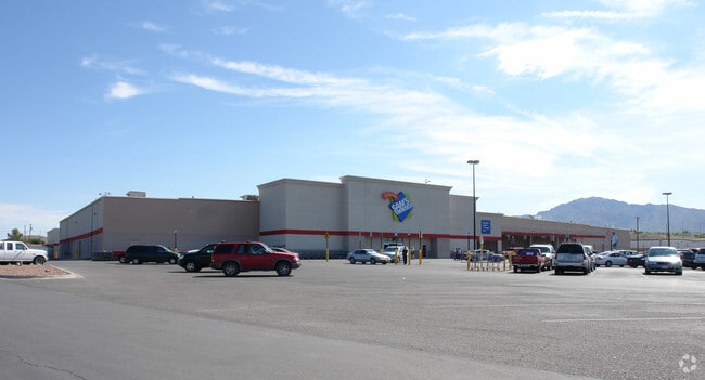
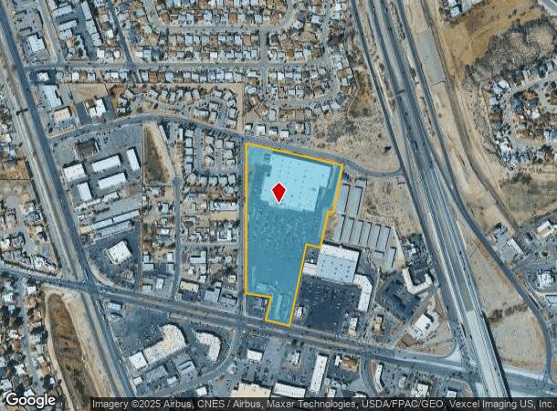
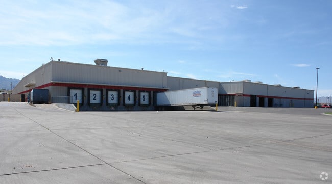
Property Record
7970 N Mesa St, El Paso, TX 79932
NEARBY LISTINGS FOR SALE OR LEASE
Property Detail
7970 N Mesa St
El Paso, TX
Boykin Commercial District #3
B694-999-0010-0100
1 BOYKIN COMMERCIAL DISTRICT #3 1 & NWLY PT OF 2 & PT OF BLK 1 BEG 20.51 E & 158.73 N OF SWC OF BOYKIN COMMERCIAL DISTRICT (13.5360 AC)
Commercialnec
El Paso
2024
Texas
2025
13.54 AC
001204
West
143,731 SF
El Paso
DEMOGRAPHICS near 7970 N Mesa St
1 Mile
3 Mile
5 Mile
2024 Total Population
8,138
85,947
146,307
2029 Population
8,173
87,022
148,813
Pop Growth 2024-2029
+ 0.43%
+ 1.25%
+ 1.71%
Average Age
39
39
38
2024 Total Households
3,060
31,058
53,694
HH Growth 2024-2029
+ 0.39%
+ 1.18%
+ 1.63%
Median Household Inc
$41,079
$67,958
$67,688
Avg Household Size
2.60
2.70
2.70
2024 Avg HH Vehicles
2.00
2.00
2.00
Median Home Value
$172,647
$198,766
$219,645
Median Year Built
1983
1987
1989
Nearby Places
Map Layers
Map Styles
 Street
 Aerial
- Restaurants
- Banks
- Shops
- Fitness
- Groceries
PUBLIC TRANSPORTATION
AIRPORT
El Paso International
DRIVE
WALK
Distance
El Paso International
36 min
22.8 mi
Freight Ports
Port of Corpus Christi
DRIVE
WALK
Distance
Port of Corpus Christi
693 min
703.8 mi
Nearby Properties
Address
Land Use
TOTAL SIZE
Lot Size
Zoning
Address
Land Use
TOTAL SIZE
Lot Size
Zoning
127,552 SF
14.24 AC
C4
Address
Land Use
TOTAL SIZE
Lot Size
Zoning
545,506 SF
50.94 AC
M1
Address
Land Use
TOTAL SIZE
Lot Size
Zoning
236,134 SF
14.49 AC
C1
Address
Land Use
TOTAL SIZE
Lot Size
Zoning
248,997 SF
14.85 AC
C3S
Address
Land Use
TOTAL SIZE
Lot Size
Zoning
588,864 SF
27.37 AC
AO
Address
Land Use
TOTAL SIZE
Lot Size
Zoning
199,384 SF
17.91 AC
C4
Address
Land Use
TOTAL SIZE
Lot Size
Zoning
243,741 SF
22.80 AC
R3
Address
Land Use
TOTAL SIZE
Lot Size
Zoning
235,843 SF
11.55 AC
C1
Address
Land Use
TOTAL SIZE
Lot Size
Zoning
246,802 SF
11.08 AC
C3
Address
Land Use
TOTAL SIZE
Lot Size
Zoning
191,148 SF
20.29 AC
C3
Address
Land Use
TOTAL SIZE
Lot Size
Zoning
185,273 SF
11.78 AC
C3S
Address
Land Use
TOTAL SIZE
Lot Size
Zoning
160,509 SF
8.85 AC
A2
Address
Land Use
TOTAL SIZE
Lot Size
Zoning
103,525 SF
7 AC
M1
Address
Land Use
TOTAL SIZE
Lot Size
Zoning
201,291 SF
43.23 AC
R3
Address
Land Use
TOTAL SIZE
Lot Size
Zoning
115,155 SF
4.63 AC
C2C
Address
Land Use
TOTAL SIZE
Lot Size
Zoning
119,020 SF
8.56 AC
C3S
Address
Land Use
TOTAL SIZE
Lot Size
Zoning
142,567 SF
5.74 AC
A2S
Address
Land Use
TOTAL SIZE
Lot Size
Zoning
212,938 SF
9.38 AC
C1
Address
Land Use
TOTAL SIZE
Lot Size
Zoning
289,013 SF
6.84 AC
C3
Address
Land Use
TOTAL SIZE
Lot Size
Zoning
159,851 SF
7.19 AC
A2S
Address
Land Use
TOTAL SIZE
Lot Size
Zoning
65,601 SF
15.64 AC
R2A
Address
Land Use
TOTAL SIZE
Lot Size
Zoning
119,191 SF
9.05 AC
C3
Address
Land Use
TOTAL SIZE
Lot Size
Zoning
187,488 SF
9.54 AC
A2
Address
Land Use
TOTAL SIZE
Lot Size
Zoning
640 AC
PMD
Address
Land Use
TOTAL SIZE
Lot Size
Zoning
212,174 SF
8.44 AC
A2S
Address
Land Use
TOTAL SIZE
Lot Size
Zoning
136,776 SF
16.26 AC
C4S
Address
Land Use
TOTAL SIZE
Lot Size
Zoning
110,530 SF
14.19 AC
C1
Address
Land Use
TOTAL SIZE
Lot Size
Zoning
156,261 SF
11.35 AC
C3S
Address
Land Use
TOTAL SIZE
Lot Size
Zoning
134,044 SF
12.04 AC
C3
The World's #1 Commercial Real Estate Marketplace
Connect with us
© 2025 CoStar Group
The information above has been obtained from sources believed reliable. While we do not doubt its accuracy we have not verified it and make no guarantee, warranty or representation about it. It is your responsibility to independently confirm its accuracy and completeness. Any projections, opinions, assumptions, or estimates used are for example only and do not represent the current or future performance of the property. The value of this transaction to you depends on tax and other factors which should be evaluated by your tax, financial, and legal advisors. You and your advisors should conduct a careful, independent investigation of the property to determine to your satisfaction the suitability of the property for your needs.